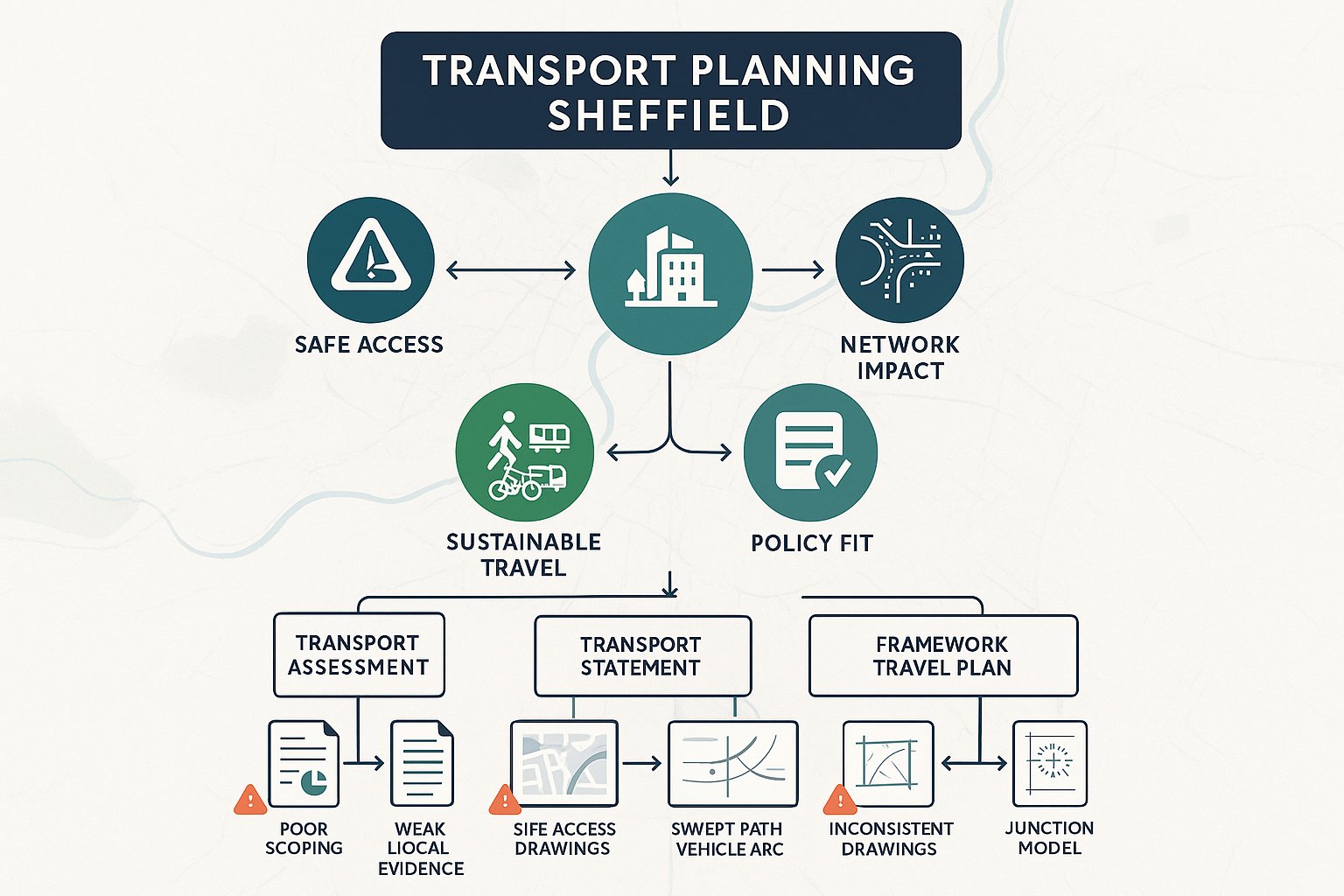
If you work on development in Sheffield, you already know transport can make or break a planning application. A scheme may look strong in design, heritage, viability and land use terms, yet still stall if access is weak, junction impacts are brushed over, or sustainable travel measures feel like an afterthought. That is exactly why transport planning Sheffield matters so much in practice.
In Sheffield, transport is not just about counting cars. We have to deal with steep hills, tight urban streets, river corridors, tram infrastructure, changing city-centre priorities, and a policy direction that pushes hard toward walking, wheeling, cycling and public transport. Add in local authority expectations, pre-application discussions, modelling requirements and travel plan commitments, and it becomes clear that a transport submission has to be both technically sound and locally tuned.
In this guide, we set out what applicants, architects, planners, solicitors, surveyors and developers need to know in 2026. We cover when a Transport Assessment, Transport Statement or Travel Plan is likely to be needed, how Sheffield’s planning context influences requirements, what documents usually sit behind a credible submission, and the issues that most often delay decisions.
Our aim is simple: to explain how to prepare transport evidence that reads clearly, answers the right questions, and gives Sheffield City Council confidence that a proposal will function safely and sustainably.
What Transport Planning Means For Development In Sheffield
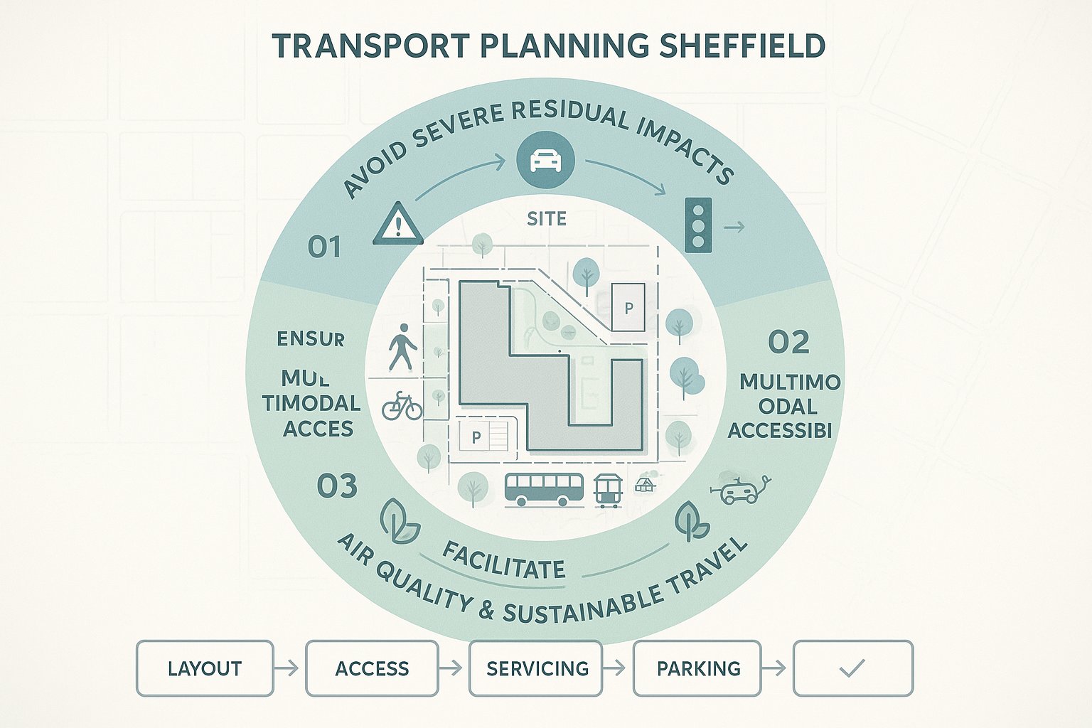
Transport planning for development is the process of showing that a proposal can be accessed safely, will not create unacceptable effects on the highway network, and supports wider travel policy. In Sheffield, that broad definition has real weight because the city’s transport objectives go beyond traffic flow alone.
A planning application is usually expected to demonstrate three things. First, the development should not lead to severe residual impacts on road safety or congestion. Second, it should respond to the site’s actual accessibility by foot, cycle, bus, tram and rail. Third, it should align with local ambitions around decarbonisation, air quality and reduced car dependence, particularly in central locations.
That means transport planning Sheffield work often sits at the intersection of highways engineering, planning policy and placemaking. We are not simply forecasting turning movements at a junction. We are also testing whether the development is in the right place for its trip profile, whether parking is proportionate, whether deliveries can be managed, and whether people have realistic alternatives to driving.
For applicants, the practical implication is straightforward: transport evidence should be prepared early, not bolted on at the end. In our experience, the strongest schemes use transport planning to shape the layout, access, servicing, parking and active travel offer from the start. That usually leads to a smoother application and fewer late-stage surprises.
When A Transport Assessment, Transport Statement, Or Travel Plan Is Needed
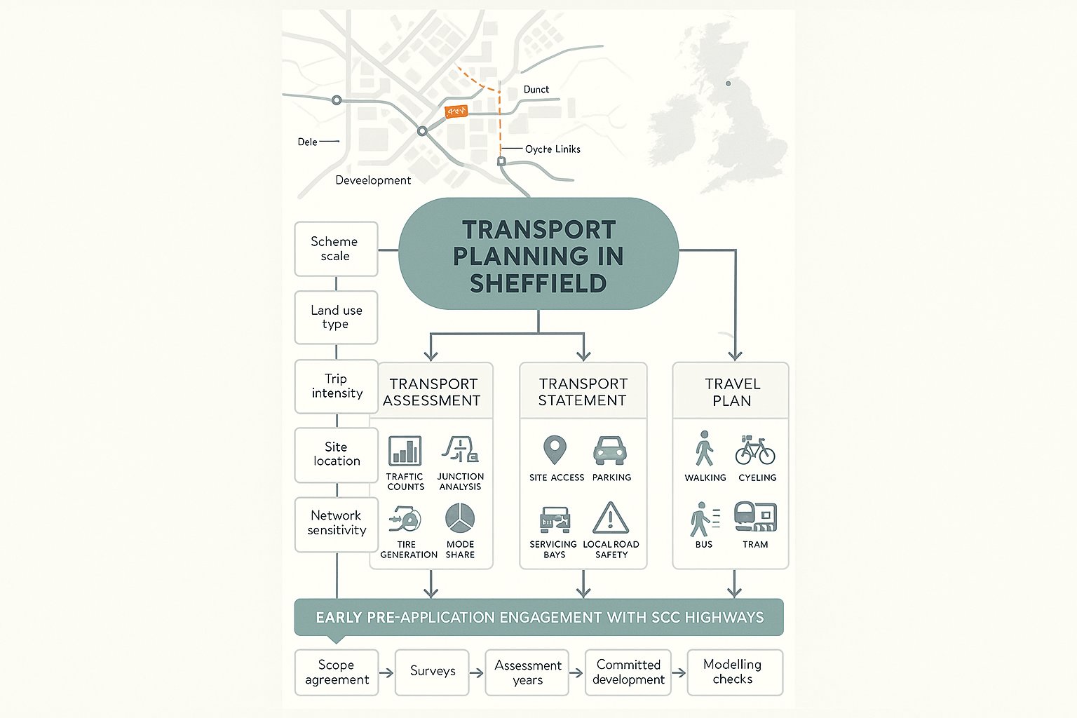
The level of transport evidence required in Sheffield depends on the scale, type and location of development, and on the sensitivity of the surrounding network. There is no single trigger that covers every scheme, so professional judgement and early scoping with the council matter.
A Transport Assessment (TA) is typically needed for larger or more trip-intensive proposals. Think major residential development, substantial commercial floorspace, education uses, logistics activity, or sites that could materially affect nearby junctions, strategic corridors or sustainable travel networks. A TA is the fuller document: it assesses existing conditions, forecasts trips, reviews mode share, tests traffic impact and sets out mitigation.
A Transport Statement (TS) is more proportionate. It is often suitable for smaller schemes with limited transport effects, where the main questions relate to access, parking, servicing and local safety rather than wider network capacity.
A Travel Plan (TP) is commonly expected where a development will generate significant person trips. That may include major residential, office, health, education or mixed-use schemes. For outline or phased applications, a Framework Travel Plan is often the right starting point.
In Sheffield, pre-application engagement with SCC Highways is usually the smart move. It helps agree scope, survey requirements, future assessment years, committed development assumptions and whether modelling will be needed. Frankly, many delays begin when applicants guess the scope instead of agreeing it.
How Sheffield’s Planning Context Shapes Transport Requirements
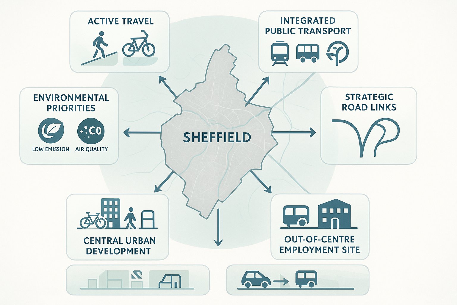
Sheffield’s transport requirements are shaped by more than national policy. Local strategy matters, and it can materially affect what the authority expects to see in an application.
At city level, the Sheffield Transport Strategy and the City Centre Access and Movement Plan point toward a network that supports growth while reducing car dominance, improving public realm and strengthening sustainable travel choices. At a wider scale, South Yorkshire Mayoral Combined Authority transport priorities reinforce the importance of integrated public transport, active travel corridors and strategic network performance.
For applicants, this means a technically acceptable highway arrangement may still be challenged if it pulls against the direction of local policy. A city-centre scheme with generous car parking but weak cycle provision, for example, may face tougher questions than an out-of-centre employment site with different operational needs. The planning context also affects how mitigation is viewed. Measures that improve walking connections, bus stop access or cycle parking often carry more weight than simply widening carriageway.
This is where local knowledge becomes valuable. We find that Sheffield submissions are strongest when they are written with a clear understanding of the city’s transport strategy, not just generic UK guidance. That local alignment tends to make consultation more productive and recommendations more credible.
Key Local Factors That Commonly Affect Sheffield Sites
Several recurring local factors shape transport evidence in Sheffield.
Topography is a big one. Steep gradients can affect walking catchments, cycling attractiveness, accessibility for wheelchair users and even the practicality of certain access arrangements.
Street pattern and constraint matter too, especially in and around the centre. Sheffield has older streets, tight junction geometry and locations where visibility, servicing and turning manoeuvres need careful thought.
Existing public transport and strategic links are another major consideration. Supertram, rail stations, bus corridors and the strategic road network can all influence mode share expectations and impact scoping.
And then there is the city’s air quality and carbon agenda. In some locations, especially central and highly connected areas, the authority will expect stronger justification for car-based trip assumptions and parking levels. A one-size-fits-all approach rarely survives first contact with a real Sheffield site.
The Main Transport Planning Documents Used To Support An Application
A robust Sheffield submission rarely relies on one document alone. Most planning applications need a package of transport material, with the content scaled to the nature of the scheme.
The starting point is usually a Transport Assessment or Transport Statement. That is the core narrative explaining existing conditions, accessibility, trip generation, likely impacts and mitigation. Depending on the proposal, it may be supported by an Access Appraisal, Technical Note or Delivery and Servicing information.
Where person-trip generation is important, a Travel Plan sits alongside the TA or TS. For phased, outline or multi-occupier development, a Framework Travel Plan is common because detailed occupier information may not exist yet.
Applications also frequently need site access drawings, including geometry, visibility splays, gradients and footway tie-ins. If larger vehicles will use the site, swept-path analysis is often required to prove refuse vehicles, delivery vehicles or emergency vehicles can manoeuvre safely.
If junctions may be affected, supporting capacity modelling and queue analysis can be necessary. In some cases, a parking strategy, cycle parking schedule, construction traffic note or road safety review also helps.
The key is consistency. The drawings, schedules and technical reports should tell the same story. If the TA says a site promotes cycling but the layout buries cycle parking in an awkward corner, the weakness is obvious.
Transport Assessment Vs Transport Statement Vs Framework Travel Plan
These documents are related, but they do different jobs.
A Transport Assessment is the detailed option. It typically includes baseline conditions, sustainable travel review, trip generation, distribution and assignment, junction impact testing, road safety analysis and mitigation. It is suited to schemes where the authority needs evidence on network effects, not just access basics.
A Transport Statement is shorter and more focused. It still needs to be evidence-based, but it is generally used where impacts are modest. A good TS will cover accessibility, access design, parking, servicing and local highway considerations without pretending to be a full strategic model.
A Framework Travel Plan is more about behaviour than capacity. It sets out how sustainable travel will be encouraged through measures, targets, management arrangements, monitoring and review. For outline schemes, it creates the structure that later occupiers or phases can convert into a detailed Full Travel Plan.
Choosing the wrong document is a surprisingly common error. Too little evidence invites objection. Too much irrelevant material just makes the submission harder to interrogate.
How Site Access, Highway Safety, And Visibility Are Assessed
Access is one of the first transport issues most case officers and highways consultees look at, because it is easy to visualise and hard to fix late. In Sheffield, access design often needs careful handling due to level changes, constrained frontages and busy pedestrian environments.
Assessment usually begins with the physical arrangement: the location of the access, its width, junction radii, internal tracking, gradient and relationship to nearby junctions, crossings, bus stops and cycle routes. The authority will want confidence that vehicles can enter and leave safely, that larger service vehicles can manoeuvre without conflict, and that pedestrians are not pushed into awkward or unsafe conditions.
Visibility splays are central. These are reviewed against the speed environment and design standards, but context matters. A technically available splay on paper may not feel robust if it cuts across footways with heavy pedestrian movement or sits close to a bend, crossing or tram-related constraint.
Highway safety assessment also looks at collision history. Personal injury collision data helps identify whether a location already shows patterns of turning conflict, speed-related issues or vulnerable road user risk.
We also need to think multi-modally. A site access is not acceptable just because cars can turn. It has to work alongside footway continuity, cycle movement, wheelchair access, refuse collection and, in some cases, loading activity. Good transport planning Sheffield reports explain those interactions clearly and use drawings that match the real on-street conditions, not idealised assumptions.
Sustainable Travel Expectations For Sheffield Developments
In Sheffield, sustainable travel is not a decorative chapter at the back of the report. It is central to whether a proposal aligns with policy.
The city’s direction of travel is clear: developments should help increase walking, wheeling, cycling, bus and tram use, while reducing unnecessary single-occupancy car trips. That expectation is especially strong in accessible urban areas and the city centre, where public transport and active travel options are often realistic alternatives.
For applicants, that affects several parts of a scheme. Parking levels need to be justified in relation to location and use. Cycle parking has to be convenient, secure and proportionate. Entrances should connect naturally to surrounding footways and crossings. Staff and visitor information may need to include public transport details, cycle facilities and incentives. Larger schemes may also be expected to nominate a Travel Plan coordinator and monitor outcomes.
What matters most is credibility. Authorities can usually tell when a sustainable travel section has been copied in from another project. If the report claims strong bus accessibility but ignores the steep route to the stop, or promotes cycling without usable storage and showers, the gap is obvious.
Walking, Cycling, Public Transport, And Accessibility Considerations
A convincing accessibility appraisal in Sheffield should look beyond raw distances.
For walking, we assess route quality as well as proximity: gradients, crossing opportunities, lighting, footway width, surface condition and personal security. A five-minute walk uphill on a narrow pavement is not the same as a flat, direct route.
For cycling, we consider whether people can realistically and safely reach local routes, whether on-site parking is secure and well located, and whether supporting facilities are needed. On steeper sites, e-bikes and adapted cycles may also be relevant to the discussion.
For public transport, bus and tram accessibility should be demonstrated with real route options, service quality and catchment logic, not just a map circle. Rail can also matter for larger employment or mixed-use schemes.
And inclusive access should run through the whole assessment. That means thinking about disabled users, wheelchair access, dropped kerbs, gradients, tactile paving, rest opportunities and how people with different mobility needs actually experience the route network. In practice, the best submissions treat accessibility as a design issue, not a compliance box.
Junction Capacity, Traffic Impact, And Network Performance
Where development traffic may materially affect the network, Sheffield applications often need a more analytical review of junction capacity and operational performance. This is where transport planning becomes particularly technical.
The first step is usually to establish baseline traffic conditions and identify which junctions genuinely merit assessment. That should be agreed through scoping where possible. Assessing too few junctions creates risk: assessing every arm of every nearby node wastes time and muddies the picture.
Depending on junction type, tools such as PICADY, ARCADY and LINSIG may be used, alongside spreadsheet-based priority assessments or microsimulation on more complex schemes. The aim is to understand how the development changes queue lengths, delays, reserve capacity and network resilience in relevant peak periods.
But modelling outputs are only part of the story. We also need to sense-check trip rates, distribution assumptions, committed development, background growth and the practicality of any mitigation. A model can produce precise-looking figures from weak assumptions. Experienced reviewers notice.
In Sheffield, cumulative impact can be a live issue, especially where constrained junctions already operate under pressure or where city-centre movement priorities are changing. The question is rarely whether traffic rises at all: it is whether the residual effect is acceptable in context and whether realistic mitigation can address it.
Sometimes mitigation is geometric. Sometimes it is signal optimisation, servicing management, parking restraint or stronger sustainable travel measures. The right answer depends on the location, not on a template.
Common Transport Planning Issues That Delay Sheffield Applications
Most delayed applications do not fail because transport is impossibly complex. They fail because avoidable gaps are left in the submission.
One of the biggest issues is poor scoping. If applicants do not speak to SCC Highways early, they may submit the wrong level of report, use the wrong survey base, omit key junctions or assess the wrong future year. That can trigger rounds of clarification that eat months.
Another common problem is thin evidence quality. We regularly see reports that rely on generic text, untested assumptions or accessibility analysis that does not reflect Sheffield’s actual terrain and movement patterns. If the authority suspects the report has been assembled quickly without local understanding, confidence drops fast.
Sustainable travel weakness is another frequent cause of challenge. That might mean inadequate cycle parking, poor walking links, no convincing Travel Plan measures, or parking provision that conflicts with the accessibility of the site.
Then there are access and safety issues: insufficient visibility, awkward refuse tracking, conflict with pedestrians, or access points too close to nearby junctions or crossings.
Finally, some schemes are delayed by simple inconsistency. The site layout, planning statement, TA, travel plan and architectural drawings all describe slightly different things. Those disconnects matter because highways officers need a coherent package they can condition and defend.
In our experience, concise, locally tailored reporting usually performs better than overlong documents padded with irrelevant material. Decision-makers want clear answers to real site questions.
How To Prepare A Strong Transport Planning Submission In Sheffield
A strong submission starts earlier than many teams expect. By the time the planning statement is being polished, most of the key transport decisions should already have been tested.
We recommend beginning with site-specific scoping. Speak to SCC Highways early and, where relevant, consider the wider South Yorkshire context too. Confirm whether a TA, TS or Travel Plan is expected, what survey information is needed, which junctions should be assessed, and what future assessment years are appropriate.
Next, make sure the site layout responds to transport reality. Access, servicing, refuse collection, pedestrian routes, cycle parking and disabled parking should be designed into the scheme, not retrofitted after comments arrive.
Then align the evidence with local policy direction. In Sheffield, that usually means taking sustainable travel seriously, especially in accessible locations. If car parking is proposed above what the site context appears to justify, explain why. If walking and cycling are key to the mode split, show the routes and facilities properly.
Technical work should be proportionate but robust. Use realistic trip rates, credible mode share assumptions and transparent modelling inputs. If mitigation is proposed, it should be practical, deliverable and tied to the actual impacts identified.
Finally, submit a package that is internally consistent. Drawings, reports and schedules should line up.
For project teams who need support, firms with locally aware experience can save a lot of friction. At ML Traffic, for example, the focus is on concise, accurate transport engineering reports tailored to local authority thresholds and planning contexts. That sort of approach tends to help because Sheffield rarely rewards generic transport paperwork.
Conclusion
Good transport planning in Sheffield is really about credibility. Can the application show, in a clear and proportionate way, that the development will function safely, fit the network, and support the city’s push toward more sustainable travel? If the answer is yes, the planning path is usually smoother.
For developers, architects, planners and advisers, the lesson is not to treat transport as a late technical add-on. In Sheffield, it shapes access, parking, servicing, layout, policy compliance and, sometimes, the entire planning strategy. Early scoping, local awareness and coherent reporting make a noticeable difference.
In practical terms, the best submissions are the ones that answer the authority’s real concerns before they are raised: why this level of parking, why this access point, why this trip profile, why this mitigation. That is the standard transport planning Sheffield work needs to meet in 2026. And when it does, applications tend to move with fewer surprises and stronger confidence from all sides.
Transport Planning Sheffield – Frequently Asked Questions
What is transport planning in Sheffield and why is it important for development?
Transport planning in Sheffield ensures that new developments support safe, efficient, and sustainable travel. It is crucial because it aligns with local policies on reducing car dependency, improving air quality, and addressing the city’s unique topography and constrained street layout to enable smoother planning approvals.
When is a Transport Assessment, Transport Statement, or Travel Plan required for a Sheffield development?
A Transport Assessment is needed for larger or traffic-intensive schemes, a Transport Statement suits smaller developments with limited impacts, and a Travel Plan is expected for developments generating significant person trips such as major residential, office, or education projects. Early pre-application advice with Sheffield City Council Highways is essential to confirm requirements.
How does Sheffield’s local policy context influence transport planning requirements?
Sheffield’s Transport Strategy and City Centre Access and Movement Plan emphasize reducing car dominance and promoting walking, cycling, and public transport. Developments must align with these objectives, demonstrating sustainable travel measures and justifying any car parking, especially in the city centre, to meet air quality and decarbonisation goals.
What factors make transport planning in Sheffield unique compared to other cities?
Sheffield’s steep gradients, medieval street patterns, river corridors, and existing tram and rail infrastructure create complex transport challenges. These local factors require tailored site access designs, realistic walking and cycling assessments, and context-sensitive mitigation to ensure developments fit safely and sustainably within the city’s network.
How should sustainable travel be addressed in Sheffield transport planning submissions?
Sustainable travel should be central, promoting walking, wheeling, cycling, and public transport use. Proposals need to provide convenient cycle parking, safe pedestrian routes, and travel information, demonstrating realistic alternatives to car use. Credible, site-specific measures aligned with local policies improve application confidence and reduce delays.
What are common mistakes that delay transport planning approvals in Sheffield?
Delays often result from poor scoping without early council engagement, insufficient or generic transport evidence, weak sustainable travel measures, inadequate parking justification, unresolved highway safety concerns, and inconsistencies between transport documents and site layouts. Early, locally informed, and consistent submissions help avoid these issues.