Planning in Sunbury-on-Thames rarely succeeds on design alone. But strong the architecture or planning case may be, transport is often where schemes slow down, pick up conditions, or run into outright objections. That’s especially true in a location shaped by constrained junctions, commuter flows, school traffic, strategic routes and the overlapping expectations of Spelthorne Borough Council and Surrey County Council.
For architects, planners, developers, solicitors and land teams, the practical question is usually straightforward: what transport evidence do we actually need, and how do we prepare it well enough to keep the application moving? A good traffic engineer in Sunbury-on-Thames answers that early, not after a consultee response lands with a list of problems.
In our experience, the best results come from matching the report to the scheme, the site and the authority context from the outset. Sometimes that means a focused Transport Statement and access review. Sometimes it means a fuller Transport Assessment, junction modelling, swept path work, Travel Plan measures or construction logistics evidence. Either way, the goal is the same: concise, defensible transport input that deals with local risk before it becomes delay.
Below, we set out what a traffic engineer does for Sunbury projects, when formal assessments are usually needed, and how local highway conditions influence the evidence expected in 2026.
Key Takeaways
- A skilled traffic engineer in Sunbury-on-Thames provides tailored transport evidence early to prevent planning delays caused by local highway constraints and council requirements.
- Transport Assessments or Statements are needed based on development scale, site sensitivity, and local factors; small schemes near sensitive areas may require detailed evidence despite size.
- Effective transport input addresses specific local conditions around key corridors like the A308, A244, and M3, considering congestion, school traffic, and residential impacts.
- Accurate swept path analysis and access design ensure safe, practical vehicle movements, crucial for tight urban sites and commercial developments in Sunbury-on-Thames.
- Construction logistics and delivery management plans help mitigate temporary traffic impacts, enhancing safety and community acceptance during build phases.
- Choosing a traffic engineer with local Surrey and Spelthorne experience, who can communicate clearly and engage with councils, significantly speeds up the planning application process.
What A Traffic Engineer Does For Sunbury-On-Thames Planning Applications

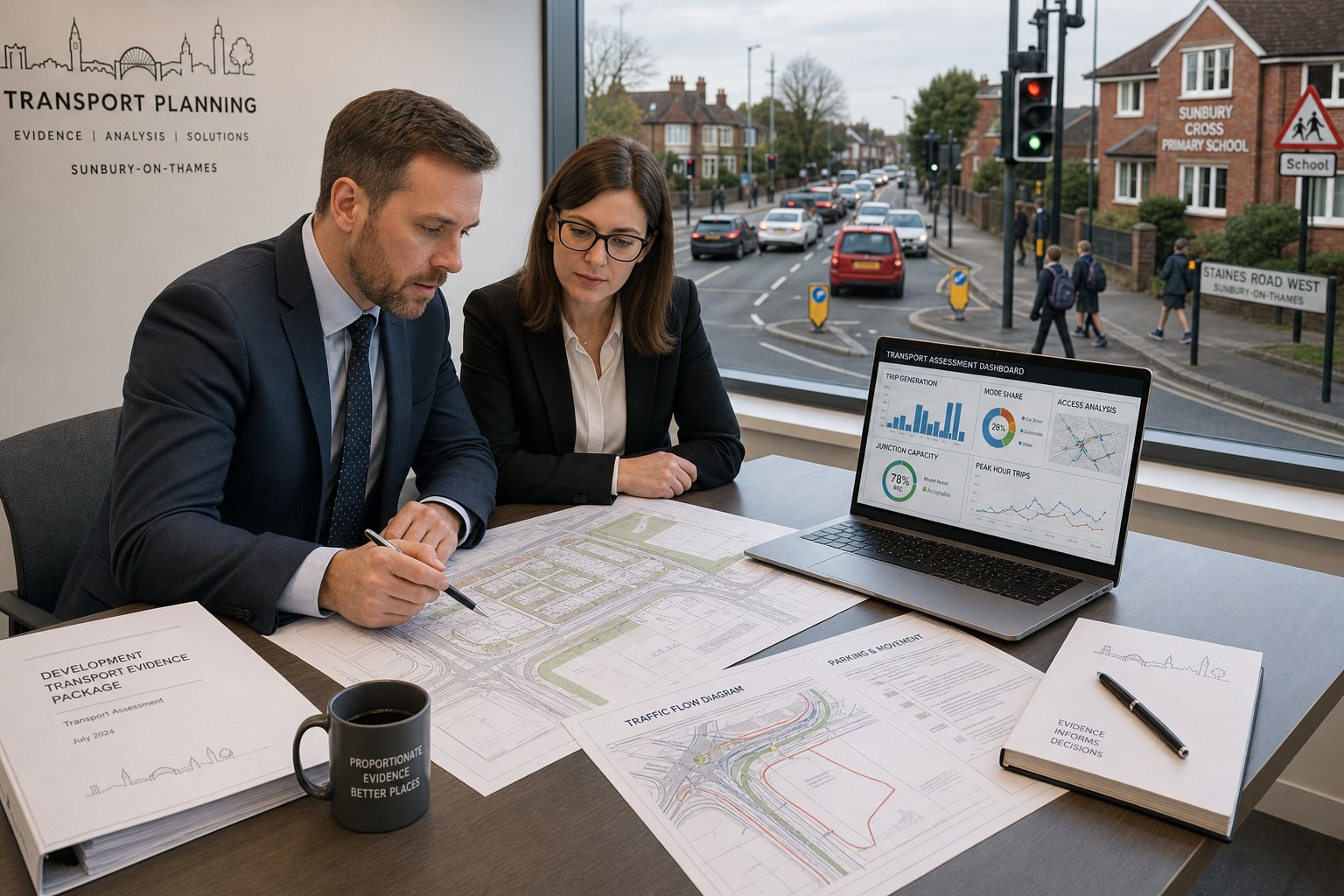
A traffic engineer supporting a Sunbury-on-Thames planning application does far more than produce a report at the end of the design process. We review how a proposal interacts with the surrounding network, identify likely transport concerns early, and assemble technical evidence in a form that planning and highway officers can actually use.
At application stage, that usually means testing the proposal against the National Planning Policy Framework, relevant Department for Transport guidance, Surrey County Council requirements as highway authority, and local planning considerations within Spelthorne. The detail varies by scheme, but the core questions are fairly consistent: will the development create material transport effects, can vehicles and people access the site safely, is parking adequate, and are there mitigation measures needed to make the scheme acceptable?
Typical outputs include Transport Assessments, Transport Statements, access appraisals, parking notes, Travel Plans, junction modelling results, and responses to consultee comments. On more constrained sites, we may also prepare swept path drawings, servicing strategies, collision analysis, construction logistics material and technical rebuttals.
Good transport input is also about timing. If we’re brought in while layouts are still flexible, we can often resolve issues that would otherwise trigger redesign later. That early-stage role is one reason many teams lean on broader Traffic Engineering Consultants: support rather than treating transport as a last-minute validation task.
And, in practice, a strong traffic engineer in Sunbury-on-Thames also acts as translator: turning policy, surveys and modelling into a clear planning narrative that helps officers understand why a scheme should proceed.
When A Transport Assessment Or Transport Statement Is Needed
Not every application in Sunbury needs a full Transport Assessment. But many schemes do need some form of transport evidence, even where the development looks modest on paper.
The usual starting point is scale and use. Residential development, retail proposals, employment schemes, education uses and mixed-use sites can all trigger the need for a TA or TS depending on expected trip generation and local sensitivity. National guidance from the DfT still matters, but local validation requirements and officer judgement often determine what is proportionate in practice.
A Transport Statement is generally suitable where impacts are likely to be limited and can be explained through a concise review of access, parking, sustainable travel and local highway effects. A Transport Assessment is more detailed. It usually includes survey data, trip generation, distribution, assignment, capacity testing and mitigation where required.
The catch is that thresholds are not purely mathematical. A relatively small scheme on a constrained road, near a school, close to a busy junction or within an area already affected by queueing may need more evidence than a larger scheme in a less sensitive location. That’s why we advise teams not to rely on generic national thresholds alone.
For some applicants, a short access note is enough. For others, a scoped package covering TA, Travel Plan and junction modelling is the realistic route. Where there’s uncertainty, early review against local authority expectations and the wider discipline set out in Traffic Engineering: Your Complete often saves weeks later.
How Local Planning And Highway Context Shapes Transport Evidence In Sunbury-On-Thames

Sunbury-on-Thames is not a place where generic transport text works well. Evidence has to reflect the town’s particular geography, commuting pattern and planning context.
Sunbury sits within Spelthorne but is strongly influenced by wider movements towards London, Heathrow and the strategic road network. Add the River Thames, Green Belt constraints, established residential streets and local air quality sensitivities, and you get a transport environment where even small changes in movement can attract close scrutiny. Surrey County Council’s role as highway authority is central here: methodology, survey extents, junction selection and mitigation expectations all need to be aligned with what the authority is likely to accept.
We hence shape reports around real local conditions rather than template assumptions. That includes existing congestion points, walk and cycle connectivity, bus accessibility, school-related peaks, station access patterns, and whether traffic is likely to reroute through nearby residential roads. Comparable work in other authority areas can help with process, but the local lens is decisive: that is why experience across places such as Traffic Engineer In London: settings is useful only when it is translated properly into the Surrey and Spelthorne context.
Key Considerations Around The A308, A244, M3, And Local Network Constraints
The transport case for a Sunbury site often turns on how it relates to a few critical corridors and junctions. The A308 Staines Road East carries significant movement and can be sensitive to additional peak traffic. The A244 corridor, including Cadbury Road and Gaston Bridge Road, also matters for circulation, local access and junction performance. Depending on the site, M3 junction influence may be relevant, particularly where development affects strategic distribution or attracts wider-area vehicle trips.
Beyond the headline roads, there are local pinch points that can be just as important: river crossings, signalised junctions, roundabouts, school frontage conditions, rail level crossing effects and known rat-running routes. Queueing in one location can spill back surprisingly quickly into another. That means survey design and modelling scope need to reflect how the network actually behaves, not just the nearest site access.
Parking, Access, Servicing, And Highway Safety Requirements
Parking and access are often where transport evidence becomes most tangible to decision-makers. Surrey parking standards, disabled bays, electric vehicle charging provision and cycle parking all need to be addressed properly. Under-provision can create overspill concerns: over-provision can undermine sustainability arguments. The right answer depends on use, layout and local context.
Access design needs to show safe visibility splays, acceptable gradients, turning arrangements and practical day-to-day operation. Refuse collection, service vehicles and emergency access should not be left vague. We also review pedestrian routes, crossing opportunities and the relationship between vehicle movements and vulnerable users.
Highway safety work may include collision review, site observations and design checks against relevant standards. Where servicing is tight or access geometry is awkward, combining the written case with Traffic Engineer In Leeds: style planning-led transport analysis is helpful in showing not just that a layout works, but why it works safely in operational terms.
Transport Assessments For Residential Development
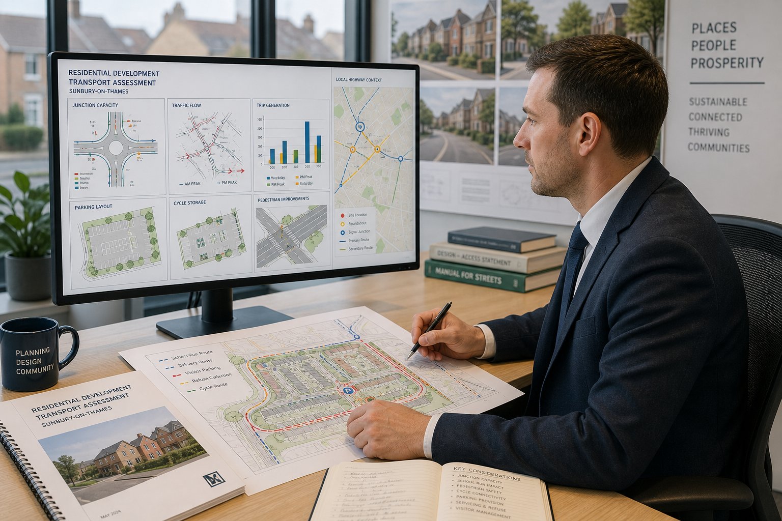
Residential development in Sunbury-on-Thames tends to bring a familiar set of transport questions, but the answer is never quite off-the-shelf. Officers will want to understand not only how many vehicle trips a scheme is likely to generate, but when those trips occur, where they go, how they affect nearby junctions and whether the layout supports safe, practical travel choices.
A residential Transport Assessment usually starts with the baseline: traffic counts, site observations, sustainable transport review and a record of existing constraints. We then establish trip generation, commonly using TRICS with careful selection of comparable sites rather than broad-brush averages. Distribution and assignment follow, informed by local movement patterns, strategic links and likely destinations for work, school, retail and leisure.
For smaller schemes, that may be enough. For larger or more sensitive proposals, junction capacity modelling becomes central. Peak-hour performance, queue lengths and reserve capacity at nearby priority junctions, roundabouts or signals often shape the discussion with the highway authority.
Residential work also needs a robust parking strategy. That includes allocated and visitor spaces, cycle storage, disabled provision and the risk of overspill onto already pressured streets. Just as important are walking and cycling links, public transport accessibility and opportunities for mitigation, whether through improved crossings, local highway amendments, TROs or proportionate financial contributions.
We’ve found that the most persuasive residential assessments are the ones that recognise daily life on the site: school runs, delivery activity, refuse collection, visitors arriving at awkward times, and the way one badly arranged turning head can unravel an otherwise good scheme.
Transport Input For Commercial, Industrial, And Mixed-Use Schemes
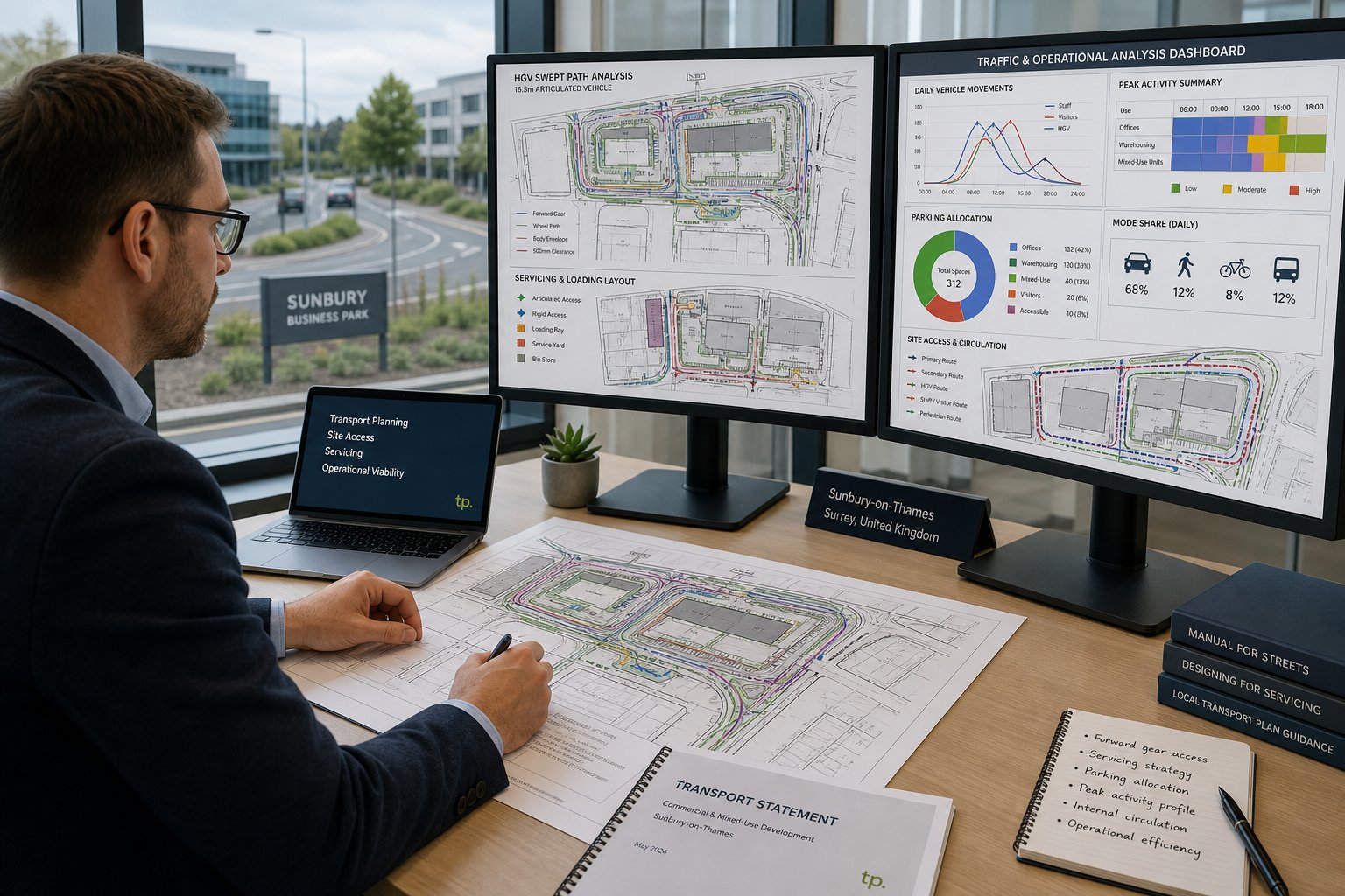
Commercial and employment-led proposals usually demand a different level of scrutiny from residential schemes, especially where servicing and HGV activity are involved. In Sunbury-on-Thames, that matters because local roads can feel relatively ordinary until a site starts generating regular deliveries, shift changes or larger vehicle movements.
For offices, industrial units, trade counters, warehousing and mixed-use projects, we examine trip profiles across the day rather than focusing only on a standard commuter peak. Shift overlap, delivery windows, staff arrivals, customer visits and contractor traffic can create very different network effects. Industrial proposals, in particular, need clear evidence on HGV routing, loading arrangements, internal circulation and whether vehicles can enter and leave in forward gear.
Mixed-use schemes add another layer. Shared parking, staggered peaks and linked trips can be beneficial, but only if the assumptions are realistic and well explained. A weak cumulative assessment is one of the quickest ways to attract highway queries.
Servicing strategy is often the hinge point. Loading bays that work on a drawing but block circulation in practice won’t satisfy officers for long. The same goes for abnormal loads, refuse collection and visitor coach or van activity where relevant. For developer teams dealing with these issues regularly, the broader lessons from Commercial Traffic Engineering are directly relevant: operational detail matters just as much as headline trip totals.
In short, the transport case for commercial land uses has to prove the site functions in the real world, not merely that average daily traffic appears manageable.
Travel Plans, Trip Generation, And Junction Capacity Modelling
These three elements are often grouped together in planning discussions, but each plays a distinct role in getting an application over the line.
Trip generation is the foundation. If the forecast is poorly evidenced, every later conclusion becomes vulnerable. We generally use TRICS selectively, sense-check outputs against local context, and explain why the chosen comparators are suitable. For mixed or unusual uses, that explanation can matter as much as the numbers themselves.
Travel Plans sit slightly differently. They are part technical document, part management tool. A good Travel Plan sets out realistic mode-share objectives, practical measures, monitoring arrangements and responsibilities. In Sunbury, the credibility of a Travel Plan often depends on the actual travel choices available from the site: bus access, station distance, walking routes, cycle infrastructure, secure parking and end-of-trip facilities. If those ingredients are weak, lofty sustainable mode targets won’t carry much weight.
Then there’s capacity modelling. Where a development affects nearby junctions, we may use industry-standard tools such as PICADY, ARCADY or LINSIG to test operation in future-year scenarios, with and without development traffic. Queue length and delay can be just as important as RFC or degree of saturation, particularly on constrained local roads where practical driver experience matters.
It’s worth saying this plainly: modelling is not there to impress anyone. It is there to answer focused planning questions. Good modelling simplifies decisions: bad modelling creates debates about inputs and assumptions. That principle applies whether the scheme is in Sunbury or in other authority contexts such as Traffic Engineer In Manchester: areas where local network behaviour equally drives the final judgment.
Swept Path Analysis And Vehicle Tracking For Site Access Design
Some planning applications rise or fall on a single practical question: can the vehicles that need to use the site actually do so safely and efficiently? That’s where swept path analysis becomes essential.
Using vehicle-tracking software such as AutoTrack or similar tools, we test how specific design vehicles move through accesses, internal roads, bends, loading areas and turning heads. In Sunbury-on-Thames, this is particularly important on tighter urban plots, backland sites, redevelopment land with legacy constraints, and schemes where visibility or frontage width is limited.
The design vehicle has to reflect reality. For housing, that might include refuse vehicles and fire appliances. For commercial sites, vans, rigid HGVs or articulated vehicles may be necessary. It’s not enough to show a vehicle can technically squeeze through if that movement relies on mounting footways excessively, conflicting with waiting vehicles, or making awkward repeated shunts.
Swept path work also supports discussions about access width, gate positions, parking layout, bin collection points and whether servicing can happen on-site rather than from the carriageway. When done early, it often prevents expensive redesign. When left late, it tends to expose avoidable problems.
We usually pair the drawings with concise explanation, because officers and project teams need to understand the operational implication, not just the linework. A neat tracking plot is useful: a tracking plot tied to highway safety and workable daily management is what really moves the application forward.
Construction Logistics, Delivery Management, And Temporary Traffic Impacts
Temporary transport effects can generate just as much resistance as the completed development, especially on constrained roads or near sensitive neighbours. In Sunbury, where residential streets, schools and busy corridors sit close together, construction traffic management often needs more than a token paragraph.
A Construction Logistics Plan typically addresses HGV routing, contractor parking, delivery booking, hours of operation, wheel washing where needed, temporary traffic management, pedestrian protection and communication procedures. The aim is to show that build-out can happen without creating unreasonable safety or amenity problems.
For occupied developments, Delivery and Servicing Plans can be equally important. These set out how deliveries will be timed and managed once the site is operational, helping to avoid repeat conflict with peak traffic, school arrival times or neighbouring frontages.
The planning value here is simple: temporary impacts become much easier for authorities to accept when they are anticipated and controlled. Vague promises to “manage construction responsibly” don’t do much. Specific routing plans, restrictions on larger vehicles, marshal arrangements, and details on footway closures or temporary loading controls do.
We also look at whether construction phasing changes the traffic picture. A scheme delivered in stages may create short-term network effects that differ materially from the final arrangement. That kind of realism is often what separates a credible logistics document from a box-ticking one, and it’s a point that strong Traffic Engineer In Birmingham: style planning support also tends to handle well.
Supporting Planning Appeals, Objections, And Highway Responses
Even well-prepared schemes can run into transport objections. Sometimes the issue is technical. Sometimes it’s a disagreement over judgment, proportionality or the interpretation of limited evidence. Either way, the response needs to be precise.
When supporting an appeal or rebutting a highway objection, we start by isolating the real point in dispute. Is the authority saying the trip generation is underestimated? That junction modelling is incomplete? That the access is unsafe? Or that the mitigation offered is insufficient? The answer shapes everything that follows.
We prepare technical notes, revised assessments, formal rebuttals and, where necessary, expert evidence for hearings or inquiries. The strongest appeal work is usually not the loudest. It is the clearest: identify the allegation, test it against data and policy, and explain why the scheme is or is not acceptable.
The same skills apply when acting for third parties raising transport objections. A credible objection letter needs evidence, not just local frustration. Collision history, visibility concerns, swept path failures, parking displacement risk and cumulative effects can all be legitimate points if handled properly.
Highway responses from Surrey County Council also benefit from direct, professional engagement. A short conversation to clarify survey scope or modelling assumptions can avoid pages of unnecessary dispute. In many cases, progress comes from narrowing disagreement rather than trying to win every point.
What To Prepare Before Instructing A Traffic Engineer
Projects move faster when the transport brief starts with the right information. We don’t need every detail fixed, but a traffic engineer can only advise properly if the basics are clear.
At minimum, it helps to provide the red-line boundary, a draft site layout, proposed land use, floorspace or unit numbers, anticipated servicing needs and the intended programme for submission. If phasing is likely, say so early. A phased scheme may require different assumptions, survey strategy or mitigation logic.
Previous planning history is also valuable. Old highway comments, refused layouts, committee concerns or appeal findings often reveal the authority’s likely focus. The same goes for known local issues: school traffic, informal parking, neighbour complaints, rat-running or access restrictions. Sometimes a five-minute explanation from the design team saves days of back-and-forth later.
We also recommend sharing any existing topographical information, speed survey data, collision concerns, public transport material and contact details for the wider consultant team. Transport work rarely sits in isolation: it touches drainage, landscape, refuse strategy, fire access and urban design more than people expect.
If the goal is a fast planning submission, be candid about deadlines. A realistic programme allows survey booking, analysis, drawing coordination and, where appropriate, pre-application input. Rushed instructions can still be managed, of course, but the best results come when transport evidence is allowed to shape the scheme rather than chase it.
Choosing A Traffic Engineer For Sunbury-On-Thames Projects
Choosing the right consultant is not just about finding someone who can write a Transport Assessment. It is about finding someone who can judge what level of evidence is proportionate, spot local risk early, and communicate effectively with officers, planners and the rest of the project team.
For Sunbury-on-Thames, we’d look for a traffic engineer with solid UK transport planning experience, preferably chartered or working within a senior-led team, and with a track record in Surrey, Spelthorne or comparable authorities. Local familiarity matters because report quality is only part of the equation: knowing how authorities typically approach survey scope, parking standards, access design and mitigation discussions can materially reduce delay.
Capability should cover the full spread, not just one report type: TA/TS work, Travel Plans, junction modelling, swept path analysis, servicing reviews and construction logistics. Equally important is clarity. A technically correct report that buries the key planning points under dense text won’t help your application much.
We also think responsiveness matters more than many teams admit. Planning timetables rarely wait politely. Consultant teams need concise answers, practical recommendations and a willingness to liaise directly with Surrey County Council and Spelthorne officers where needed.
That’s the standard we aim for in our own work at ML Traffic: concise, accurate transport evidence delivered quickly and shaped around the authority context rather than generic templates. For teams comparing wider regional experience, examples from Traffic Engineer In Bristol: and similar location-specific work show why local planning nuance, not just technical competence, is what usually drives faster project progress.
A good traffic engineer in Sunbury-on-Thames should make the planning route feel clearer. If the advice makes the scheme more certain, more defensible and easier to explain, you’re probably talking to the right team.
Frequently Asked Questions About Traffic Engineering in Sunbury-on-Thames
What role does a traffic engineer play in planning applications in Sunbury-on-Thames?
A traffic engineer reviews how development proposals interact with Sunbury’s local transport network and policies, producing Transport Assessments, access appraisals, travel plans, and responding to highway consultations to support planning applications effectively.
When is a Transport Assessment or Transport Statement required for Sunbury-on-Thames projects?
A Transport Assessment or Transport Statement is needed based on the scale and use of the development, considering trip generation and local sensitivity, following Department for Transport guidance and Surrey County Council’s local requirements.
How do local road conditions in Sunbury-on-Thames influence transport evidence requirements?
Transport evidence must reflect Sunbury’s proximity to London, Heathrow, key corridors like the A308 and A244, congestion points, school traffic, and the role of Surrey County Council as highway authority to meet local planning expectations.
What parking and access considerations must a traffic engineer address in Sunbury-on-Thames?
They ensure compliance with Surrey parking standards including disabled and EV spaces, safe visibility splays, gradients, service access, pedestrian and cycle routes, and review collision history to support safe and practical site operation.
How does swept path analysis support planning applications in Sunbury-on-Thames?
Swept path analysis uses vehicle tracking software to verify that design vehicles like refuse trucks, fire appliances, and HGVs can safely manoeuvre through site accesses and internal roads, preventing costly redesign and ensuring highway safety.
What should developers prepare before instructing a traffic engineer for a Sunbury-on-Thames project?
Developers should provide red-line boundaries, draft layouts, proposed land uses and floorspace, phasing plans, previous highway comments, known local transport issues, and a realistic submission programme to enable effective transport assessment.