North Watford schemes rarely fail on design ambition alone. More often, they get slowed down by practical questions: will the access work, can the local junction cope, is parking realistic, and has the transport case been evidenced properly? Those issues matter whether we’re advising on a small change of use near a local centre or a more complex residential or mixed-use proposal feeding onto a busier corridor.
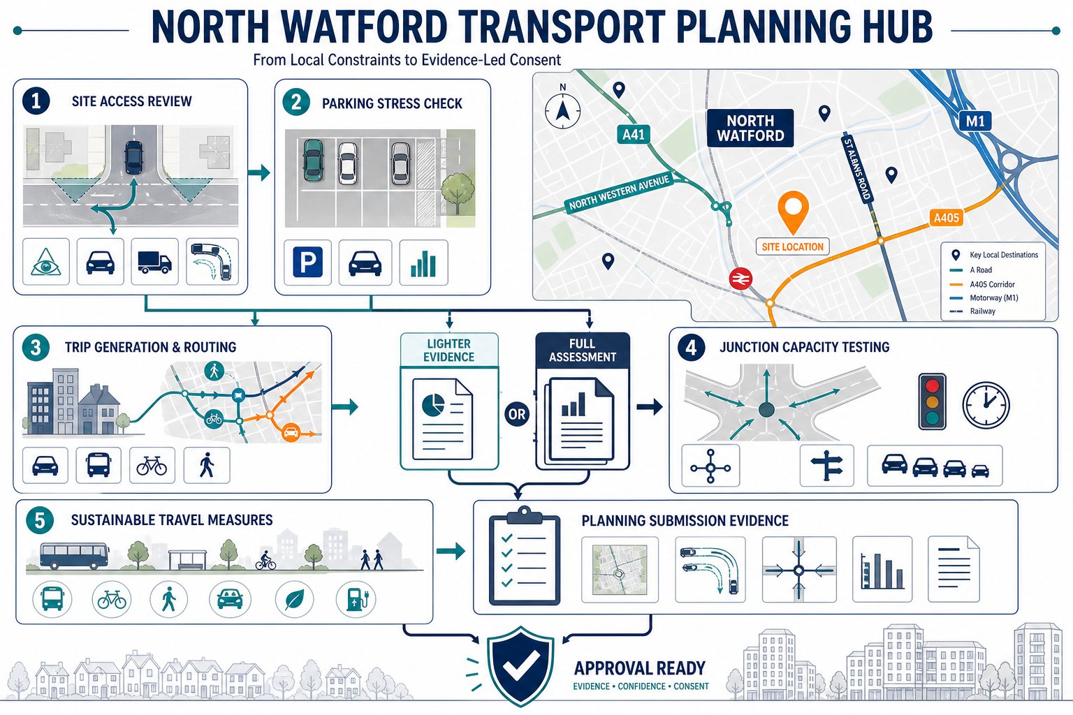
That is where a Traffic Engineer In North Watford becomes central to the planning process. In this part of Watford, transport isn’t just a technical appendix. It can shape site layout, influence unit numbers, determine whether a servicing strategy is acceptable, and affect how Hertfordshire County Council, as highway authority, responds to an application. Roads such as the A41, North Western Avenue and St Albans Road, together with links toward the M1 and A405, create a context where even modest traffic changes can attract scrutiny.
Our role is to turn that scrutiny into a clear, proportionate evidence base. That usually means transport assessments or statements, access reviews, trip generation work, parking analysis, swept path checks, and, where needed, junction modelling. Done well, this work reduces uncertainty early, helps planning teams respond to policy and local thresholds, and gives decision-makers confidence that a proposal can operate safely and acceptably in 2026 and beyond.
Key Takeaways
- A Traffic Engineer in North Watford plays a crucial role in ensuring transport evidence is accurate and influences planning strategy effectively from the start.
- Transport assessments must be proportionate and locally specific, addressing access feasibility, parking, trip generation, and junction impacts to satisfy Hertfordshire County Council requirements.
- Early engagement with local planning and highway authorities streamlines applications and helps tailor transport reports to reduce objections and delays.
- Access design and visibility checks are vital to safe site operations; early integration of these factors prevents costly redesigns and strengthens planning cases.
- Transport evidence should clearly demonstrate safe access, manageable network impact, and compliance with local policies to secure smooth planning consent in North Watford.
- Travel Plans and parking reviews support sustainable transport goals and can justify reduced parking provision when backed by solid evidence reflecting actual site conditions.
Why A Traffic Engineer Matters For North Watford Developments
North Watford presents a very specific transport planning environment. Development sites are often influenced by strategic traffic movements, constrained frontage conditions, nearby residential streets, bus routes, school travel patterns and existing parking stress. In practice, that means transport evidence cannot be generic. It needs to reflect how people actually move around the site and how the network performs at the times that matter.
A competent traffic engineer helps frame that evidence from the start. We identify likely planning triggers, review access feasibility, test whether the proposal is likely to raise concerns from Hertfordshire County Council, and advise the wider consultant team before an application is fixed in the wrong shape. That early input can save months. A scheme that looks fine on a block plan can become problematic if refuse tracking fails, visibility is restricted, or parking overspill appears inevitable.
For architects, planners and developers, the value is not just technical accuracy. It is strategy. We align reports with local policy, likely officer concerns and proportionality. That is especially important where applications need to show that residual cumulative impacts would not be severe, that sustainable modes are genuinely available, and that highway safety has been properly considered. Broader best practice used by Traffic Engineering Consultants: What and wider Highway And Traffic Engineering teams applies here, but North Watford still demands local judgement.
The Role Of Transport Evidence In Planning Applications
Transport evidence gives planning officers and highway officers a structured basis for decision-making. Without it, assumptions take over, and assumptions usually work against the applicant.
At application stage, that evidence may include a Transport Assessment, Transport Statement, access appraisal, parking survey, swept path analysis, trip generation calculations, delivery and servicing input, travel planning measures and junction capacity modelling. Each document answers a different question. Together, they show whether the proposal is safe, suitable and policy-compliant.
Good evidence also narrows debate. Instead of broad objections about “more traffic”, we can focus on measurable impacts: peak-hour trips, likely routing, visibility splays, parking demand, cycle provision, pedestrian connectivity and operational effects on nearby junctions. That is the difference between a vague application and one with a defendable transport case.
Local Transport And Highway Considerations In North Watford
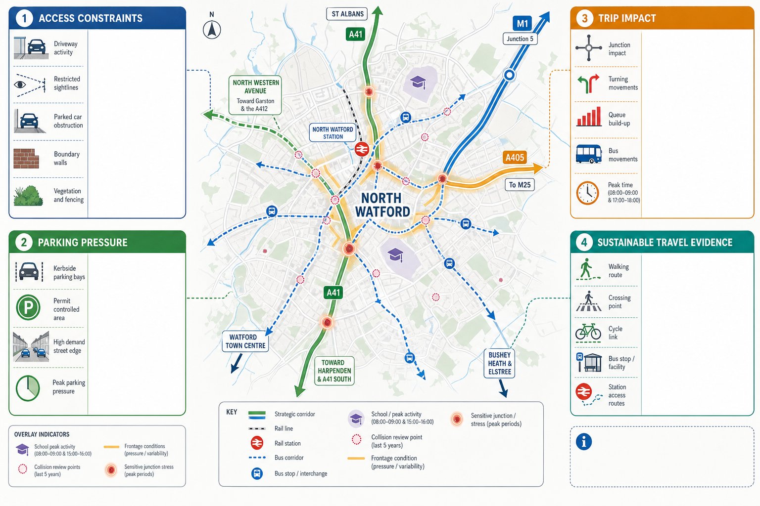
North Watford is not assessed in isolation. Its schemes sit within a network influenced by strategic corridors, local distributor roads, rail access, schools, neighbourhood centres and established residential parking patterns. A site may appear modest in scale but still connect to a sensitive movement corridor or a stressed local junction.
In many cases, the A41 corridor and links toward North Western Avenue, St Albans Road, the A405 and the M1 shape the discussion. Highway officers will often want reassurance that a proposal does not create unacceptable local effects that spill into those wider routes, particularly where turning movements, queueing or access friction could affect network operation. Equally, proximity to Watford North station or established bus services can support a sustainable transport argument, but only if pedestrian routes are direct, safe and realistic.
For planning teams, this means transport strategy has to be site-specific. We typically review nearby collision history, frontage conditions, crossing opportunities, bus stop accessibility, cycling links, school-related peaks and existing parking controls. On larger or more exposed sites, a methodology similar to Commercial Traffic Engineering work can be useful because operational impacts, servicing and peak spreading often become central to the acceptability case.
Common Constraints Affecting Access, Parking, And Trip Impact
The most common North Watford constraints are not mysterious: they are just easy to underestimate.
First, access. Many sites have limited frontage, nearby junctions, boundary walls, vegetation, parked vehicles or carriageway alignment issues that restrict visibility. A technically possible access is not always a policy-compliant one.
Second, parking. Existing on-street demand can be high, especially near local centres, schools and public transport corridors. Where a development proposes reduced parking, it needs a credible justification rooted in accessibility, likely car ownership and active management measures.
Third, trip impact. Even smaller schemes can attract scrutiny where they load onto already busy junctions, interfere with bus movement, or create turning conflicts. Net new demand matters, but so does timing. School peaks, commuter peaks and servicing windows can all sharpen impacts.
Finally, sustainable mode claims need evidence. Saying a site is “walkable” is not enough: decision-makers usually want to understand route quality, crossing provision, gradients, surveillance and journey realism.
Transport Assessments And Statements For Planning Submission
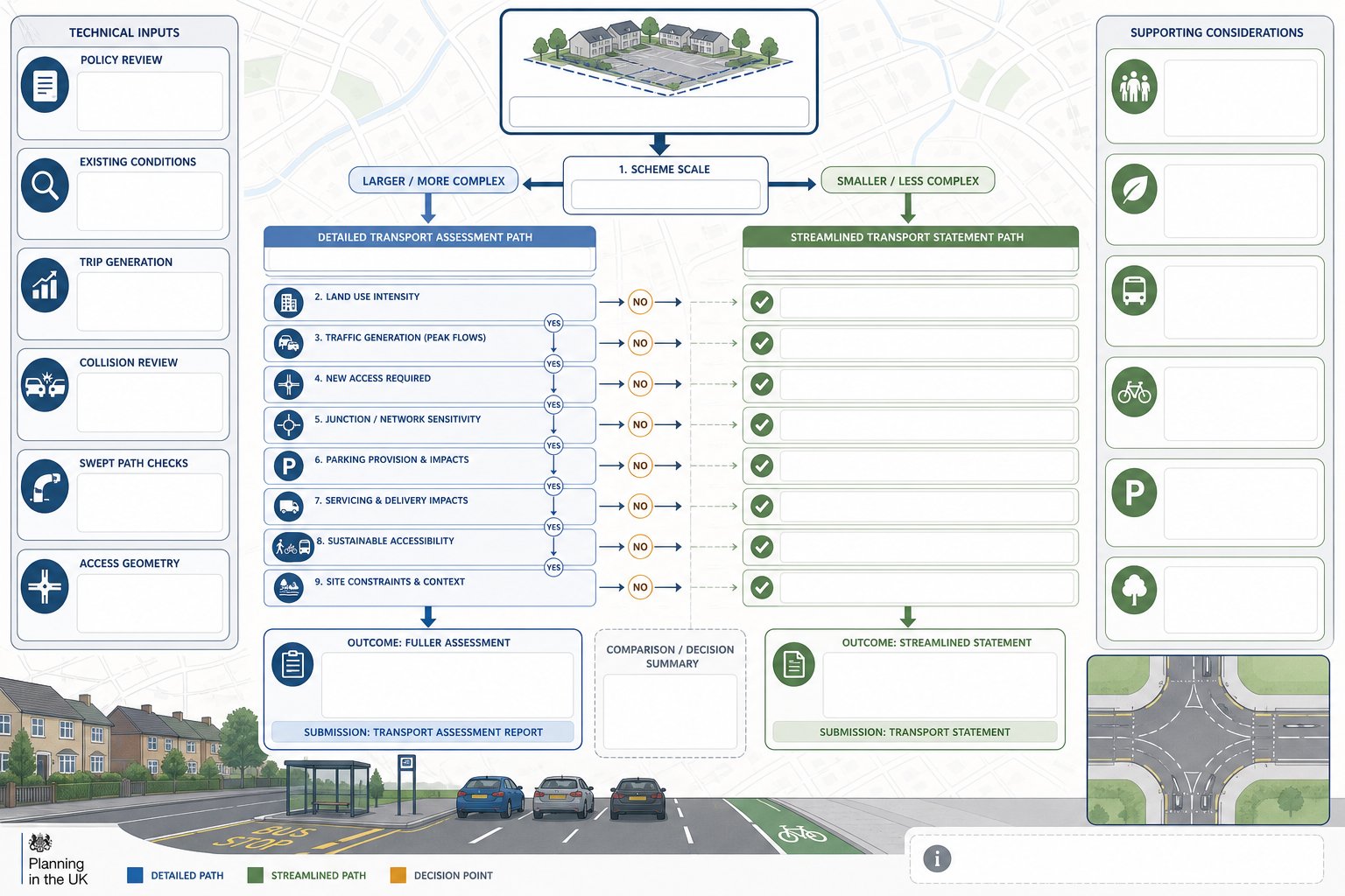
For most planning applications, the transport question is not whether evidence is needed but what level of evidence is proportionate. That is where many submissions go wrong. Some applicants over-produce material that obscures the real issues. Others submit too little and invite requests for more information, delays or objections.
A well-prepared transport report should match the scale, land use and sensitivity of the proposal. It should explain the site context, review policy, describe existing conditions, estimate trip generation, assess sustainable accessibility, consider parking and servicing, and deal with access arrangements. If relevant, it should also address collision records, delivery activity, swept paths and junction operation.
We usually advise that the report is prepared alongside layout development, not after it. That way, design and evidence inform each other. A parking layout can be tested before it becomes fixed. A servicing route can be corrected before planning drawings are issued. If access geometry is marginal, the team can respond early rather than after validation.
This is the same disciplined approach we apply across regions, whether a scheme needs Traffic Engineer In London: style urban sensitivity or the more suburban context reflected by Traffic Engineer In Bristol: work. Local thresholds differ, but the principle is constant: proportional, robust evidence wins time.
When A Full Assessment Is Needed Versus A Proportionate Statement
A full Transport Assessment is generally needed where a scheme is larger, more traffic-intensive, access-led, or likely to affect sensitive junctions or strategic routes. Examples include substantial residential developments, mixed-use schemes with notable peak-hour trip generation, proposals creating a new access onto a busier road, or applications near constrained junctions where capacity is already an issue.
A Transport Statement is usually appropriate for smaller developments with modest and broadly manageable impacts. It still needs evidence, but the scope is lighter. We would normally expect concise trip generation, parking review, sustainable accessibility commentary, access checks and a clear statement on why impacts are not significant.
The difference is not simply scheme size. Site sensitivity matters just as much. A small proposal on a constrained frontage near a stressed junction may need more analysis than a larger one in a forgiving location. That is why early scoping with the local authority can be so valuable.
Travel Plans, Parking Reviews, And Sustainable Transport Measures
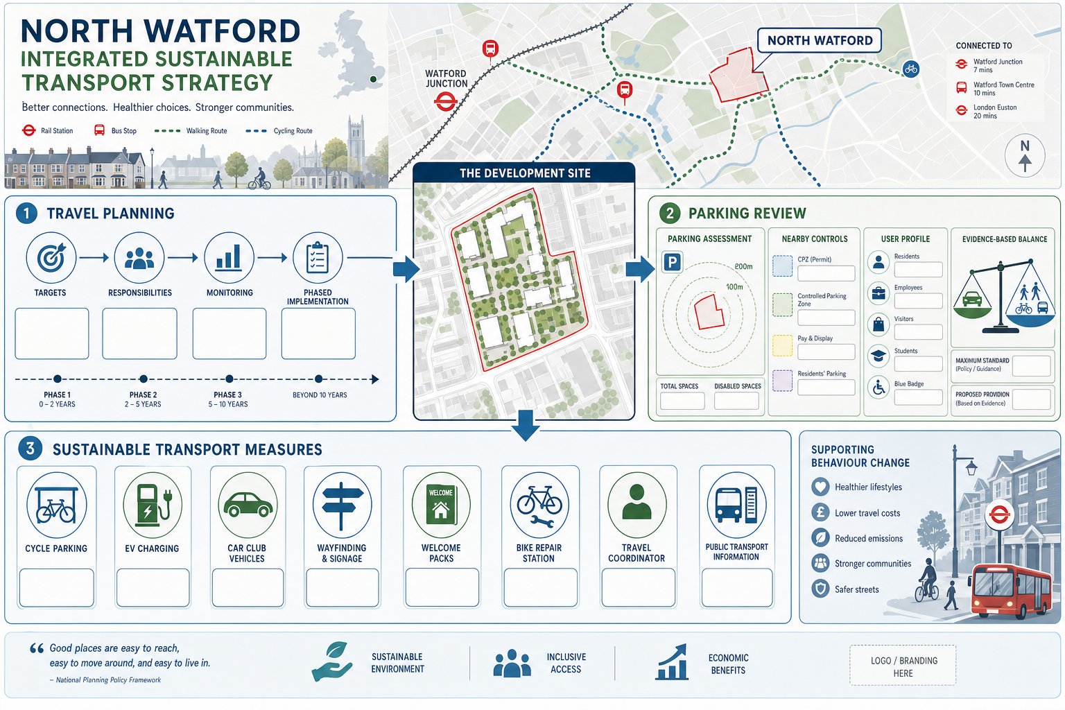
Travel Plans are often treated as paperwork. They shouldn’t be. In the right form, they help demonstrate that the transport strategy behind a scheme is practical, policy-aware and capable of reducing reliance on private car travel over time.
In North Watford, this can be particularly important where parking provision is tight, where the site sits near bus or rail services, or where the planning authority expects stronger support for walking, cycling and public transport. Depending on the scheme, a Framework Travel Plan may be sufficient at outline or early stage, while a full Travel Plan may be expected for larger residential, education, employment or mixed-use proposals.
A good Travel Plan is specific. It sets targets, identifies measures, names responsibilities and establishes monitoring. Typical measures include welcome packs, cycle parking, EV charging, car club provision, public transport information, pedestrian wayfinding, cycle repair facilities, travel coordinators and incentives tied to occupation stages.
Parking reviews sit alongside that work. We compare the proposal against local standards, then assess whether any deviation is reasonable considering accessibility, likely user profile, nearby controls and site constraints. When reductions are justified, the explanation needs to be evidence-led rather than aspirational. Wider principles from Traffic Engineering: Your Complete and practical access design highway guidance often overlap here, especially where parking layout and movement strategy need to work together.
Highway Access Design And Visibility Requirements
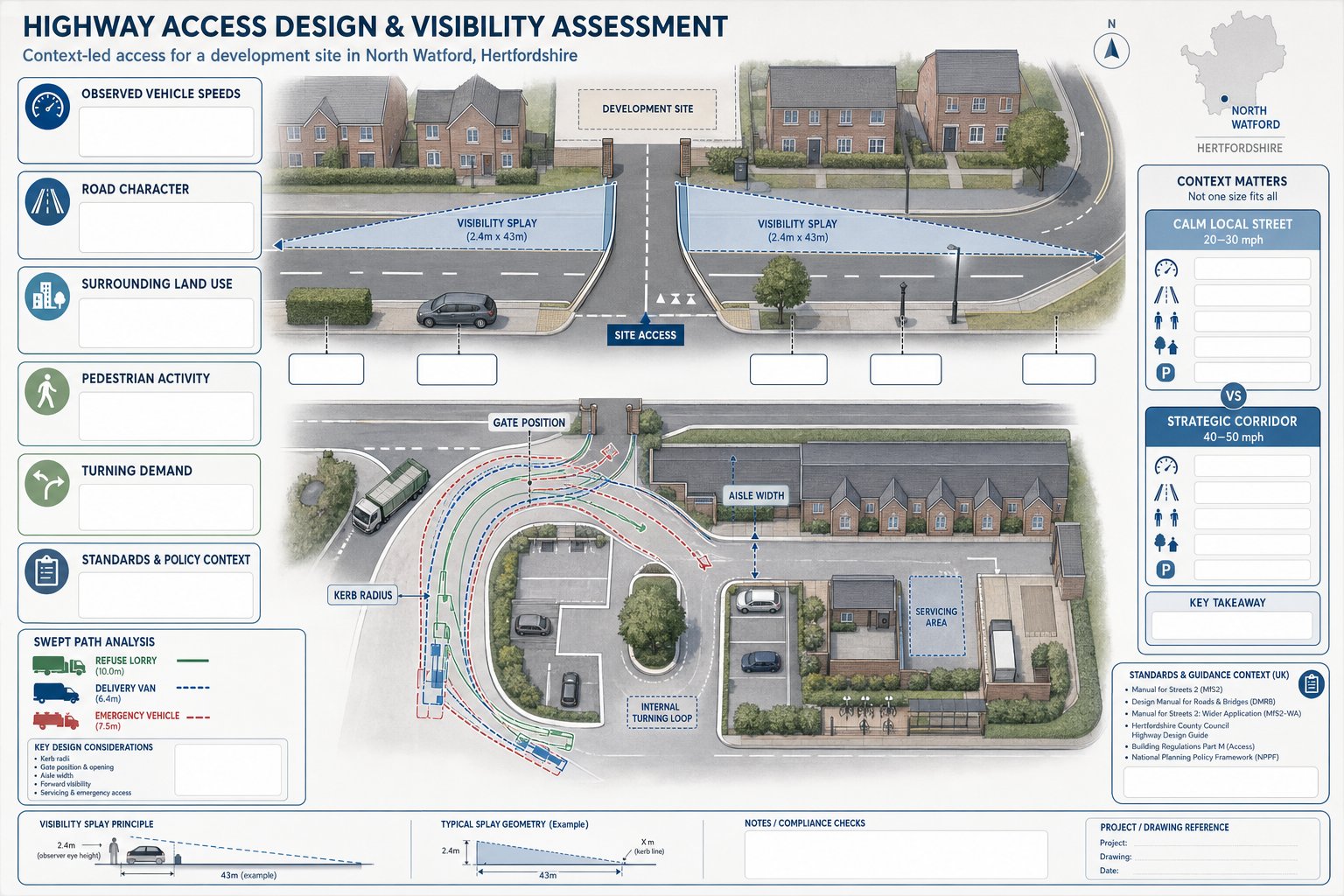
Access design is one of the fastest ways for a planning application to run into trouble. If vehicles cannot enter and leave safely, if refuse or delivery movements are awkward, or if visibility is substandard without mitigation, the rest of the transport case becomes much harder to defend.
For North Watford sites, we assess access against the character of the road, observed vehicle speeds, surrounding land use, pedestrian activity and the likely level of turning movement the development will generate. Design principles commonly draw on Manual for Streets and, where appropriate, DMRB-related standards, but context matters. A lower-speed urban street does not require the same response as a more strategic corridor.
Visibility splays are a recurring issue. Boundary treatments, street furniture, trees, parked cars and road alignment can all compromise them. In some cases, a scheme can be redesigned to improve the outcome. In others, the geometry or land control makes compliance difficult, and the application strategy has to confront that honestly.
We also review tracking for refuse vehicles, emergency access, servicing and internal turning. For residential and mixed-use developments, that often affects building siting and courtyard design. Seemingly minor tweaks to kerb radii, gate positions or aisle widths can determine whether an application feels resolved or risky.
This is why access work should not be left until the end. When it is integrated early, the layout has a far better chance of surviving consultation without significant redesign.
Junction Capacity, Trip Generation, And Traffic Modelling
Once a scheme’s access is workable, the next question is usually operational impact. How many trips will the development generate? Where will they go? And will nearby junctions continue to function acceptably?
Trip generation normally begins with TRICS, combined with local judgement about land use, location, public transport accessibility, parking restraint and comparable development patterns. That matters because raw database outputs can mislead if they are not filtered carefully. A North Watford site near bus services and rail may perform differently from a more isolated location, even for the same use class.
From there, we distribute and assign trips using the surrounding network, likely desire lines and observed route choice. If the resulting impacts are modest, a qualitative review may be enough. If not, we move into capacity testing using standard tools such as PICADY, ARCADY or LINSIG, depending on junction type.
The point of modelling is not to create complexity for its own sake. It is to answer practical planning questions: will queues materially worsen, are there reserve capacity concerns, does a right-turn manoeuvre create friction, and is mitigation needed? In North Watford, that can be especially relevant on routes feeding strategic corridors or where local junctions are already sensitive during commuter and school peaks.
Well-presented modelling also helps negotiations. Officers may still challenge assumptions, but they are responding to a transparent method rather than broad claims. And that usually produces a faster route to an agreed position.
Supporting Change Of Use, Residential, And Mixed-Use Schemes
Different scheme types need different transport narratives. Treating them all the same is a common mistake.
For change of use proposals, the key issue is often the net effect. What was the lawful or established use generating before, and what is proposed now? If the replacement use creates fewer peak trips or similar parking demand, that can materially strengthen the planning case. But it must be evidenced properly, particularly where the existing use is not active or where its traffic profile is disputed.
Residential schemes usually require a broader review. We look at car and cycle parking, internal movement, refuse collection, visitor management, servicing, pedestrian permeability, accessibility to local facilities and cumulative impact on nearby streets. Family housing, flats and specialist accommodation can all generate different travel patterns, so assumptions should reflect the actual product.
Mixed-use developments are more nuanced again. Uses can complement one another through linked trips and internal capture, but they can also create competing peaks, servicing pressure and more complex access arrangements. In those cases, a single transport report needs to explain how the parts work together, not just independently.
Across all three categories, early transport advice can influence site yield and layout in a positive way. That is often the difference between a scheme that merely submits and one that stands up to scrutiny from planners, highway officers and, where necessary, appeal inspectors.
Working With Local Planning Authorities And Highway Officers
A technically sound report can still struggle if the process around it is poor. In North Watford, pre-application engagement often makes a real difference, especially for sites with new access points, sensitive parking issues, or potential effects on busy corridors.
We generally recommend early dialogue with Watford Borough Council and Hertfordshire County Council’s highway team to agree scope, baseline assumptions, survey needs and the likely level of reporting. That does not guarantee agreement later, but it reduces the chance of fundamental objections based on missing evidence or the wrong methodology.
The most productive discussions are usually specific. Which junctions should be assessed? Is a parking stress survey likely to be expected? What committed development should be included? Is a Travel Plan required? Could a Transport Statement be accepted in place of a full Assessment? These are manageable questions when raised early: they become delays when raised after submission.
This stage is also where mitigation is often shaped. Officers may seek access amendments, localised waiting restrictions, walking and cycling improvements, monitoring clauses, or contributions through Section 106 or works under Section 278. Practical experience from a Traffic Engineer In Manchester: context or another urban authority can be useful, but successful negotiation in Watford still depends on local policy reading, concise technical responses and credible compromise.
With more than 30 years of combined experience reflected in our work, we have found that concise, accurate reporting usually carries more weight than oversized documents. Officers want clarity, not theatre.
Conclusion
For 2026 projects, appointing the right Traffic Engineer In North Watford is not just about producing a report to tick a box. It is about shaping a planning strategy that can withstand technical scrutiny from the outset.
Where transport evidence is proportionate, locally aware and integrated into the design process early, applications tend to move more smoothly. Access issues are addressed before they harden into objections. Parking and trip impacts are explained with confidence. And discussions with planning and highway officers become more focused and constructive.
For architects, planners, lawyers, developers and councils, that matters. North Watford can present strategic road sensitivities, constrained frontages and real parking pressure, but those challenges are manageable when the evidence is prepared properly. The goal is simple: demonstrate safe access, acceptable network impact, policy compliance and a credible route to consent.
Frequently Asked Questions About Traffic Engineering in North Watford
What role does a traffic engineer play in North Watford developments?
A traffic engineer in North Watford provides essential transport evidence and advice to ensure proposals operate safely on local and strategic roads like the A41, helping align schemes with Hertfordshire Local Transport Plan and Watford planning policies.
When is a full Transport Assessment required instead of a Transport Statement in North Watford?
A full Transport Assessment is generally needed for larger or more traffic-intensive schemes affecting sensitive junctions or strategic routes, while a proportionate Transport Statement suits smaller developments with modest, manageable impacts.
How does transport evidence influence planning applications in North Watford?
Transport evidence, including assessments, travel plans, and modelling, supports planning decisions by quantifying trip generation, parking needs, access design, and ensuring compliance with local highway policies for safe, acceptable developments.
What common constraints affect access and parking for developments in North Watford?
Typical constraints include limited road frontage reducing visibility, high on-street parking demand near centres or schools, and sensitive junction capacities that may impact bus reliability and local safety.
How can early engagement with local authorities improve traffic engineering outcomes in North Watford?
Pre-application discussions with Watford Borough Council and Hertfordshire County Council’s highway team help define evidence scope, agree survey needs, and mitigate potential objections, speeding up planning approval processes.
What sustainable transport measures might a traffic engineer recommend for a North Watford development?
Recommended measures include EV charging points, car club schemes, improved walking and cycling links, cycle parking, travel plans with monitoring, and public transport incentives to reduce private car reliance.