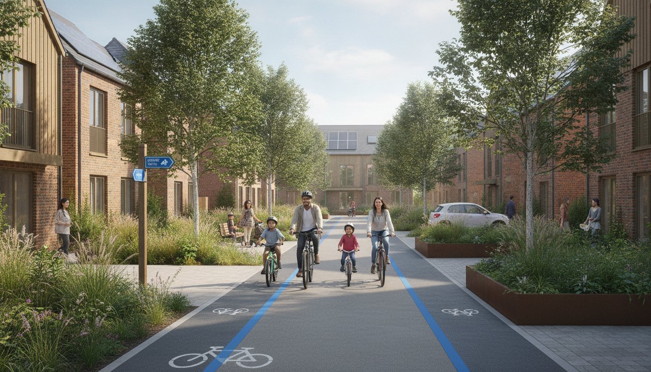
How do you secure planning approval for a high-density development when local authorities demand that 70% of all trips occur via sustainable modes? Achieving this target requires more than just drawing cycle lanes on a map; it demands a fundamental shift from traditional “predict and provide” models to a vision-led approach. Success hinges on a robust garden neighbourhood transport strategy and placemaking framework that prioritizes human movement over vehicle throughput. With 88% of English Local Highway Authorities now supporting 20mph design speeds for residential streets as of May 2026, the regulatory environment has moved firmly toward people-centric design.
You likely recognize the complexity of balancing multi-modal transport assessments with the need for vibrant, walkable spaces. We’ve developed this guide to help you master the technical requirements and placemaking principles necessary to navigate these high-stakes regulatory hurdles. You’ll learn how to align your project with the April 2026 Local Transport Plan guidance and utilize data-driven strategies to reduce logistical pressures. This article previews the essential components of modern transport assessments and travel plans that turn strict sustainability targets into a functional advantage for your development.
Key Takeaways
- Understand how to leverage a garden neighbourhood transport strategy and placemaking framework to meet National Planning Policy Framework requirements and secure planning approval.
- Identify the technical precision needed in Swept Path Analysis and Transport Assessments to validate your development’s internal permeability and safety standards.
- Learn how to prioritize a hierarchy of movement that treats residential streets as vital social spaces rather than mere conduits for vehicle traffic.
- Discover the critical role of Framework Travel Plans in facilitating the “step-change” toward sustainable, car-free residential environments.
- Master the use of TRICS database projections to deliver realistic trip generation data that satisfies rigorous local authority scrutiny.
What is a Garden Neighbourhood Transport Strategy?
A garden neighbourhood transport strategy and placemaking framework serves as the technical blueprint for sustainable community growth. It’s far more than a simple mitigation plan; it aligns with the National Planning Policy Framework (NPPF) vision-led approach to prioritize people over cars. These modern communities draw inspiration from the historical Garden city movement, which emphasized self-contained towns with integrated green space and efficient transit. Unlike a standard Transport Statement, this strategy requires a comprehensive analysis of connectivity, internal permeability, and long-term sustainability goals.
Local authorities now demand rigorous evidence that new developments won’t simply add to existing congestion. This requires a shift toward three core pillars: sustainability, connectivity, and internal permeability. A successful strategy demonstrates how residents will move within the site and how the site connects to the wider regional network. To better understand how these concepts bridge the gap between people and place, watch this helpful video:
Active Travel England now plays a pivotal role in reviewing garden community proposals. They ensure projects meet the standards outlined in the Cycling and Walking Investment Strategy (CWIS3) for the 2025 to 2030 period. This scrutiny ensures that developers move beyond basic infrastructure to create environments that actively encourage walking and cycling for at least 55% of all short stages by 2035. Precision in these early stages reduces regulatory friction and speeds up the path to planning approval.
The 20-Minute Neighbourhood Concept
The 20-minute neighbourhood serves as the primary planning metric for 2026, requiring that residents can access all essential daily services within a 20-minute round trip by walking or cycling. This model relies on high-quality density and a diverse mix of uses to reduce the necessity of car ownership. By placing schools, shops, and health facilities within easy reach, we lower the demand for short vehicle journeys and improve public health outcomes across the development.
Placemaking vs. Traffic Engineering
Traditional traffic engineering often focuses on “predict and provide” models that prioritize vehicle flow. Modern garden neighbourhood transport strategy and placemaking uses a “vision and validate” approach instead. This means we design the desired social outcome first, then use technical data to validate the infrastructure needed to support it. The street’s design dictates the neighbourhood’s feel; narrow, winding paths with integrated greenery naturally slow traffic and create safer social spaces for residents. Balancing these aesthetic goals with statutory requirements is the key to a successful Transport Assessment.
Integrating Placemaking with Sustainable Movement
Streets in modern developments must function as more than asphalt conduits for private vehicles. A successful garden neighbourhood transport strategy and placemaking approach reconceptualises the street as a high-quality public realm where social interaction and safety take precedence. This requires strict adherence to the hierarchy of movement. Pedestrians and cyclists sit at the apex, followed by public transport, with private cars at the base. By prioritising active travel from the initial layout, developers create environments that naturally discourage vehicle use and promote healthier lifestyles.
Filtered permeability is a critical tool in this transition. It involves designing the network to allow through-trips for walkers and cyclists while physically restricting through-traffic for motorised vehicles. This prevents “rat-running” and ensures residential zones remain quiet and safe. Integrating green infrastructure, such as rain gardens and tree canopies, within these corridors further reinforces the sense of place. These elements provide natural cooling and manage runoff while defining the aesthetic character of the transport route.
Bridging the gap between these “soft” placemaking goals and “hard” engineering is where many planning applications fail. You must prove that your people-centric design remains functionally safe and accessible. Using Swept Path Analysis allows you to demonstrate to local authorities that while cars are de-prioritised, essential service and emergency vehicles can still navigate the tight, social streetscapes without difficulty. This technical precision provides the reassurance planning officers need to approve innovative layouts.
Healthy Streets Principles in Practice
Street design must meet specific qualitative criteria to be effective. This includes providing adequate shade, frequent places to stop, and maintaining low noise levels to encourage outdoor activity. Car park design is also a major factor. Instead of vast asphalt expanses, parking should be integrated discreetly into the landscape or tucked behind building lines to preserve the public realm. You can explore our Principles of Safe & Efficient Car Park Design to see how we balance these aesthetic and functional requirements.
The 70% Modal Shift Target
Securing approval for modern garden communities often hinges on achieving a 70% sustainable travel target. This is a massive step-change from conventional suburban developments. To convince planning officers, your strategy must include high-quality, segregated cycle networks that feel safe for all ages. It also requires passive provision for future technologies. We recommend including micro-mobility hubs that offer shared e-bikes or scooters to bridge the gap between the front door and public transport links. If you need help proving these shifts are viable, our team can provide the detailed Traffic Surveys and data needed to support your case.
Technical Evidence: Transport Assessments and Swept Path Analysis
Technical precision forms the bedrock of any successful garden neighbourhood transport strategy and placemaking proposal. While visionary design captures interest, empirical data secures the approval. Planning officers require more than just intent; they need rigorous evidence that your development will function safely without placing undue strain on existing infrastructure. We bridge the gap between creative masterplanning and statutory compliance by providing the hard data needed to satisfy Highway Officers and local stakeholders.
We use the TRICS database to project realistic trip generation for modern garden communities. Standard suburban data often overestimates vehicle trips because it relies on car-centric developments. For your project, we select comparable sites that already feature high-quality sustainable travel infrastructure. This ensures your Transport Assessment reflects the actual behaviour of residents in a vision-led environment, preventing the need for unnecessary and costly road capacity upgrades.
The most common objection to garden communities involves parking overspill. Local authorities often fear that reduced on-site parking will lead to congestion on surrounding residential roads. We counter this by conducting detailed Parking Surveys. These surveys provide a snapshot of current street capacity and resident behaviour, allowing us to justify lower parking ratios. By proving that existing streets can absorb any minor fluctuations, we help you maintain the high-density, people-focused layout essential for garden neighbourhood status.
The Role of Swept Path Analysis (SPA)
High-quality placemaking often involves tighter corner radii and narrower carriageways to naturally slow traffic. You must prove these designs don’t hinder emergency or service vehicles. Our Swept Path Analysis Services in London provide digital simulations that overlay vehicle movements onto your masterplan. We demonstrate that a 12m refuse vehicle or a fire tender can navigate your social streetscapes safely. This technical validation allows you to keep your pedestrian-friendly street widths while meeting all safety and accessibility benchmarks.
Transport Statements for Smaller Garden Infill Projects
Smaller garden infill projects may not require a full Assessment, but they still need a clear strategy. A Garden Neighbourhood-aligned Transport Statement ensures that even minor developments support the broader garden neighbourhood transport strategy and placemaking objectives of the region. We focus on proving compliance with local “Core Strategy” policies and demonstrating how your site connects to the wider sustainable network. This proactive approach reduces the risk of delays and ensures your project contributes to the local authority’s long-term environmental goals.
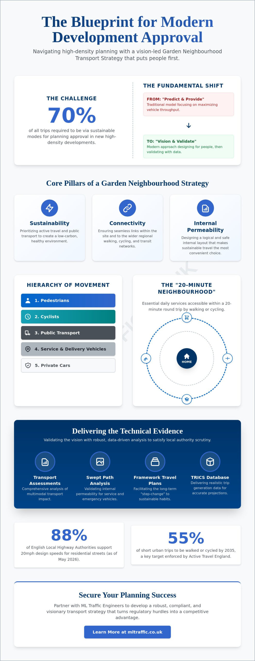
Achieving the “Step-Change”: Travel Plans and Car-Free Design
Success in a garden neighbourhood transport strategy and placemaking framework requires moving beyond physical infrastructure to influence long-term resident behaviour. It’s not enough to build cycle paths; you must ensure people use them. This “step-change” involves a transition from car ownership to a “Mobility as a Service” (MaaS) model. By integrating car clubs and shared transport options from day one, you reduce the perceived need for private vehicles and lower the overall trip generation of the site.
Large-scale garden communities require a Framework Travel Plan to manage this transition effectively. This document serves as a high-level strategy that coordinates individual travel plans across various phases of the development. We recommend moving parking from on-plot locations to peripheral parking hubs. This strategy removes cars from the immediate public realm, which frees up space for higher-quality social areas and creates safer environments for children. When residents park on the edge of the neighbourhood, the “last mile” of their journey becomes a walk through a landscaped environment, naturally reinforcing the hierarchy of movement.
Strategic parking management is the technical key to unlocking car-free zones. By centralising vehicle storage, you can maintain the high-density requirements of garden communities without sacrificing green space. This approach requires careful coordination with local authorities to ensure that off-site parking doesn’t negatively impact existing residents. If you need a partner to develop these complex strategies, our Travel Plan Consultants provide the technical expertise required to secure local authority buy-in and satisfy Section 106 requirements.
Developing an Actionable Travel Plan
An effective plan must include SMART targets for modal shift over a 5 to 10 year period. These targets should be measurable and realistic, based on the specific demographics and location of your development. A dedicated Travel Plan Coordinator usually manages this process, acting as a liaison between residents and transport providers to ensure the community hits its sustainability goals. For a deeper look at the regulatory requirements for these documents, consult our London Travel Plans: The Essential Guide.
Electric Vehicle (EV) Infrastructure Integration
Future-proofing is a non-negotiable requirement for modern garden communities. With the UK target for 100% EV adoption by 2035, your strategy must account for comprehensive charging networks from the outset. This involves balancing high charging demand with existing grid capacity, which often requires innovative energy management systems. We help developers design efficient layouts for both on-street and off-street charging points. This ensures your neighbourhood remains functional and compliant with evolving legislative standards without compromising the aesthetic quality of the streetscape.
Partnering with ML Traffic Engineers UK for Planning Success
Securing planning approval for modern developments requires a partner who understands that a garden neighbourhood transport strategy and placemaking framework is a technical necessity; it’s not just a design preference. ML Traffic Engineers UK provides the specialized industry expertise needed to navigate the increasingly strict regulatory environments of England’s local authorities. Our team balances technical authority with a client-focused approach, aiming to reduce the logistical and regulatory pressures on your development team. By delivering precise, data-driven reports, we ensure your vision for a sustainable community meets every statutory benchmark.
Our all-encompassing service model manages the full project lifecycle from inception to completion. We begin with comprehensive Traffic Surveys and Parking Surveys to establish an accurate baseline of existing conditions. This data informs the development of robust Transport Assessments and Travel Plans tailored to the specific requirements of your site. ML Traffic Engineers UK understands these intricate regional regulations so you don’t have to, positioning your project as a model of professional integrity and public safety.
Why Technical Precision Matters in 2026
Local councils have significantly increased their scrutiny of planning applications following the updated Local Transport Plan guidance in April 2026. Inaccurate data or poorly modeled vehicle movements can lead to costly design errors and lengthy delays in the planning queue. ML Traffic Engineers UK prevents these setbacks by utilizing advanced digital tools for Swept Path Analysis. This ensures that your pedestrian-friendly layouts remain functionally safe for essential services. Our commitment to precision reflects the high-stakes nature of the industry and provides the reassurance planning officers need to grant approval.
Get Started with Your Transport Strategy
Early engagement in the planning lifecycle is the most effective way to avoid regulatory friction. We recommend a comprehensive review of your car park and access layout during the initial design phase to identify potential issues before they become permanent obstacles. Whether you’re working on a large-scale community or a smaller infill project, we provide the technical evidence required to justify your design choices. You can contact ML Traffic Engineers UK for a professional Transport Statement or Assessment to ensure your garden neighbourhood transport strategy and placemaking objectives are both visionary and technically sound.
Securing Future-Proof Planning Approval
Mastering the balance between high-density placemaking and strict sustainable travel targets ensures your project withstands intense local authority scrutiny. You’ve seen how technical precision in Swept Path Analysis and vision-led transport assessments creates a functional foundation for modern, car-free environments. By prioritising the hierarchy of movement from the inception of your design, you turn complex regulatory hurdles into a distinct competitive advantage for your development. It’s the technical evidence that ultimately bridges the gap between a visionary masterplan and a successful planning outcome.
A robust garden neighbourhood transport strategy and placemaking approach requires an all-encompassing partner who understands intricate UK statutory requirements. Founded in 2014, ML Traffic Engineers UK brings over a decade of planning success and reliability to your project team. We are proven specialists in Swept Path Analysis and Transport Statements, providing the expert knowledge necessary to navigate the rigorous 2026 planning landscape. Secure your development’s future with a professional Transport Strategy from ML Traffic Engineers UK. Our team is ready to help you transform your architectural vision into a technically sound and approved reality.
Frequently Asked Questions
What is the difference between a Transport Strategy and a Transport Assessment?
A transport strategy provides the long-term vision and policy framework for movement across a development area, while a Transport Assessment is the site-specific technical document that evaluates the impact of a project on the local highway network. The strategy sets the high-level goals for sustainable travel and connectivity. In contrast, the assessment uses empirical data to prove those goals are both safe and achievable for a specific planning application.
Is a 70% sustainable travel target mandatory for all garden communities?
While not a statutory national requirement for every single development, many local authorities mandate a 70% sustainable travel target to grant official “Garden” status to a project. This high benchmark reflects the government’s CWIS3 goals for the 2025 to 2030 period. Meeting this target usually requires a comprehensive garden neighbourhood transport strategy and placemaking framework that prioritizes walking, cycling, and public transport over private vehicle use.
How does Swept Path Analysis help with placemaking?
Swept Path Analysis allows designers to create narrower, more social streetscapes by digitally proving that essential service and emergency vehicles can still navigate the layout safely. This technical validation gives planning officers the confidence to approve people-centric designs that deviate from traditional, car-heavy highway standards. It ensures that your aesthetic and social goals don’t compromise the functional safety or accessibility of the neighbourhood for refuse trucks or fire tenders.
Can I still include car parking in a garden neighbourhood transport strategy?
You can still include car parking, but modern strategies often shift away from traditional on-plot parking toward peripheral parking hubs or discreetly integrated spaces. This approach removes vehicles from the immediate public realm to enhance the social quality of the streets for residents. Strategic parking management, supported by detailed Parking Surveys, allows you to maintain necessary vehicle access while adhering to the core principles of garden community design.
What is a “20-minute neighbourhood” in the context of UK planning?
The 20-minute neighbourhood is a planning metric used in 2026 to ensure residents can access all daily essential services within a 20-minute round trip via active travel. This concept relies on high-density, mixed-use layouts to reduce car dependency for short journeys. It’s a key component of the vision-led approach now favored in Local Transport Plan guidance to create self-sustaining, healthier communities that reduce pressure on the wider road network.
How do I prove my development meets Healthy Streets principles?
You prove compliance by conducting a qualitative audit against the ten Healthy Streets indicators, which include factors like shade, air quality, and places to stop. This evidence is typically integrated into your Transport Assessment to demonstrate that the development supports public health and wellbeing. Providing specific data on noise levels and pedestrian comfort levels helps convince local authorities that your street design prioritizes the human experience over vehicle throughput.
What role does the TRICS database play in garden neighbourhood planning?
The TRICS database allows us to project realistic trip generation rates by comparing your project to similar, existing sustainable developments across the UK. Using accurate TRICS data prevents the over-estimation of vehicle traffic that often occurs with standard suburban models. This precision is vital for a garden neighbourhood transport strategy and placemaking plan, as it justifies reduced road capacity and supports your sustainability claims with empirical, site-specific evidence.
Will a Travel Plan actually help me get planning permission?
A Travel Plan is a statutory requirement for most significant developments and acts as a primary tool for mitigating the transport impacts of a project. It provides a structured roadmap for achieving behavioural change through measurable targets and long-term monitoring. By demonstrating a clear commitment to reducing car dependency, a robust Travel Plan reduces regulatory friction and significantly increases your chances of securing planning permission from the local authority.

Disclaimer
The content on mltraffic.co.uk, including all technical articles, guides, and resources, is provided for general informational and educational purposes only. It is not intended to constitute professional advice in traffic engineering, transportation planning, development approvals, or any other technical or legal field.
While ML Traffic Engineers makes every reasonable effort to ensure the accuracy, completeness, and timeliness of the information published, we do not provide any warranties or representations (express or implied) regarding its reliability, suitability, or availability for any particular purpose. Any reliance you place on the content is strictly at your own risk.
In no event shall ML Traffic Engineers, its directors, employees, authors, or affiliates be liable for any direct, indirect, incidental, special, consequential, or punitive damages (including, without limitation, loss of profits, data, or business opportunities) arising out of or in connection with the use of, or inability to use, any information provided on this website.
The articles and guides on this site are not a substitute for engaging a qualified, professional traffic engineer to assess your specific project requirements. For tailored advice, compliance assessments, or traffic engineering services, please contact a competent professional.
This disclaimer may be updated from time to time without notice. By accessing or using this website, you agree to be bound by the most current version of this disclaimer.