A car-free fast food restaurant in Central London can look deceptively simple from a transport point of view. No customer parking, strong public transport links, high footfall, job done? Not quite. In 2026, planning officers, TfL and central borough highways teams are focusing far less on whether customers arrive by car and far more on the total movement picture a use creates. That means pedestrian surges outside the frontage, delivery riders waiting on footways, short-stay pick-up activity, servicing windows, refuse collections, and the knock-on effect on crossings, bus stops and cycle lanes.
For applicants, that shift matters. A Car-Free Fast Food Restaurant in Central London Transport Assessment now needs to show not only policy compliance, but operational realism. Officers will expect evidence that the proposal aligns with the London Plan, Vision Zero and Healthy Streets, and that it won’t create severe transport impacts in a location already under pressure.
We’ve found that the strongest assessments don’t rely on generic statements about “excellent accessibility”. They quantify catchments, observe street conditions at the right times, separate customer, staff and rider trips, and explain exactly how kerbside activity will be managed. For architects, planners, lawyers, developers and local authorities, that level of detail often makes the difference between a smooth validation process and a round of avoidable objections. The sections below set out what a robust assessment should cover, and where fast food applications in Central London most often come unstuck.
Key Takeaways
- A car-free fast food restaurant in Central London requires a detailed Transport Assessment focusing on pedestrian surges, delivery rider activity, kerbside management, and local safety, beyond just parking absence.
- Transport Assessments must align with London Plan, Vision Zero, and Healthy Streets policies, demonstrating safe, efficient operation within the constrained urban street environment.
- Quantifying customer, staff, and delivery rider trips separately and assessing peak trading periods are crucial to understanding true transport impacts.
- Robust assessments audit actual walking routes, crossing convenience, cycling access, and kerbside usage to identify local operational challenges and potential conflicts.
- Delivery rider management and servicing strategies need clear, evidence-based plans covering waiting areas, loading times, and refuse collection to avoid street obstructions.
- Specific mitigation measures like cycle parking, kerbside management, and travel planning linked directly to identified risks are essential for smooth planning approval.
Why A Car-Free Fast Food Use Still Needs A Robust Transport Assessment
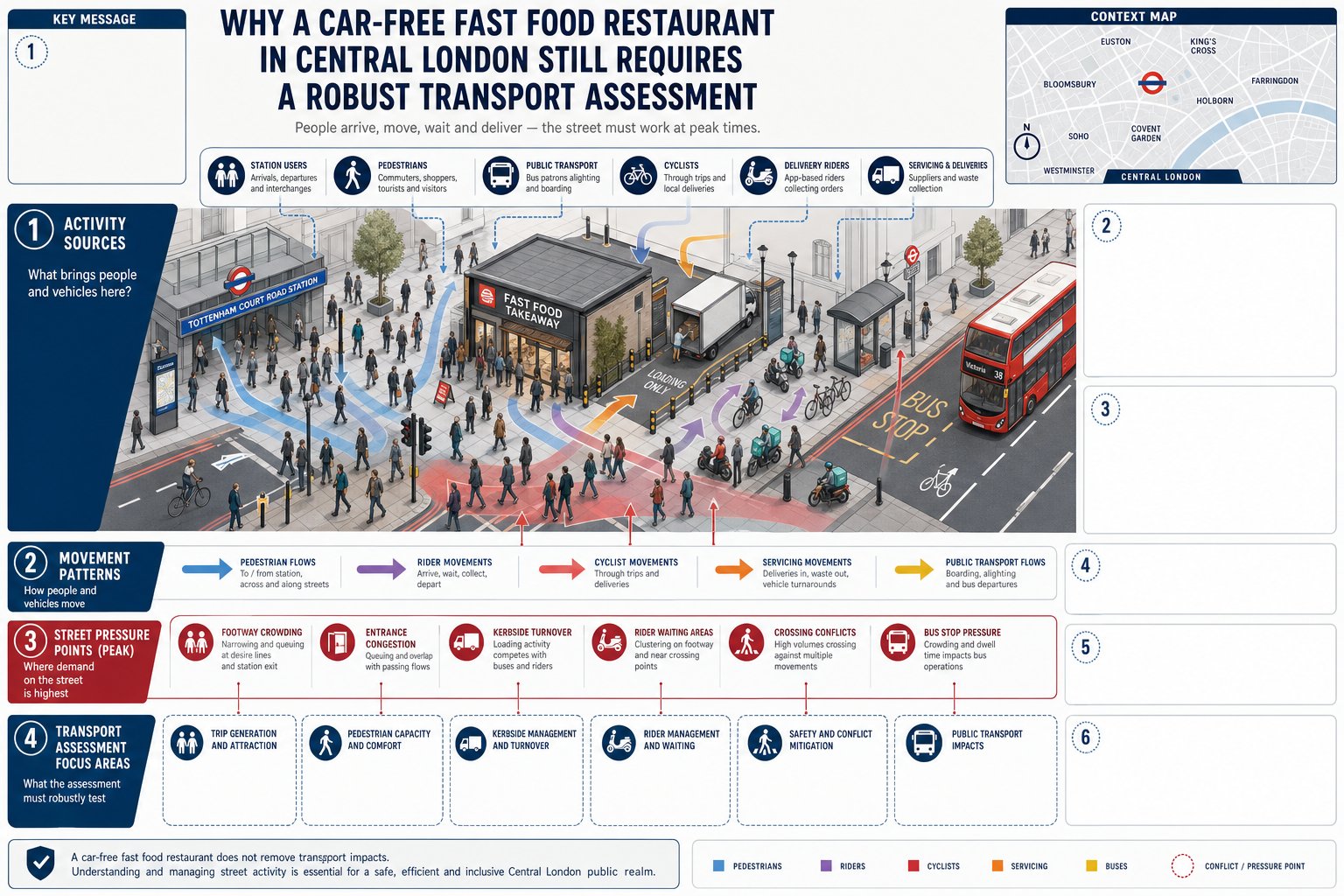
The phrase “car-free” sometimes gives applicants a false sense of security. In policy terms, car-free does not mean impact-free. A fast food restaurant in Central London can generate very high person-trip volumes and, more importantly, concentrated activity in constrained public realm conditions. Planning officers are hence looking at movements, conflict and street operation, not simply whether a site includes parking spaces.
A robust Transport Assessment is needed because the test remains whether the development would result in unacceptable impacts on highway safety, or severe residual cumulative impacts on the road network. In central areas, those impacts are often pedestrian and kerbside-led rather than car-led. A unit near a station entrance, late-night economy cluster or busy bus corridor may intensify footway crowding and rider turnover even without a single customer car space.
That is why a good assessment must move beyond template wording. It should explain the land use properly, identify peak trading periods, assess likely delivery-platform demand and show how servicing will be controlled. In practice, the standard expected is consistent with wider transport assessment for work across London: evidence-led, local, and proportionate to risk.
For fast food uses, the real planning question is usually this: can the site absorb the activity safely and efficiently within the surrounding street network? If we cannot answer that clearly, officers will ask for more.
How Central London Policy Shapes Trip Generation, Mode Choice, And Servicing
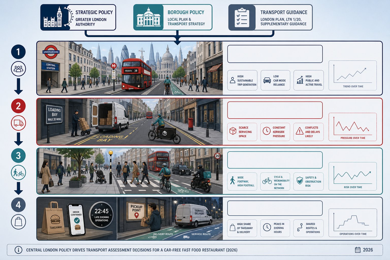
Central London policy is strongly supportive of car-free development, but that support comes with obligations. The London Plan, borough plans and TfL guidance all point in the same direction: maximise walking, cycling and public transport use, reduce road danger, and manage deliveries and servicing tightly. So when we prepare a TA for a car-free fast food restaurant, we are not arguing for car restraint as though it were a special benefit. It is usually the policy baseline.
What officers want to understand is whether the proposal behaves in a way that fits that baseline. Trip generation must reflect a genuinely central location, with high walk-up demand, low car ownership, and strong public transport accessibility. But servicing must also reflect the reality of dense urban streets where loading space is scarce and kerbside pressure is constant. In other words, high sustainable mode share does not remove the need for management: it increases it.
Healthy Streets is especially influential here. A restaurant may support local vitality, but if riders spill into the carriageway, footways become obstructed, or crossings become harder to use, the scheme will conflict with the outcomes policy is trying to secure. That wider policy framing is a recurring part of London Development Transport Advice: not just for major schemes, but for smaller town-centre uses with disproportionate street-level effects.
In 2026, officers also expect applicants to be candid about the operational model. Delivery-led business, extended hours, app-based collections and shared servicing all need to be stated upfront, because policy compliance rests on how the use actually functions day to day.
Defining The Site Context And Catchment Area
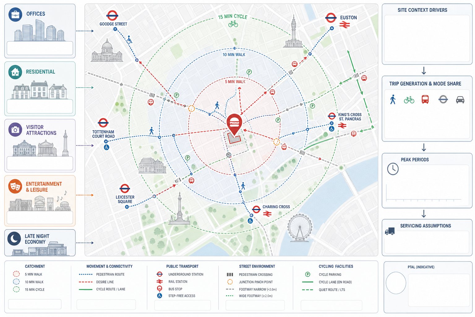
A convincing TA starts by defining the site in its true urban context, not in abstract map terms. For a Central London fast food unit, that means looking closely at the surrounding land-use mix, density, nearby offices, visitor destinations, residential streets, transport hubs and late-night economy patterns. The same floorspace can behave very differently beside a major Underground station than it does on a quieter secondary street.
We usually need to explain the likely customer catchment in practical terms. In Central London, typical walk catchments often sit comfortably within 400 to 800 metres, though footfall-generating hubs can draw customers from shorter, more intense corridors. Cycle catchments of roughly 2 to 3 kilometres may also be realistic where routes are direct and perceived safety is good. Staff catchments can be wider, particularly where shift work aligns with night bus and rail services.
Catchment definition also helps the trip-generation story make sense. If the proposal sits in a mixed commercial area with dense lunchtime demand, the assessment should say so. If evening trade is likely to come from nearby entertainment uses, that matters too. This kind of context-setting is often strongest when coordinated with a wider mixed use masterplan understanding of how surrounding uses already shape movement.
Done well, this section gives officers confidence that later assumptions on mode share, peak periods and servicing are rooted in place, not generic benchmarks.
PTAL, Walking Routes, Cycling Access, And Public Transport Connectivity
PTAL remains an important shorthand for public transport accessibility, and in Central London it will often be high or very high. But PTAL on its own is not enough. Officers increasingly expect us to explain what that accessibility means on the ground: which bus routes serve the frontage, where the nearest Underground and rail stations are, whether step-free access is available, and how service frequency supports staff and customer travel across the opening day.
Walking analysis should be equally tangible. We should audit route widths, surfacing, lighting, natural surveillance, crossing convenience and likely desire lines, especially between stations, bus stops and the restaurant entrance. Cycling access deserves the same attention: nearby cycle lanes, low-traffic routes, junction stress points, available cycle parking and potential conflict with riders stopping informally outside.
Where this work is done carefully, it supports the case that people will choose active and sustainable modes. And where local conditions are less straightforward, a narrow footway, hostile junction, awkward crossing sequence, it flags issues early enough for mitigation. That level of practical appraisal is exactly what a Traffic Engineer In London: planning context demands.
Assessing Existing Highway Conditions Around The Site
Existing conditions work is where many fast food assessments either become credible or start to unravel. A desk-based description of the surrounding road network is not enough. We need to understand how the street currently operates at the times the proposed use will add pressure, often lunchtime, early evening and late evening, with different issues in each period.
That means recording carriageway hierarchy, junction forms, waiting and loading restrictions, bus stop clearways, cycle infrastructure, taxi activity, and the practical use of nearby kerbside space. A loading bay that exists in theory may already be fully occupied in practice. Likewise, a side street that looks suitable for servicing on plan may function as an informal pick-up space after dark.
Officers are alert to these differences because they see them repeatedly in enforcement complaints and local objections. If a TA glosses over actual kerbside behaviour, confidence drops quickly. We often advise site observations across multiple days, not just one short weekday survey, particularly where the unit is expected to trade into the evening or rely heavily on app-based delivery.
There is also a cumulative angle. In Central London, surrounding uses rarely operate in isolation. Nearby cafés, convenience stores, hotels and residential servicing can all be competing for the same kerb at the same hour. Occasionally, the wider network context overlaps with environmental impact assessment concerns where traffic, air quality or public realm pressures interact, though a standalone fast food unit will often sit below EIA thresholds.
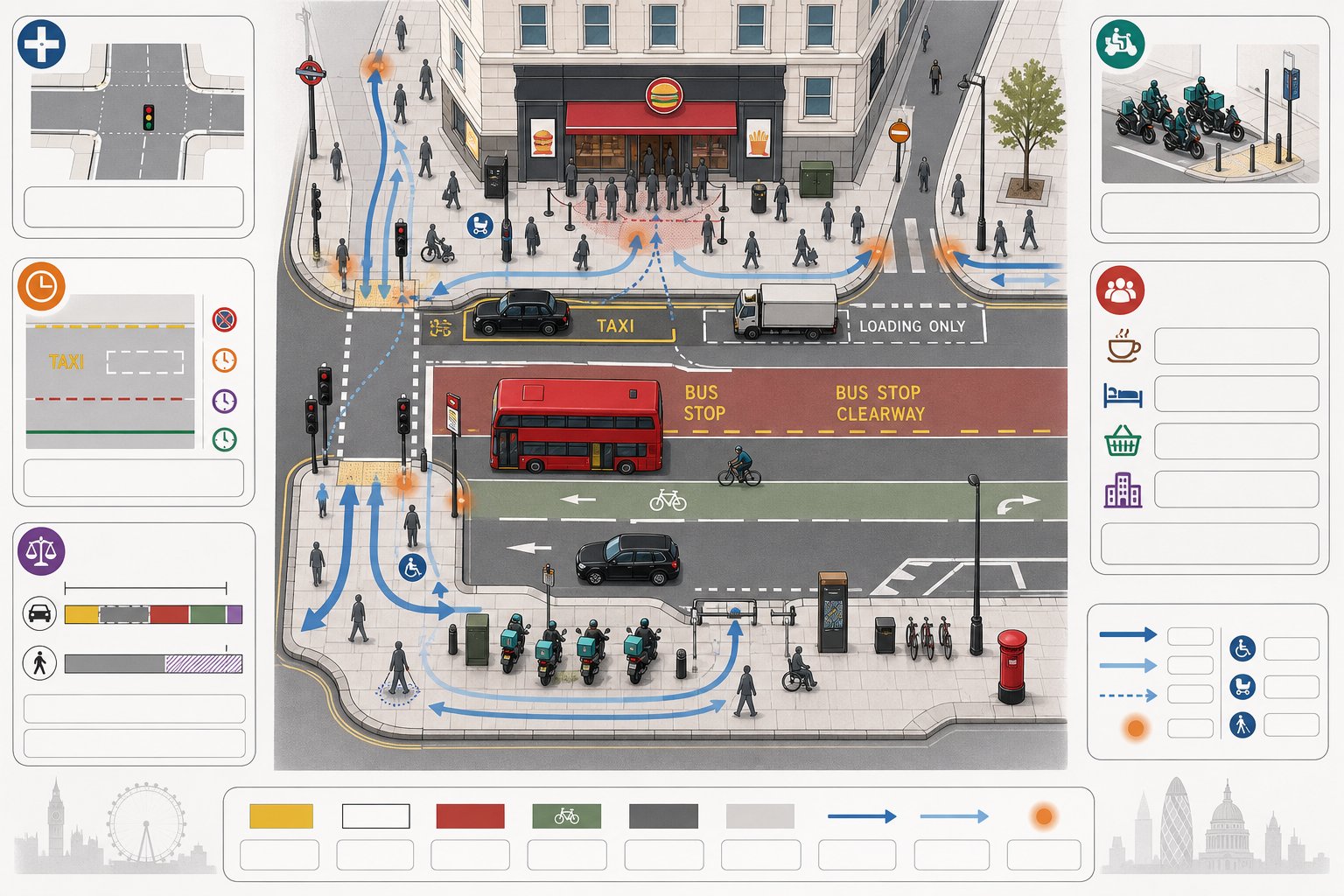
Pedestrian Movement, Crossing Demand, And Footway Capacity
For many car-free fast food proposals, pedestrian conditions are the main issue. The frontage may attract queueing, waiting, informal social gathering and rider congregation all at once. Add existing commuter flows or station dispersal, and a modest retail unit can create a surprisingly messy pinch point.
A proper assessment should identify current pedestrian volumes, crossing desire lines and any existing congestion on footways or at signalised crossings. Where footways are narrow, effective width matters more than nominal width: guardrailing, utility boxes, café furniture, signs and waiting riders all reduce usable space. We also need to think about inclusive movement. Can wheelchair users, pushchairs and visually impaired pedestrians pass comfortably at peak times?
If a crossing nearby already experiences heavy demand, new trade may increase risky informal crossings. That is exactly the kind of Healthy Streets and Vision Zero concern officers take seriously. Sometimes the issue is not raw volume but behaviour, people clustering by the entrance, then spilling into the carriageway while waiting for collections. Good survey notes, photographs and time-specific observations are often as useful as counts here.
Trip Generation For A Fast Food Restaurant Without Customer Parking
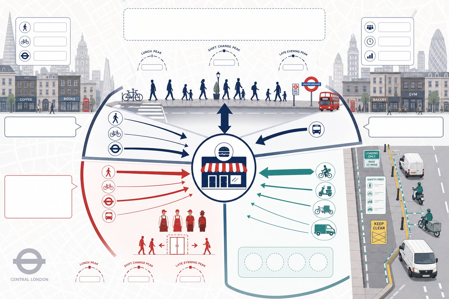
Trip generation for a car-free fast food restaurant needs a more nuanced approach than simply saying “there will be no parking, so car trips will be negligible”. That may be broadly true for customer cars in Central London, but it tells only part of the story. We need to estimate total person trips and then break them down by purpose and mode.
Comparable London data can help, but raw benchmarks should be adjusted carefully for central-area conditions, walk-up trade, opening hours, floor area, brand recognition and whether the business model is dine-in, takeaway, delivery-led or some mix of the three. A station-adjacent grab-and-go unit may peak sharply at lunch. A late-opening takeaway near entertainment uses may peak much later. Generic suburban rates can mislead badly.
The most useful structure is usually to separate:
- customer trips by walking, cycling, public transport and negligible car use:
- staff trips, including arrival and departure at shift-change periods:
- delivery and collection trips, which may dominate motorised activity.
That separation matters because the transport impacts differ. Customer walk trips affect frontage crowding. Staff trips may be dispersed but can create early or late public transport dependence. Rider trips create kerbside and safety issues. Where the site sits within a broader urban area containing housing as well as commercial uses, lessons from a Residential Development Transport Assessment: can also be relevant, especially around sensitive evening impacts and neighbour amenity.
In short, no parking does not remove the need for numbers. It just changes which numbers matter most.
Delivery Riders, Collection Activity, And Kerbside Pick-Up Demand
This is often the make-or-break section. For many modern fast food operators in Central London, delivery-platform riders and app-based collection activity create the main transport impact. If the TA treats this as a footnote, planning officers will notice immediately.
We need to quantify likely rider arrivals, waiting demand, dwell times and turnover patterns. Third-party platform collections, branded fleet operations, customer click-and-collect and taxi or private hire pick-up can all contribute to short-duration but high-frequency kerbside activity. The effect is often less about traffic volume and more about where vehicles stop, how long they wait, and whether the street can absorb that behaviour without obstruction.
A robust assessment should map likely pick-up points and explain why those points are realistic. If there is no lawful or practical stopping opportunity close to the frontage, the report must confront the risk of illegal stopping, bus stop interference, loading bay misuse or cycle lane blockage. We cannot simply assume perfect compliance because an operator intends to issue instructions through an app.
Observed comparator evidence can be very useful here, especially for similar Central London sites with a strong delivery share. In some cases, rider management needs to include designated waiting arrangements, geofenced instructions, collection shelving that reduces dwell time, and active staff supervision during peaks. Those details are not operational trivia: they are transport evidence.
It is also worth distinguishing between rider movement and rider waiting. A site may generate manageable approach trips but unacceptable footway occupation if several riders arrive early and gather outside. Officers increasingly ask about both.
Servicing, Refuse Collection, And Loading Arrangements
Fast food units may be small in floorspace, but they can be intensive in servicing terms. Food deliveries, packaging supplies, cleaning materials, gas or maintenance visits, and frequent refuse collection all need a clear strategy. In Central London, where kerbside space is tightly managed, this is one of the most scrutinised parts of the TA.
A sound servicing strategy should identify vehicle types, frequency, time windows, stopping locations and routeing. If on-street loading is proposed, the report should confirm restrictions and show that deliveries can occur without conflict with bus operations, crossing points or mandatory cycle lanes. If off-street servicing is available through a rear service yard or shared bay, officers will want to know how it is accessed, managed and kept available.
Swept path evidence is often needed where manoeuvring is constrained, especially in mews streets or tightly controlled service areas. Refuse arrangements also need more than a passing mention. Storage capacity, collection frequency, presentation points and drag distances should all make operational sense. Otherwise a tidy servicing plan on paper can turn into bins and bags appearing on the footway at the busiest time of day.
This is a good example of where concise technical reporting pays off. Well-structured London Development Transport evidence tends to prevent exactly the kind of follow-up questions that slow validation and invite highways objections.
Road Safety, Conflict Risks, And Local Operational Impacts
Road safety assessment should be proportionate, but it must be real. Vision Zero has changed the tone of planning discussions in London: officers are not only asking whether collision numbers are high, but whether a proposal could worsen known conflict patterns, particularly for pedestrians, cyclists and motorcyclists.
We should hence review recent collision records in the vicinity and interpret them intelligently. A cluster involving turning vehicles near the site entrance, cycle collisions by a loading bay, or pedestrian incidents close to a crossing can all be relevant. The aim is not to overstate risk, but to show that the proposal has been tested against local safety conditions.
For fast food uses, likely conflict points usually include:
- the restaurant entrance and immediate frontage:
- rider waiting areas and informal stopping points:
- loading locations:
- nearby junctions and crossing facilities:
- late-night routes used by staff and riders.
Night-time conditions matter more than some applicants assume. Lower traffic flow does not automatically mean lower risk, especially where visibility, personal security, intoxicated pedestrians or informal stopping behaviour become factors. A TA should also consider whether the operation changes the character of the frontage after dark.
Where safety concerns are more complex, it can help to frame the analysis with the same disciplined approach used in wider environmental impact assessment transport: work: identify receptors, assess likely effects, and explain mitigation clearly. That makes the argument easier for officers to follow, and harder to dismiss.
Mitigation Measures And Travel Planning To Support A Planning Application
Good mitigation is specific. Vague promises to “encourage sustainable travel” or “manage deliveries responsibly” do very little in a Central London planning application. Officers want measures that match the risks identified in the TA and can realistically be secured by condition, obligation or operational management.
Typical measures for a car-free fast food restaurant include staff and customer cycle parking, widened clear space outside the entrance, adjusted door layout to reduce spill-out, better signage to direct riders, and agreed loading arrangements with time controls. In some cases, a contribution towards a crossing improvement or local footway enhancement may be justified if frontage pressure is material.
Travel planning still has a role, especially for staff. A concise Travel Plan can set mode share expectations, cycle parking provision, staff induction information, public transport season-ticket promotion where appropriate, and reporting arrangements. But for this land use, delivery and servicing management is usually the stronger lever. A Delivery and Servicing Plan should define vehicle types, booking procedures, prohibited waiting locations, rider instructions, escalation steps and monitoring.
The most persuasive mitigation packages are operationally honest. If the business expects heavy app-based trade, the plan should say exactly how rider demand will be controlled. If a shared loading bay is crucial, management responsibility should be explicit. That is the standard a capable Traffic Engineer In London application now needs to meet.
Common Evidence Gaps That Delay Validation Or Trigger Objections
Most delays on these applications are avoidable. The recurring problem is not that policy is unclear: it is that evidence is incomplete, too generic or obviously disconnected from how the use will operate.
The biggest gap is usually unquantified delivery rider and kerbside activity. Applicants may describe delivery demand qualitatively, then offer no estimates, no comparator evidence and no mapped stopping strategy. That leaves officers to imagine the worst, and they often do.
Another common weakness is limited accessibility analysis. A high-PTAL location is presented as self-evidently acceptable, but the report says little about actual walking routes, crossing conditions, cycle access or frontage constraints. That misses the point. Central London policy supports sustainable mode share, yes, but it also expects developments to work well within the street environment.
We also regularly see:
- no collision review or only a superficial road safety note:
- servicing strategies without restrictions checks or swept paths:
- refusal to distinguish customer, staff and rider trip types:
- no explanation of peak trading periods and late-night conditions:
- weak references to London Plan, Healthy Streets and Vision Zero without analysis.
In our experience, concise evidence is usually better than bulky evidence. Officers do not need a report padded with generic policy extracts: they need a document that answers the operational questions clearly. That is true across all transport assessment for developments: work, but especially for smaller urban schemes where local effects are highly visible.
Conclusion
A car-free fast food restaurant in Central London is not judged simply by the absence of parking. In 2026, the planning focus is on whether the use can operate cleanly within a dense, highly constrained street environment. That means the Transport Assessment has to deal with the real sources of impact: pedestrian intensity, rider activity, kerbside pressure, servicing and safety.
When we prepare this type of assessment well, the pattern is consistent. We define the catchment properly, test the street conditions at the right times, separate customer, staff and rider movements, and provide a practical servicing and mitigation strategy that reflects how the operator will actually trade. When those pieces are missing, objections usually follow.
For architects, planners, developers, lawyers and councils, the key takeaway is straightforward: a robust Car-Free Fast Food Restaurant in Central London Transport Assessment should be evidence-led, site-specific and operationally honest. That is what planning officers expect now, and it is what gives an application the best chance of moving forward without avoidable delay.
Frequently Asked Questions about Car-Free Fast Food Restaurant Transport Assessments in Central London
Why is a Transport Assessment necessary for a car-free fast food restaurant in Central London?
A car-free fast food restaurant still generates significant pedestrian, delivery rider, and servicing movements that impact the local street environment. A Transport Assessment ensures these impacts comply with the London Plan, Vision Zero, and Healthy Streets policies, avoiding severe transport and safety problems.
How does central London policy influence trip generation and servicing for car-free fast food restaurants?
Central London policies strongly support car-free developments but expect high walking, cycling, and public transport use along with robust servicing management. Trip generation must reflect dense urban catchments and mode share, while servicing plans must address limited kerbside space and delivery impacts aligned with transport guidance.
What should a robust Transport Assessment include for this type of development?
It should define the detailed site context and catchment, analyse public transport accessibility beyond PTAL scores, audit walking and cycling routes, quantify customer, staff, and rider trips separately, and provide practical servicing, refuse collection, and rider management strategies to demonstrate operational realism and safety.
How are delivery riders and kerbside pick-up managed in these assessments?
The assessment must quantify likely delivery rider arrivals, waiting times, and pick-up locations. It should map kerbside demand and risks like illegal stopping or cycle lane obstruction, proposing mitigation such as designated waiting areas, geofencing, and active rider supervision to ensure safe, efficient street operation.
What common evidence gaps delay Transport Assessment approvals for car-free fast food restaurants?
Delays often arise from insufficient quantification of delivery rider and kerbside activity, lack of detailed PTAL and active mode accessibility analysis, missing collision and road safety reviews, inadequate servicing strategies with no swept path evidence, and weak alignment with key London transport policies.
How can mitigation measures improve the Transport Assessment and planning approval prospects?
Specific mitigation like enhanced cycle parking, improved pedestrian crossings, time-controlled loading bays, and comprehensive Delivery and Servicing Plans that manage rider behaviour are crucial. Travel plans encouraging sustainable staff travel combined with operational honesty increase confidence and reduce objections in the planning process.