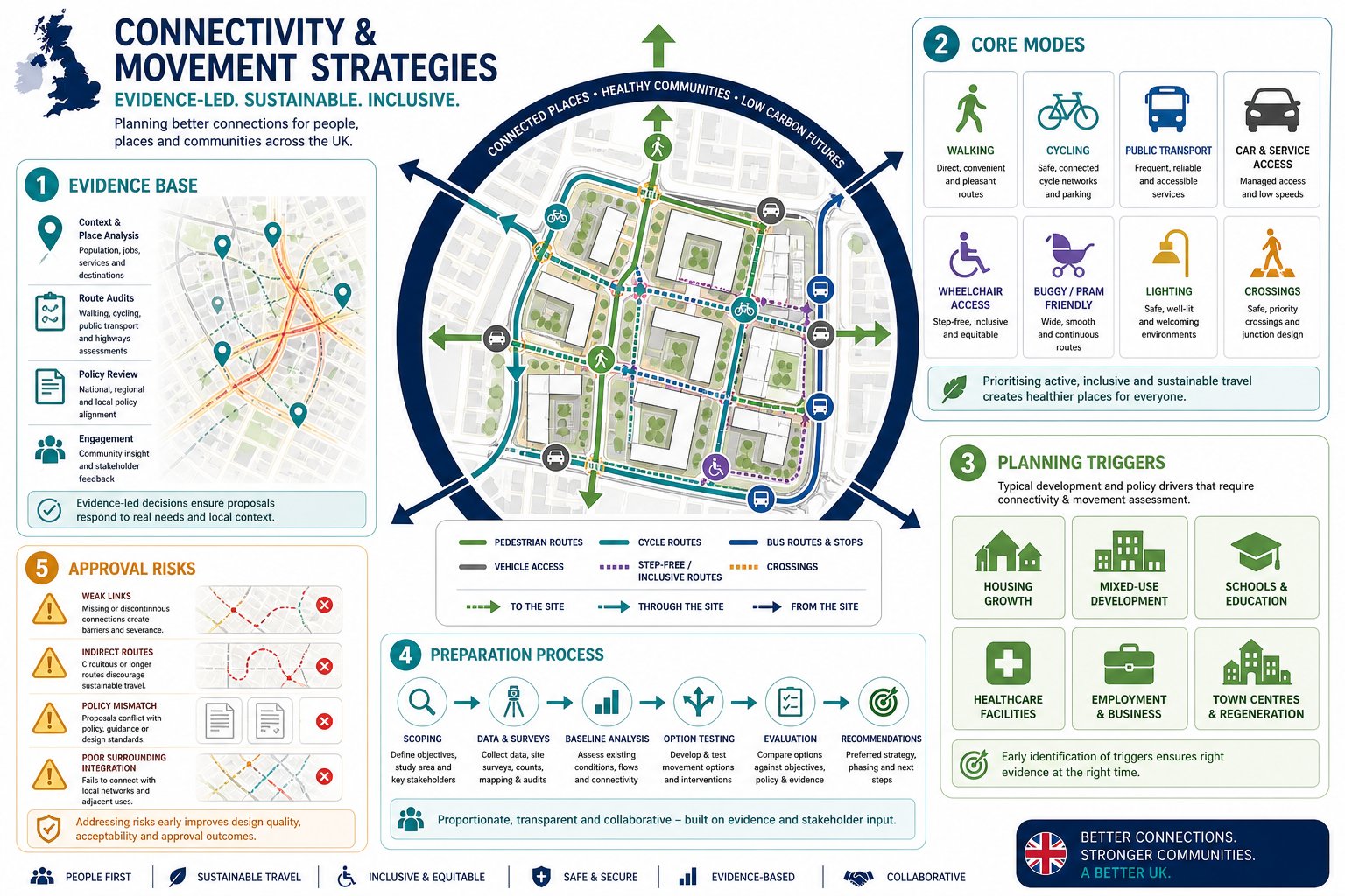
Planning outcomes are rarely decided by traffic numbers alone. Increasingly, local authorities want to see how a scheme will actually work as a place: how people will arrive, move around, cross streets, reach bus stops, cycle safely, and navigate the site if they are pushing a buggy, using a wheelchair, or walking home after dark. That is where connectivity and movement strategies come in.
For architects, planners, developers, surveyors and councils, a strong strategy does more than support an application. It helps shape the layout itself. Done well, it can reduce avoidable objections, improve design quality, and provide a clearer line of sight between policy, access, and deliverability. Done badly, it tends to expose weak links in a scheme very quickly.
In our experience, the best connectivity and movement strategies are practical rather than abstract. They connect site constraints, local policy, transport evidence and place-making principles into one coherent framework. They also speak the language of decision-makers: clarity, proportionate evidence, and a visible commitment to sustainable and inclusive movement.
In this guide, we set out what a connectivity and movement strategy is, when it is needed, what evidence underpins it, how it is prepared, and the issues that most often slow planning approval. The aim is simple: help project teams produce better planning submissions and better places, with less friction in the process.
What A Connectivity And Movement Strategy Is And Why It Matters In Planning
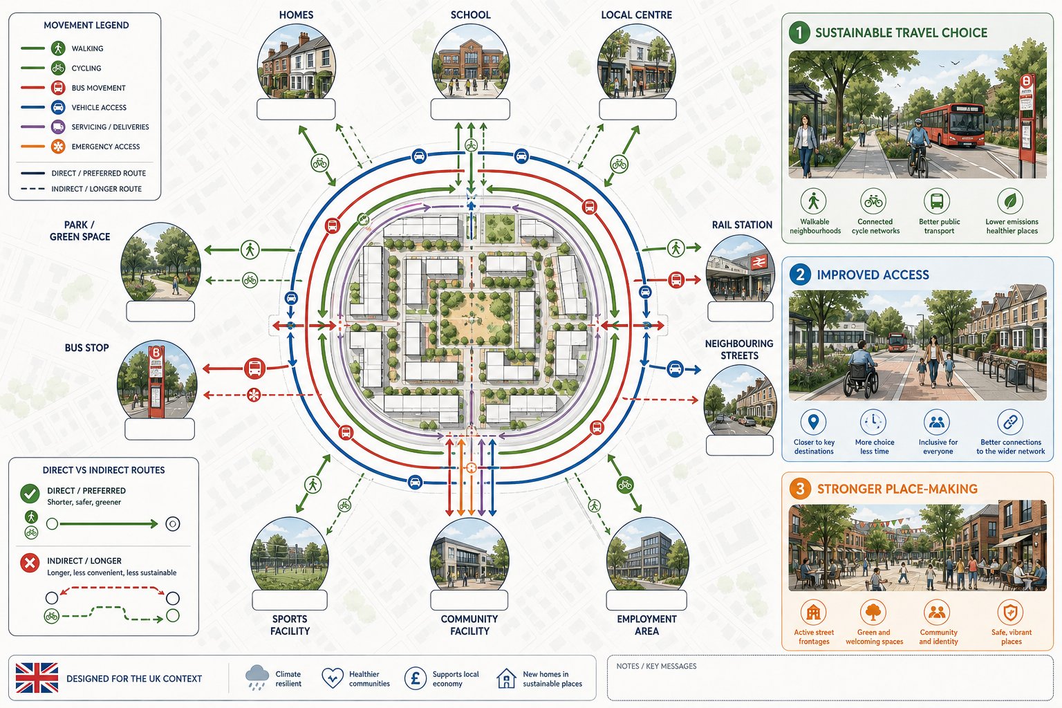
A connectivity and movement strategy is a structured framework showing how people and vehicles will move to, from, and through a development, and how that movement ties into the wider network. In planning terms, it sits at the meeting point of transport, urban design and policy compliance. It is not just a drawing of access points or a broad statement that walking and cycling will be encouraged. It should explain the logic of movement across all modes.
That means looking at walking routes, cycle links, bus access, vehicle access, servicing, emergency access and inclusive movement together rather than in isolation. For many schemes, especially residential, mixed-use, employment and town centre proposals, this joined-up view is central to planning acceptability.
Why does it matter so much? Because movement influences almost everything else. It affects whether a place feels legible, safe and convenient. It affects whether people can realistically choose sustainable modes. It affects street design, parking pressure, junction performance, rights of way, frontage activity and environmental outcomes. And it often determines whether a local authority sees a proposal as policy-aligned or car-led.
A robust strategy also helps avoid a common planning weakness: designing a site internally, then trying to justify its connections afterwards. We see the strongest outcomes when access and movement are considered early, with the layout responding to real desire lines and existing infrastructure rather than forcing awkward, indirect routes.
How It Supports Sustainable Development, Access, And Place-Making
At its best, a connectivity and movement strategy supports sustainable development in a very direct way. It prioritises short, direct and attractive routes for everyday trips, making it easier for residents, employees and visitors to walk, cycle or use public transport instead of defaulting to the car. That shift matters not only for carbon and air quality, but for the day-to-day usability of a scheme.
It also improves access. A well-planned network gives people genuine choices, with routes that are easy to understand, well overlooked, and linked to the destinations that matter: schools, local centres, open space, bus stops, stations and neighbouring streets. The difference between a route that is technically available and one people will actually use is often huge.
Place-making is the other big piece. Streets are not merely corridors for movement: they structure the development. A clear movement framework helps create legible street hierarchy, stronger frontages, better public spaces and more sociable environments. In other words, movement is not separate from design quality. It is one of the main ingredients of it.
From a planning perspective, that alignment is powerful. Local authorities increasingly expect schemes to show that access, movement and place-making have been thought through as one integrated proposition, not as separate consultant workstreams stitched together at the end.
When A Connectivity And Movement Strategy Is Needed For A Planning Application
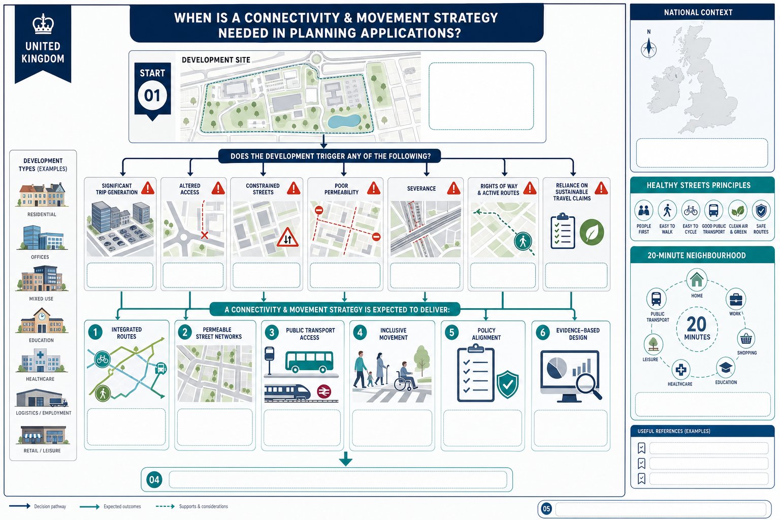
Not every planning application requires a formal standalone connectivity and movement strategy, but many do in practice, either explicitly or because the issues are too important to leave underexplained. Major residential developments, mixed-use schemes, employment sites, education proposals, healthcare uses and town centre regeneration projects are the most common examples.
The need usually becomes clearer where a development is expected to generate significant trips, alter existing access arrangements, interact with constrained streets, or rely on sustainable travel claims to support planning acceptability. In those cases, the strategy often works alongside a Transport Assessment, Design and Access Statement, Travel Plan or framework masterplan.
We also see strategies requested where connectivity is itself a planning issue: perhaps a site sits near a rail station but lacks a direct pedestrian route, or it borders an existing neighbourhood with poor permeability, or there are concerns about severance, rights of way or school travel patterns. In those situations, decision-makers want more than capacity analysis. They want to understand how the development fits into the movement network around it.
For applicants, there is a practical point here. Even where the local authority has not used the exact phrase “connectivity and movement strategy”, the expectation may still exist in local policy, design guidance, pre-application advice or officer feedback. Reading that early can save a lot of redesign later.
Common Development Types, Triggers, And Local Authority Expectations
Typical triggers include major residential applications, urban extensions, estate regeneration, larger commercial schemes, logistics or employment proposals, and mixed-use masterplans where the internal street network needs to be justified. Smaller sites can also trigger the need if they sit in sensitive or highly connected urban locations.
Local authorities generally expect several things. First, clear integration with existing routes, including public rights of way, adopted highways, cycle corridors and nearby public transport. Second, a permeable street network rather than inward-looking cul-de-sacs or token links. Third, visible priority for sustainable and inclusive travel.
They also expect consistency with adopted policy. In England, that often means alignment with the National Planning Policy Framework, local plan transport and design policies, parking standards, active travel guidance and any design code that addresses movement. Some councils are especially focused on healthy streets, 20-minute neighbourhood principles, school access, or reduced car dependence near public transport nodes.
A recurring expectation, and one that is sometimes underestimated, is evidence. Officers and highway authorities want to see that proposed links, crossings, stop locations and access arrangements are grounded in actual site conditions and user needs. Assertions alone rarely carry much weight. The more a strategy can show its workings, the more persuasive it becomes.
Core Principles That Shape An Effective Strategy
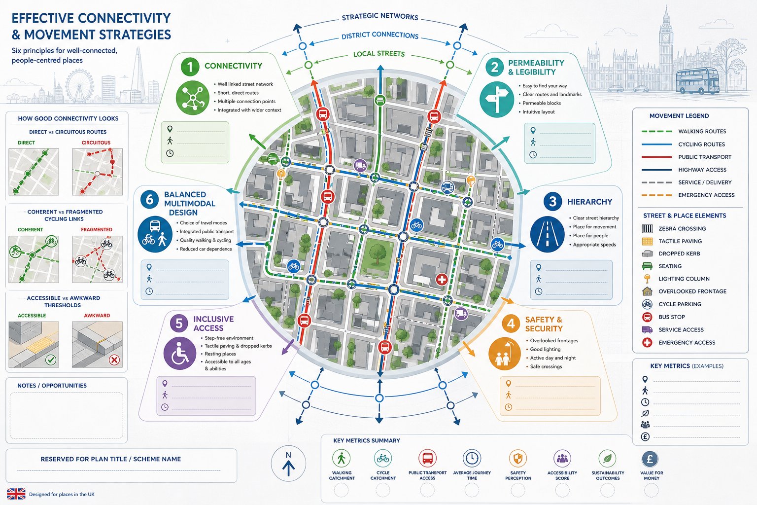
Effective connectivity and movement strategies tend to share a handful of core principles, regardless of site size. The first is connectivity itself: a fine-grain network with enough links and junctions to make movement direct rather than circuitous. If people must take a long detour to reach a bus stop or neighbouring street, many simply will not.
The second is permeability and legibility. Routes should be easy to access and easy to understand. That sounds obvious, yet many plans still produce ambiguous paths, awkward thresholds or networks that only make sense on a consultant drawing. A good strategy should work in real life, for first-time visitors as well as regular users.
The third principle is hierarchy. Not every street or route should do the same job. Primary streets, secondary streets, shared surfaces, cycle routes, pedestrian corridors and service areas each need a clear role. Without hierarchy, layouts become muddled and conflicts between modes tend to increase.
Safety and security are equally important. That includes road safety, but also personal safety: lighting, natural surveillance, overlooked routes and avoiding spaces that feel isolated. Finally, inclusive access must be embedded from the start. It should not be treated as a compliance add-on.
In our work, the most convincing strategies are the ones that balance these principles rather than over-optimising one at the expense of the others. A highly permeable layout that feels unsafe will struggle. So will a technically efficient vehicle layout that undermines walking and place quality.
Walking, Cycling, Public Transport, Highway Access, And Inclusive Movement
Walking should usually be the starting point. Short, direct, well-lit routes with safe crossings and minimal unnecessary level changes are often the clearest test of whether a site is genuinely connected. If the pedestrian route is awkward, the sustainable travel narrative quickly weakens.
Cycling needs coherence, not just isolated bits of infrastructure. An effective strategy shows how cyclists enter the site, move through it, park securely, and connect to wider routes. That may involve segregated facilities, quieter low-speed streets, filtered permeability or improved crossings, depending on context.
Public transport is about more than nearest-stop distance. We need to consider route quality to stops, service frequency, crossing opportunities, passive surveillance, waiting conditions and whether the stop locations align with real desire lines. A bus stop that is technically close but difficult to reach is not much of an asset.
Highway access still matters, of course. Junctions must function safely and efficiently, and servicing, refuse and emergency access must be practical. But highway design should support the place rather than dominate it. Over-engineered geometries can weaken frontage quality, crossing comfort and speed control.
Inclusive movement cuts across every mode. Step-free routes, manageable gradients, tactile paving, dropped kerbs, accessible parking, seating, rest points and clear wayfinding all matter. Good inclusive design is not niche: it makes places easier for everyone to use. And from a planning viewpoint, it is increasingly non-negotiable.
The Evidence Base Behind A Robust Strategy
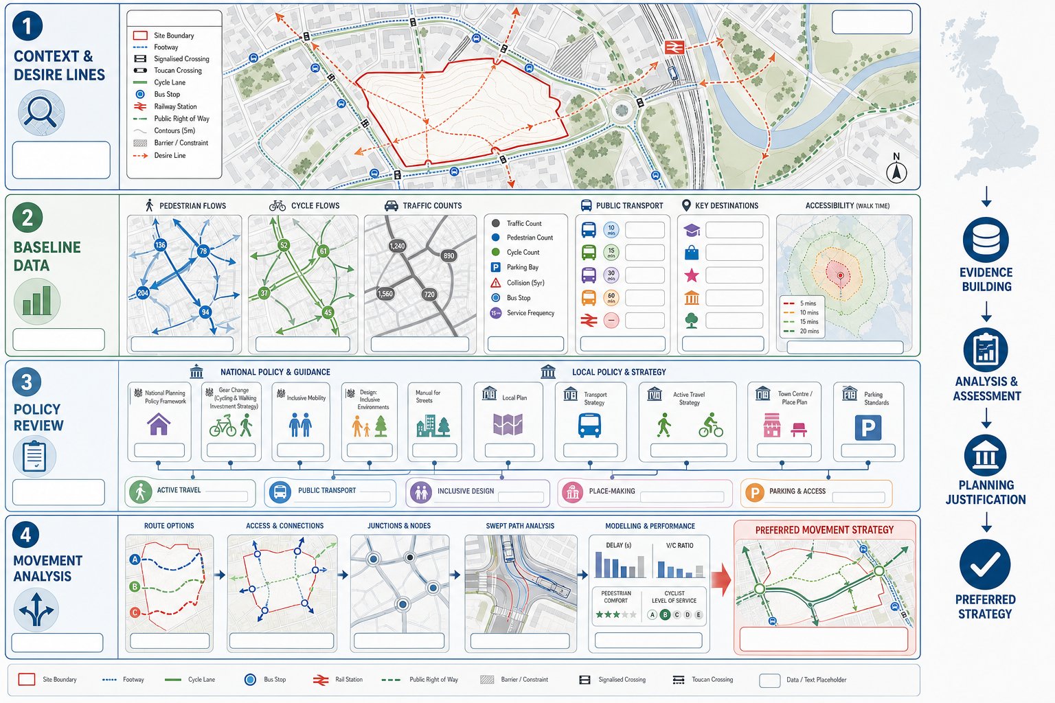
A strong connectivity and movement strategy is only as good as the evidence behind it. Planning officers and highway authorities are used to broad aspirations. What tends to influence them more is a strategy that is clearly rooted in baseline conditions, policy context and proportionate analysis.
The evidence base usually starts with a site and context assessment. We need to understand the surrounding street network, crossing points, cycle provision, bus stops, rail access, rights of way, topography, frontage activity, safety constraints and any severance caused by major roads or barriers. Desire lines are particularly important. People do not move according to neat diagrammatic assumptions: they follow the routes that make sense to them.
From there, baseline data helps test what is really happening. Depending on the scheme, that may include traffic counts, pedestrian and cycle flows, parking stress observations, accessibility mapping, collision data, service frequency data and school or town centre movement patterns. The amount of analysis should be proportionate, but it does need to be credible.
Policy review is the other major pillar. The strategy should show how the scheme responds to national policy, local plan requirements, transport strategies and local design guidance. That policy thread matters because it turns technical analysis into planning justification.
In practice, this is where experience helps. At ML Traffic, for example, our role is often to translate technical evidence into a concise planning narrative that aligns with local authority thresholds and expectations rather than producing data for data’s sake.
Site Assessments, Baseline Data, Policy Review, And Movement Analysis
Site assessments should look beyond the red line boundary. Some of the most important movement issues sit just outside it: missing footways, substandard crossings, barriers to nearby services, bus stop quality, informal desire lines across verges, or a right of way that has been forgotten in early layout work. These edge conditions often become key planning points.
Baseline data should then quantify what the assessment suggests. We may need pedestrian, cycle and traffic surveys, queue observations, speed data, parking accumulation, public transport accessibility measures, or audits of walking and cycling routes. Collision records can reveal safety concerns that are not obvious from a single site visit. GIS and accessibility mapping can be especially useful for showing catchments and comparative route quality.
Policy review should be explicit, not implied. The strategy should identify the transport and movement policies that matter, then show how the scheme responds to them. That may include sustainable transport, active travel, inclusive design, place-making, parking restraint or public realm objectives.
Movement analysis brings those strands together. On some sites, that means straightforward route and access analysis. On others, it may extend to trip generation, junction capacity, swept path work, accessibility modelling or more advanced tools where the highway authority expects them. The point is not to overcomplicate things. It is to provide enough evidence to show that the preferred movement strategy is justified, workable and aligned with planning policy.
How Connectivity And Movement Strategies Are Prepared
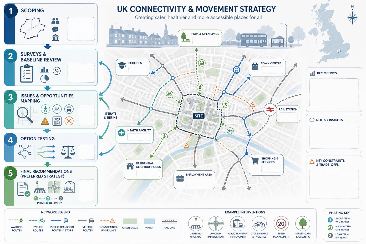
Preparation usually begins long before the final report is written. The best strategies emerge through an iterative process that runs alongside site design, transport assessment and planning input. If movement is left until the layout is largely fixed, options narrow quickly and compromise becomes harder to avoid.
The first step is scoping. We need to define the study area, relevant travel modes, key destinations, planning context and expected evidence requirements. On larger or more sensitive schemes, early discussion with the local planning authority and highway authority can be invaluable. It helps establish what level of detail is expected and where likely concerns sit.
Next comes survey work and baseline review. That can include site visits, route audits, pedestrian and cycle surveys, traffic counts, accessibility mapping, public transport review and policy analysis. The purpose is not just to collect information, but to identify the site’s genuine movement problems and opportunities.
Then we move into strategy development. Different access and network options are tested against practical criteria: safety, convenience, capacity, inclusivity, deliverability and policy fit. Sometimes the answer is obvious. Quite often, though, there is a real trade-off between layout efficiency, frontage quality, parking, servicing or off-site improvements.
The final strategy should set out the preferred approach clearly, using plans and text that are detailed enough for planning but not so technical that the core story gets lost. A good document gives decision-makers confidence that the movement framework is coherent and implementable.
From Scoping And Surveys To Option Testing And Recommendations
Scoping is where we set the rules of the exercise. We identify what the authority is likely to want, what the site conditions suggest, and how the strategy will relate to the Transport Assessment, Travel Plan and design material. Getting this wrong can mean expensive rework later.
Surveys and baseline studies provide the raw material. We typically review walking routes, cycle connectivity, public transport accessibility, highway conditions, collision history, parking, servicing constraints and inclusive access issues. Where needed, we also consider school travel patterns, peak-hour network stress or town centre footfall. Context matters.
Once the baseline is clear, issues and opportunities can be mapped. Maybe there is a missing link to a bus stop, a poor crossing on a distributor road, an internal street that could become a key active travel corridor, or an opportunity to connect into an adjoining site. This is usually the most creative stage, because it is where problems become design options.
Option testing then compares alternatives. We look at how each option performs in terms of route directness, safety, mode share potential, network operation, place quality and deliverability. Some options fail because they are weak technically. Others fail because they are unrealistic to deliver or out of step with policy.
Recommendations should be practical and coordinated. That may include on-site links, crossing improvements, cycle parking, bus stop upgrades, junction changes, phased delivery, parking strategy and supporting Travel Plan measures. The strongest recommendations are specific enough to be useful, but flexible enough to sit comfortably within the planning stage of the project.
Common Issues That Delay Approval And How To Avoid Them
Most delays do not happen because authorities oppose connectivity and movement strategies in principle. They happen because the strategy is incomplete, inconsistent or unconvinving. One of the most common problems is weak baseline evidence. If important desire lines, local rights of way, nearby schools, bus links or safety issues are missing, consultees quickly lose confidence in the wider document.
Another frequent issue is over-reliance on car access. We still see schemes where vehicle access is resolved in detail but walking and cycling links are vague, indirect or clearly secondary. That can be fatal to a planning case, especially where policy places strong emphasis on sustainable transport and healthy place-making.
Poor integration with surrounding networks is another classic stumbling block. A site may function internally, yet fail to connect properly to neighbouring streets, greenways, bus stops or public rights of way. Authorities notice this straight away because it affects not just movement, but how well the development joins the existing place.
Policy mismatch also causes delay. If a strategy does not clearly address adopted design guides, active travel policies, parking standards or accessibility requirements, officers may ask for revisions even where the technical work is otherwise sound. And inclusive access is too often underplayed, treated as a detail for later stages rather than a core design principle.
The fix, in most cases, is straightforward: start earlier, gather better evidence, and make the sustainable and inclusive movement story visible throughout the scheme rather than confining it to a few paragraphs.
In practical terms, we recommend five checks before submission:
- confirm the study area captures all relevant external links and constraints:
- test whether pedestrian and cycle routes are genuinely direct and attractive:
- cross-check the strategy against local policy and design guidance:
- ensure inclusive access is embedded in plans, not left to general statements:
- align the strategy with the Transport Assessment, Travel Plan and site layout.
Those checks sound basic, but they prevent a surprising amount of planning friction. And they help create reports that answer the authority’s likely questions before they are asked.
Conclusion
Connectivity and movement strategies have become a core part of better planning submissions because they deal with a core planning question: will this development function as a connected, accessible and sustainable place? For many schemes in 2026, that question carries as much weight as conventional traffic impact analysis.
A persuasive strategy is grounded in evidence, aligned with policy, and clear about how walking, cycling, public transport, highway access and inclusive movement work together. It should explain not only how people can move, but how they are likely to move in reality.
For architects, planners, developers and councils, the value is practical. Better strategies support better layouts, stronger planning narratives and fewer avoidable delays. And when prepared early enough, they often improve the design itself.
That is really the point. Connectivity and movement are not just technical matters to be signed off near submission. They are fundamental to place-making, planning acceptability and long-term usability. Treat them that way, and the planning process usually goes far more smoothly.
Connectivity and Movement Strategies – Frequently Asked Questions
What is a connectivity and movement strategy in planning?
It is a structured plan showing how people and vehicles move to, from, and within a development, integrating walking, cycling, public transport, vehicles and inclusive access, and connecting these to the wider transport network.
Why are connectivity and movement strategies important for sustainable development?
They prioritise short, direct routes that encourage walking, cycling and public transport use, reducing car dependency and carbon emissions while enhancing access, safety and the liveability of places.
When is a connectivity and movement strategy typically required for a planning application?
Such strategies are needed for major residential, mixed-use, employment and town centre schemes, especially where developments generate significant trips or affect existing transport networks and policy compliance is required.
What are the core principles of an effective connectivity and movement strategy?
Key principles include a connected fine-grain network, permeability and legibility of routes, clear street hierarchy, safety and security measures, and inclusive access for all users from the outset.
How do connectivity and movement strategies support inclusive access?
They ensure step-free routes, manageable gradients, tactile paving, accessible entrances and parking, making movement easier for people of all ages and abilities as a central design feature.
What common issues cause delays in planning approval related to connectivity strategies, and how can they be avoided?
Delays often result from weak baseline evidence, overemphasis on car access, poor network integration, policy misalignment, and insufficient inclusive access. Early, comprehensive evidence gathering and clear sustainable design help avoid these problems.