
A planning application can look fine on paper and still unravel at the highway response stage. We’ve seen it happen: a promising layout is held up by an access that doesn’t track, a junction that can’t demonstrate capacity, or a drainage strategy that doesn’t quite align with proposed levels. On development sites, roads are never “just roads”. They affect viability, phasing, safety, adoption, and eventually whether a scheme can move from concept to construction.
That’s where highway design consultants come in. We use specialist transport and civil engineering input to turn an outline idea into something planners, highways officers, architects, and contractors can actually work with. That means shaping access points, testing manoeuvres, coordinating levels and drainage, and producing designs that respond to both national guidance and the quirks of the local authority reviewing them.
For architects, planners, lawyers, surveyors, developers, builders, and councils, the value is straightforward: fewer avoidable objections, clearer technical evidence, and a better chance of delivering highway works without expensive redesign later. In 2026, with stronger expectations around active travel, road safety, and adoptable standards, getting this input early is no longer a nice-to-have.
In this guide, we’ll break down what highway design consultants do, when you need one, what a robust design package includes, and how to choose the right partner for planning and delivery.
What Highway Design Consultants Do And When You Need One

Highway design consultants are specialist civil and transport engineers who plan, test, and detail the roads and access arrangements that support development. In practice, that can mean anything from a simple priority access for a small housing scheme to complex off-site improvements under legal agreement. Our role sits at the point where planning policy, engineering standards, and site reality meet.
We typically advise on road geometry, junction design, levels, visibility, swept-path analysis, parking layout, footways, cycle links, signs and lines, and the coordination of drainage with highway works. We also help teams understand whether roads are likely to be adopted, what standard they must be built to, and which approvals will be needed.
You usually need this input when a proposal affects access, parking, traffic operation, or the public highway. That includes planning applications with transport implications, reserved matters submissions, pre-app discussions, and post-consent detailed design. It’s especially valuable when the local highway authority is likely to scrutinise safe access, servicing, or the effect on nearby junctions.
On many schemes, highway design overlaps with transport planning. A strong team can bridge both, pairing technical drawings with the evidence base needed for planning. That’s often why developers also work alongside Highway Engineering Consultants when a site needs both engineering detail and planning support.
Typical Projects That Require Highway Design Input
Typical projects include residential schemes, mixed-use developments, retail parks, industrial estates, roadside facilities, schools, healthcare sites, and logistics yards. We also see demand on link roads, bypasses, corridor upgrades, estate road adoptions, and commercial redevelopments where an old access no longer works for a new use.
Even relatively modest sites can trigger the need for design input if access is constrained, visibility is poor, or refuse and fire tracking is tight. And on larger schemes, highway design often becomes central to viability because land take, retaining structures, drainage runs, and junction improvements all affect cost and programme.
How Highway Design Supports Planning Applications

Highway design supports planning applications by making the transport case tangible. A planning statement can say access is safe and suitable, but the highways officer will usually want to see drawings, dimensions, tracking, and technical evidence that prove it. That’s where early design work earns its keep.
We use design input to test whether the proposed access can function, whether visibility is achievable within land control, whether pedestrians and cyclists are properly considered, and whether nearby junctions can accommodate site traffic. If an issue is likely to arise, it’s better to uncover it at pre-app or concept stage than after submission, when redesign becomes slower and more expensive.
Good highway design also improves coordination across the wider team. Architects can refine building positions once access and servicing are fixed. Planning consultants can frame a more credible statement. Lawyers can understand land, rights, and agreement implications earlier. And local authorities tend to respond better when a submission addresses likely technical concerns before they have to ask.
For developments involving retail, employment space, or larger site circulation, detailed highway infrastructure design often becomes the backbone of the planning package rather than a late-stage add-on.
Transport Statements, Transport Assessments, And Access Strategies
Transport Statements are usually prepared for smaller developments where transport impacts are limited but still need to be explained clearly. Transport Assessments are used for larger, more complex, or more sensitive schemes where trip generation, distribution, capacity, sustainable travel, and mitigation need fuller analysis.
Highway design consultants support both by producing access drawings, junction layouts, parking and servicing plans, and active travel connections that sit behind the report conclusions. Access strategies then bring those elements together. They show how vehicles, pedestrians, cyclists, service vehicles, and in some cases emergency access will enter, move through, and leave the site safely.
Done properly, these documents don’t just satisfy a validation list. They reduce ambiguity. That matters because local highway authorities often object when a scheme leaves too many operational details unresolved.
Detailed Design For S278, S38, And Adoptable Highway Works

Once a scheme moves beyond planning principle, detailed highway design often shifts into legal agreement and delivery mode. In England and Wales, two of the best-known routes are Section 278 and Section 38 under the Highways Act 1980.
Section 278 covers works to the existing public highway. That might include a new ghost island right-turn lane, traffic signal amendments, widening, crossings, tactile paving, alterations to kerb lines, or a revised site access onto an adopted road. Because the work affects the live highway network, the standard of design, approvals, safety checks, and construction coordination all matter enormously.
Section 38 deals with the adoption of new estate roads. If a developer wants roads within a residential or mixed-use scheme to be adopted by the local highway authority, those roads need to be designed and built to the authority’s standard. That usually involves carriageway construction detail, footway provision, drainage, street lighting coordination, visibility, forward visibility, turning heads where required, and a package of drawings and legal plans.
This is where experience really shows. A team that understands both planning-stage access design and detailed adoptable design can prevent the all-too-common handover problem: a concept that secured consent but can’t be approved for adoption without awkward redesign. On busier commercial sites, the same applies to servicing yards, access geometry, and off-site improvements linked to Commercial Development Highway Design.
And yes, local authority preferences vary more than many clients expect. The broad standards may be familiar, but details such as radii, construction specs, parking courts, and drainage adoption interfaces can differ significantly from one council to the next.
Key Elements Of A Highway Design Package
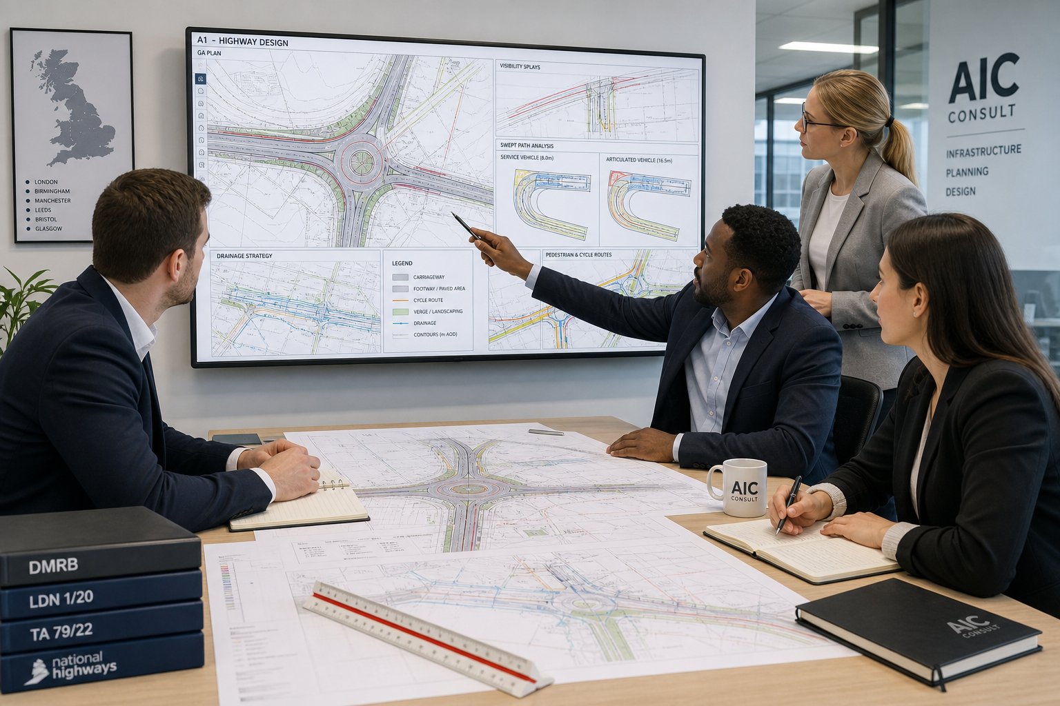
A robust highway design package does more than show a road in plan. It explains how the highway will function, fit the site, and comply with relevant standards. The exact content depends on the stage of the project, but most packages include horizontal and vertical geometry, access and junction arrangements, levels, visibility, tracking, pedestrian and cycle provision, drainage coordination, and signs or lining where needed.
At planning stage, the package may be relatively lean but still needs to be convincing. At technical approval stage, it becomes more detailed and coordinated with earthworks, utilities, structures, landscaping, and drainage. The point isn’t to produce drawings for their own sake. It’s to answer the practical questions the authority, design team, and contractor will ask next.
We also find that a good package is iterative. Rarely does the first layout survive unchanged. Building footprints shift, refuse strategies evolve, tree constraints emerge, and levels become more complex once surveys are reviewed. That’s normal. What matters is having an engineering process that tests options quickly and keeps the wider team aligned.
For access-heavy schemes, early input from Junction Design Consultants can be especially useful where a new arm, ghost island, mini-roundabout, or signalised solution is under discussion.
Junction Layouts, Visibility Splays, Tracking, And Drainage Coordination
Junction layouts are one of the first things highways officers look at. The geometry has to work not just on paper but in traffic operation, user behaviour, and maintenance terms. We consider entry widths, radii, deflection, lane discipline, pedestrian crossing points, and how the junction ties into the surrounding network.
Visibility splays are another recurring issue. It’s not enough to draw a triangle and assume it works. We need to check actual measured speeds where appropriate, boundary features, vegetation, level differences, and whether the required land is within control or can be secured.
Swept-path analysis then tests whether refuse wagons, fire appliances, articulated vehicles, and delivery vans can manoeuvre safely. This is often where apparently minor design assumptions start to wobble.
Drainage coordination matters just as much. Highway levels need to work with onsite drainage strategy, exceedance routes, and SuDS constraints. If they don’t, ponding, awkward gradients, or redesign can follow very quickly.
Standards, Guidance, And Local Authority Requirements That Shape Design

Highway design in the UK is shaped by a layered mix of national standards, good-practice guidance, and local interpretation. The core references often include DMRB for trunk road and strategic road contexts, Manual for Streets and Manual for Streets 2 for more urban and development-led environments, the Traffic Signs Regulations and General Directions, local parking standards, cycling design guidance, and authority-specific highway design guides.
But the real-world challenge isn’t just knowing the documents exist. It’s understanding which ones carry most weight on a particular site. A suburban housing access onto a local road won’t be approached in the same way as a strategic employment site near a principal route. Some councils are relatively flexible if a design can justify itself well. Others are highly prescriptive on geometry, tracking, bin collection routes, or active travel provision.
This is why local knowledge has practical value. The same broad policy framework applies nationally, yet threshold expectations for Transport Statements, visibility assumptions, parking ratios, and adoptable details can vary. Teams working on region-specific schemes often benefit from experience with local reviewers, whether that’s through Manchester Highway Engineering or similar authority-facing project work elsewhere.
We also need to keep pace with policy updates. In 2026, design scrutiny around active travel, accessibility, climate resilience, and place quality is stronger than it was a few years ago. A layout that only “fits the cars” is rarely enough now.
Road Safety, Accessibility, And Active Travel In Modern Highway Design
Modern highway design has moved well beyond simply accommodating vehicle movements. Safety, accessibility, and active travel are now central design considerations, and rightly so. Local authorities increasingly expect developments to demonstrate that people can reach and move around a site safely whether they walk, wheel, cycle, use public transport, or drive.
Road safety starts with geometry, visibility, speed environment, and conflict reduction, but it doesn’t stop there. We often review how access points interact with desire lines, whether pedestrian crossing locations are legible, how service movements affect vulnerable users, and whether the design is likely to generate awkward driver behaviour. On some projects, independent Road Safety Audits will be required at specific stages, and good designers anticipate the likely audit points early.
Accessibility is equally important. Inclusive design means considering gradients, dropped kerbs, tactile paving, crossing widths, waiting areas, and the overall readability of routes. A technically compliant layout can still feel hostile if footways pinch, crossings are indirect, or mobility-impaired users are treated as an afterthought.
Active travel provision has also become more policy-led. Secure walking and cycling connections, direct links to surrounding networks, and sensible integration with bus access are now expected on many schemes. This is often where highway design intersects with wider Transport Planning Consultants: What teams, especially when modal shift and sustainable travel measures need to be evidenced as part of the application.
Common Design Challenges On Development Sites
Most development sites look cleaner on a location plan than they do in reality. Existing trees crowd the boundary. Levels fall away sharply. Utilities sit exactly where the bellmouth wants to go. A neighbouring wall blocks visibility. The drainage outfall is inconveniently uphill, somehow. None of that is unusual.
Restricted visibility is one of the most common stumbling blocks, particularly on infill and roadside plots. Achieving suitable splays can require land dedication, wall removal, vegetation management, or changes to the access position. Tight site boundaries can also make vehicle tracking difficult, especially where refuse, fire, and service vehicles all need different turning envelopes.
Level changes create another layer of complexity. Steep access gradients can affect usability, drainage, and visibility. Coordinating highway levels with finished floor levels, retaining features, and attenuation areas takes careful design, not last-minute patching.
Capacity constraints at nearby junctions can also push a project towards mitigation, whether through geometric improvement, signal optimisation, or a different access strategy. And then there’s the everyday balancing act between parking numbers, servicing, public realm, landscaping, and active travel routes. Pull one lever and another moves.
This is why early optioneering matters. When we can test constraints with architects and planners before a layout hardens, we usually save clients time, redesign cost, and a fair bit of frustration.
How Highway Design Consultants Work With Architects, Planners, And Developers
Highway design works best as part of an integrated design team, not as a bolt-on after the masterplan is “finished”. In practice, we work iteratively with architects, planners, developers, surveyors, drainage engineers, and sometimes lawyers to make sure the highway solution is both policy-compliant and buildable.
At concept stage, we often test multiple access options, compare junction forms, assess likely tracking constraints, and flag land or visibility issues that may influence site layout. Architects can then shape building massing and frontage treatment around realistic highway geometry rather than optimistic assumptions. Planners, meanwhile, can align the submission strategy with what the local authority is likely to ask for.
As the scheme progresses, we attend design team meetings, support pre-app discussions, and respond to comments from the local highways authority. That responsiveness matters. A well-judged technical note or revised drawing at the right moment can unlock weeks of delay.
For planning-led projects, our role frequently overlaps with broader traffic and access evidence, which is why teams may also draw on Traffic Engineering Consultants: What alongside detailed highway design input.
Where a site is in a location with very specific local expectations, familiarity with the reviewing authority can smooth the process. That’s one reason some clients seek regionally focused support from highway design consultants Birmingham or equivalent local specialists rather than relying only on generic national advice.
What To Prepare Before Appointing A Highway Design Consultant
Clients get faster, better advice when the basics are ready at the start. That doesn’t mean every issue must be solved before we’re appointed, far from it, but a solid information pack avoids early guesswork.
The essentials usually include a red-line boundary plan, a recent topographical survey, any initial site layout or masterplan, and copies of pre-app or highway authority correspondence if those conversations have already started. If planning constraints are known, such as trees, listed features, rights of way, easements, utility corridors, flood risk issues, or visibility land ownership concerns, bring those in early too.
It also helps to clarify the intended planning route and programme. Is the immediate need a feasibility sketch, a planning-stage access drawing, a Transport Statement input, or detailed S278 or S38 design? The answer affects scope, fee, and sequencing.
We’d also suggest assembling any available traffic data, existing junction drawings, accident information where relevant, and site servicing requirements. Knowing whether the site needs articulated deliveries, bus access, or oversized plant movements can alter design assumptions from day one.
If the project team is still defining responsibilities, it can be useful to understand how the highway consultant will coordinate with drainage, transport planning, and masterplanning. That’s often where broader Transport Planning Consultants: support sits alongside design input.
How To Choose The Right Highway Design Consultant For Your Project
Choosing the right consultant is partly about technical competence and partly about fit. Plenty of engineers can draw a junction. Fewer can spot planning risks early, explain trade-offs clearly, and keep a project moving when authority comments land.
We’d start with relevant experience. Has the consultant worked on schemes of similar scale and use type? Do they understand planning-stage support as well as detailed design for delivery? Can they handle both the report interface and the drawing package? For many clients, that breadth is what reduces handoffs and inconsistency.
Next, look at local authority familiarity. A consultant who understands the standards, thresholds, and review style of the authority involved can often frame submissions more effectively. Ask how they approach pre-app engagement, technical approvals, and responses to objections.
Capacity matters too. A good fee isn’t much use if the programme slips because the team is overstretched. Ask who will actually do the work, who will review it, and how revisions are managed. Communication style counts here more than people admit.
Finally, assess collaboration. Highway design touches architecture, drainage, planning, and delivery, so the right consultant needs to be practical, responsive, and comfortable challenging the scheme when needed. In our experience, the best outcomes come from teams that combine technical accuracy with commercial awareness, exactly the sort of approach clients value when concise, authority-ready outputs are needed quickly.
The right appointment won’t remove every planning or delivery risk. But it will make those risks visible earlier, easier to manage, and far less likely to derail the project at the worst possible moment.
Frequently Asked Questions About Highway Design Consultants
What do highway design consultants do and when should you hire one?
Highway design consultants are specialist civil and transport engineers who plan and design road geometry, junctions, drainage, and access arrangements. You need one when a development impacts access, parking, traffic operations, or requires highway works related to planning applications.
How do highway design consultants support planning applications?
They provide detailed access drawings, junction layouts, and technical evidence to demonstrate safe and suitable site access. Early design input helps reduce objections and aligns schemes with national guidance and local authority requirements, improving planning approval chances.
What typical projects require highway design input?
Projects include residential and mixed-use developments, commercial sites like retail parks and industrial estates, link roads, bypasses, and estate road adoptions. Even small sites with constrained access or visibility issues often need design consultancy to ensure compliance and safety.
What is included in a robust highway design package?
A highway design package typically features horizontal and vertical geometry, junction arrangements, visibility splays, swept-path tracking, pedestrian and cycle facilities, drainage coordination, and signage. This package evolves from concept stage to detailed technical approval to answer all operational questions.
What are Section 278 and Section 38 works in highway design?
Section 278 involves works on the existing public highway like access amendments or road widening, while Section 38 covers adoption of new estate roads built to local authority standards. Design consultants prepare detailed plans and coordinate approvals for these legal agreements.
Why is local authority knowledge important for highway design consultants?
Local authority preferences vary significantly in standards for geometry, parking, drainage, and active travel. Consultants familiar with specific council requirements and review styles can better frame submissions, avoid redesigns, and streamline approval processes, especially for complex or region-specific projects.