Traffic Engineer In Bournemouth: Planning Support, Local Insight, And Faster Transport Reports In 2026
Planning applications rarely fail because the architecture is weak on paper. More often, they stall because the transport case is thin, late, or not properly aligned with local expectations. In Bournemouth, that matters more than many teams first assume. A site can look straightforward until access geometry, parking stress, seasonal traffic, refuse tracking, or sustainable travel objections start to unravel the programme.
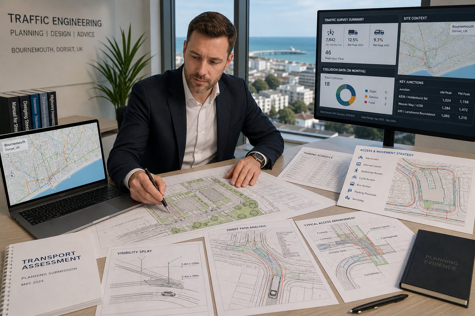
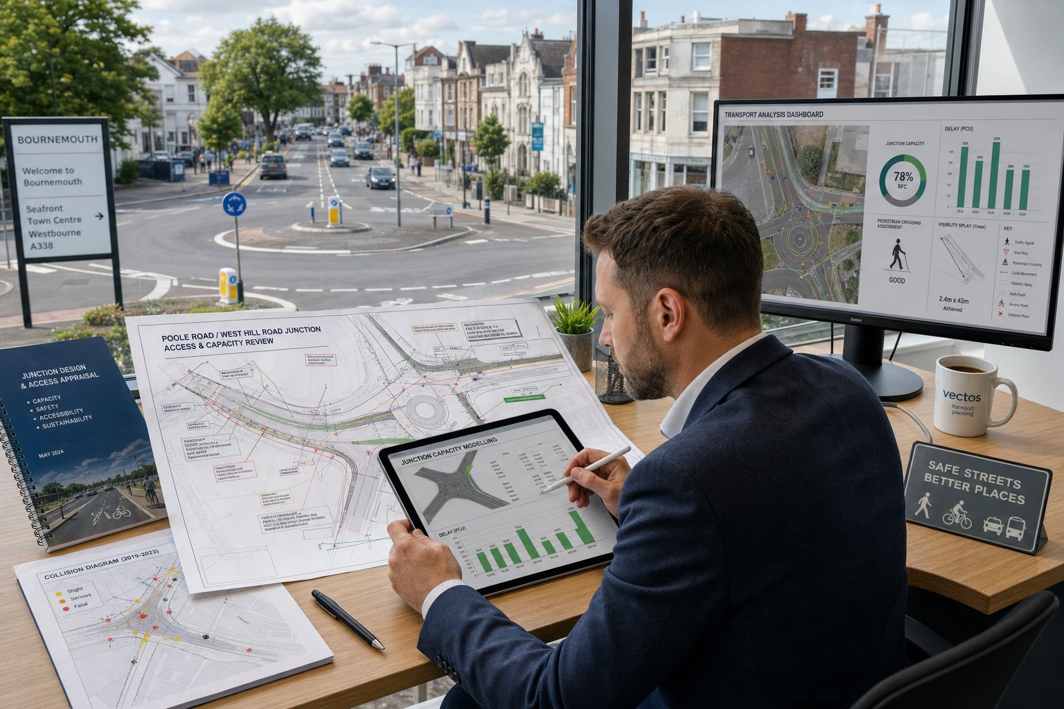
That is where a traffic engineer in Bournemouth becomes valuable. We prepare the transport evidence that helps architects, planners, developers, surveyors, lawyers, and local authorities move from a concept drawing to a defensible planning submission. That can mean a concise Transport Statement for a modest infill scheme, a detailed Transport Assessment for a major mixed-use proposal, or a Travel Plan that responds to policy and planning conditions.
The key is not simply producing a report. It is producing the right report, at the right depth, with assumptions that Bournemouth, Christchurch and Poole Council is likely to recognise as reasonable, policy-compliant, and technically robust. In practice, that means understanding local road constraints, parking standards, active travel expectations, and when a scheme needs formal junction modelling rather than broad narrative.
In this guide, we set out what a traffic engineer does, when particular transport documents are needed, how impact is assessed, and what commonly causes delay. If you are assembling a planning team in 2026, getting transport advice in early usually saves far more time than it costs.
Key Takeaways
- Engaging a traffic engineer in Bournemouth early in the planning process ensures transport reports align with local policies and reduce application delays.
- Transport evidence must be tailored to Bournemouth’s unique conditions, including local road constraints, parking standards, and seasonal traffic variations.
- Choosing between a Transport Assessment, Statement, or Travel Plan depends on the scale and impact of the development, with professional guidance critical to avoid under- or over-scoping.
- Accurate trip generation, junction capacity analysis, and access design contribute to meeting Bournemouth’s safety and sustainable travel standards.
- Collaboration among architects, planners, developers, and traffic engineers enhances proposal viability by addressing key transport and servicing considerations from concept to submission.
- A clear, evidence-backed transport report that addresses local concerns and policies is essential for a smoother planning determination in Bournemouth.
What A Traffic Engineer In Bournemouth Does For Planning Applications
For planning work, our role is broader than many clients expect. We do not only forecast vehicle trips. We review how a proposal sits within the surrounding highway network, how people are likely to arrive by different modes, whether the access is safe, and whether the development can be served, parked, and operated without creating unacceptable effects.
At the start of an instruction, we usually test five things. First, the planning context: local plan policies, parking standards, active travel expectations, and any site-specific history. Second, the physical context: junction form, visibility, footway continuity, crossing opportunities, bus access, and servicing constraints. Third, the scale of likely impact: whether the scheme points toward a Transport Statement, full Transport Assessment, or a lighter technical note. Fourth, data needs: surveys, collision records, speed data, parking beat surveys, or junction counts. Fifth, mitigation: what can realistically be adjusted in the layout before positions harden.
That early stage is where experience pays off. A capable team will often refine a red-line boundary, access location, parking arrangement, or swept-path layout before an objection is drafted. Our approach follows the same practical principles described in broader work on Traffic Engineering Consultants: What and reflects the wider discipline set out in Traffic Engineering: Your Complete.
In Bournemouth specifically, a traffic engineer also translates local authority expectations into a submission strategy. That includes deciding what must be evidenced in detail and what can properly be addressed proportionately.
When You Need A Transport Assessment, Transport Statement, Or Travel Plan
Not every development needs the same level of transport evidence. One of the most common reasons applications slow down is that the wrong document is submitted at the outset.
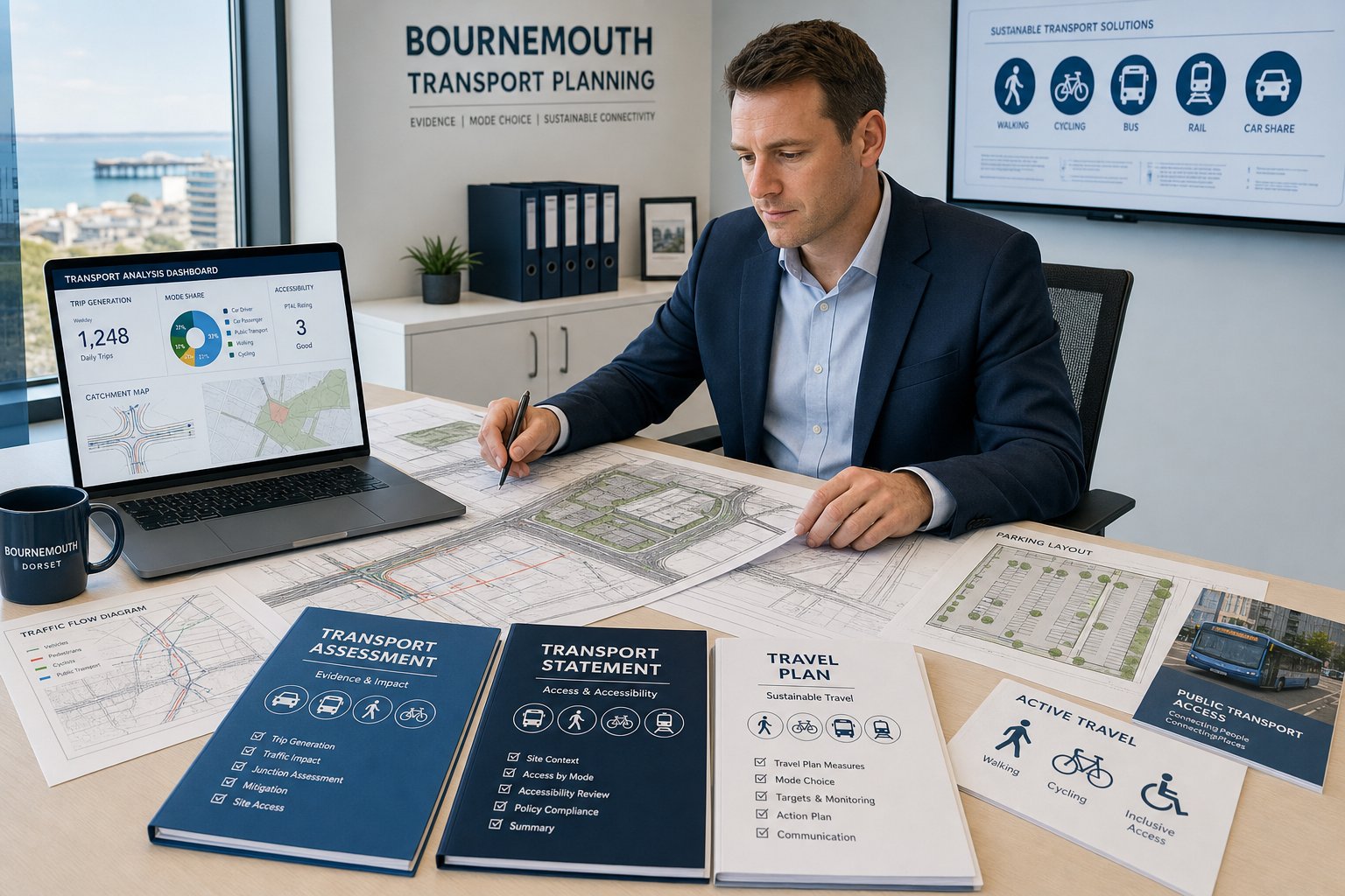
A Transport Assessment is usually needed where a scheme could create material transport effects. That often includes larger residential developments, food retail, employment uses, schools, care schemes, or mixed-use proposals that intensify movements at already sensitive locations. A TA goes beyond a description of the site. It normally includes baseline conditions, trip generation, trip distribution, assignment, capacity testing where justified, servicing review, parking analysis, accessibility, and mitigation.
A Transport Statement is a more proportionate document for smaller or less impactful proposals. It still needs to be evidence-led, but it is generally shorter and less model-heavy. For example, a modest redevelopment with acceptable access, limited additional trips, and no obvious network stress may be well suited to a TS.
A Travel Plan is different again. It is about behaviour and mode choice rather than pure impact. Schools, workplaces, larger residential developments, and some town-centre schemes may need one either at application stage or by condition. That document sets out targets, measures, monitoring, and management arrangements to encourage walking, cycling, public transport use, car sharing, or reduced single-occupancy car trips.
In practice, we advise clients to scope the document against thresholds, local sensitivity, and likely consultation issues rather than unit numbers alone. That is especially important on commercial sites, where operational patterns can matter more than gross floorspace, a theme also explored in Commercial Traffic Engineering In.
How Bournemouth Planning And Highway Requirements Shape Transport Evidence
In Bournemouth, transport evidence is shaped by both national guidance and the local planning and highway context. BCP Council will typically want to understand not only whether a development adds traffic, but whether it does so in a way that is safe, policy-compliant, and compatible with local sustainable travel aims.
That affects scope from day one. Parking provision must reflect local standards rather than generic assumptions. Access arrangements need to respond to street type, frontage activity, nearby junctions, pedestrian movement, and the character of the area. The evidence base may also need to engage with cycling connectivity, bus accessibility, and town-centre walkability, especially where reduced parking is proposed.
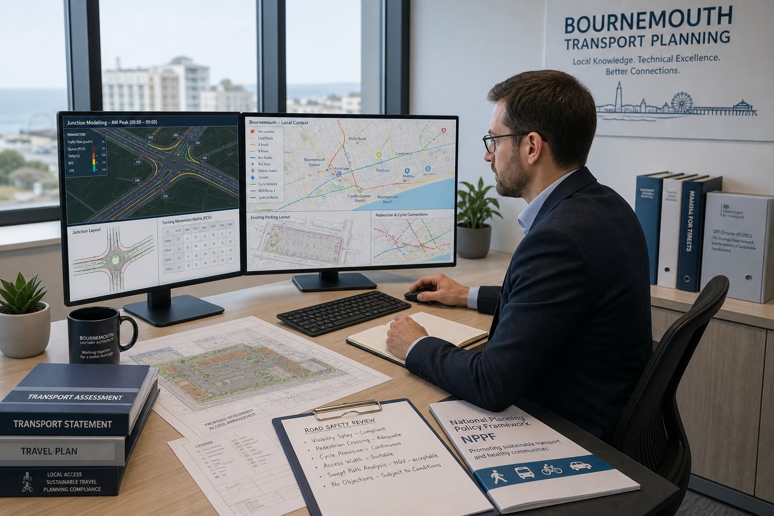
Local requirements can also influence methodology. For one site, a simple peak-hour trip review may be enough. For another, the authority may expect capacity modelling, queue review, collision analysis, a Stage 1 Road Safety Audit, or clearer demonstration of why particular trip rates are robust. If a scheme sits near sensitive residential streets, schools, seafront routes, or constrained corridors, the threshold for technical scrutiny often rises.
This is why transport reporting cannot be copied from one authority to another. The framing used for a Bournemouth application may differ significantly from approaches that work elsewhere, even though the underlying discipline is similar to work we deliver for teams reading Traffic Engineering and Transportation or location-specific pieces such as Traffic Engineer In Bristol:.
The Difference Between A Transport Assessment And A Transport Statement
The distinction matters because under-scoping can trigger delay, while over-scoping can waste time and budget.
A Transport Assessment is the fuller technical document. It usually covers development details, policy review, baseline transport conditions, multi-modal accessibility, trip generation, distribution and assignment, operational impact, parking, servicing, mitigation, and often junction modelling using software such as ARCADY, PICADY, LINSIG, SIDRA, or in some cases microsimulation. It is the right tool when decision-makers need to understand whether a development has a significant effect and how that effect can be managed.
A Transport Statement is shorter and more proportionate. It still examines baseline conditions and proposed access, and it still justifies trip forecasts, but the impact review is higher level. A TS is often suitable where the proposal is smaller, the road network context is less constrained, and there is no credible basis to expect severe transport consequences.
The practical question is not which title sounds easier. It is which level of evidence will withstand scrutiny once planning, highway, and third-party comments arrive.
How A Traffic Engineer Assesses Trip Generation, Distribution, And Impact
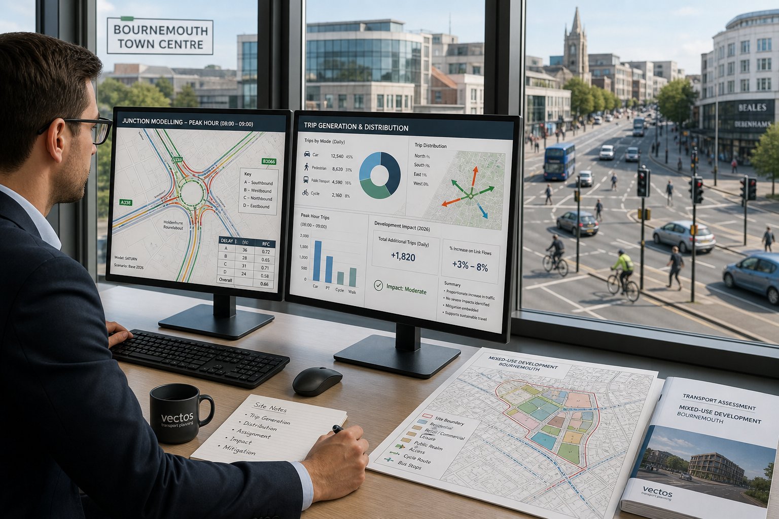
Trip generation is where transport evidence becomes quantitative. We estimate how many person trips and vehicle trips a development is likely to create, when those trips occur, and how they compare with the site’s existing or lawful use.
That work usually starts with an agreed development schedule and a clear definition of peak periods. We then draw on recognised databases and comparative survey evidence, adjusting for local context rather than applying raw rates blindly. In some cases, existing use credit is highly material. A site moving from one active commercial use to another may generate less net impact than headline floorspace suggests.
Distribution and assignment come next. We consider where trips are likely to come from and go to using census journey patterns, local network logic, observed turning movements, catchment characteristics, and route choice. For mixed-use development, internal trip capture may also be relevant. For town-centre sites, non-car mode share needs proper attention: assuming every trip arrives by private car is both unrealistic and poor planning evidence.
Impact is then tested proportionately. Sometimes that means a straightforward comparison of forecast flows against baseline conditions. Sometimes it means formal modelling of nearby junctions in the relevant peak hours, sensitivity tests, or queue review. We are looking for a grounded answer to two questions: does the development create a material operational issue, and if so, what mitigation is sensible?
The best transport work is rarely about generating the most spreadsheets. It is about using the right level of analysis to answer the planning question clearly, defensibly, and without leaving obvious gaps.
Junction Capacity, Access Design, And Highway Safety Considerations
For many schemes, the decision turns on access and safety rather than headline trip totals. A development can generate a modest number of trips and still face objection if vehicles cannot enter and leave safely, if visibility is poor, or if the nearest junction is already performing badly.
Junction capacity work examines whether additional traffic is likely to create unacceptable queues, delay, or reserve capacity problems. The modelling tool depends on the junction form: priority junctions often use PICADY, roundabouts ARCADY, signals LINSIG, and more complex scenarios may need SIDRA or microsimulation. But software is only part of the story. Inputs, survey quality, growth assumptions, and network logic matter just as much.
Access design is more physical. We review width, radii, gradient, forward visibility, pedestrian crossing points, cycle interaction, and how the proposed entrance sits relative to bends, parking, trees, or neighbouring accesses. Manual for Streets principles often come into play, especially on urban streets where balancing vehicle movement with placemaking and pedestrian safety is essential.
Collision history can also shape the response. If there is a pattern of turning, shunt, or pedestrian incidents nearby, the authority may expect a stronger case that the proposal does not worsen an existing issue. In some cases, a Road Safety Audit is prudent even before it is formally requested.
And this is where early layout testing helps. Small geometric changes made at concept stage often avoid much larger redesigns later, particularly on tight urban plots or sites with ambitious density targets.
Parking, Servicing, Refuse Collection, And Delivery Movements
Parking and servicing are easy to underestimate because they feel operational rather than strategic. In planning terms, they are often central.
Parking provision in Bournemouth must be justified against local standards, site accessibility, use class, and development type. Too little parking can prompt concerns about overspill onto surrounding streets. Too much can conflict with design quality, viability, and sustainable travel objectives. The right answer is rarely a simple maximum or minimum figure: it depends on context, nearby controls, likely car ownership, visitor demand, and the practical layout of the site.
Servicing can be even more decisive. We assess what vehicles need to access the site, how often, and whether they can manoeuvre safely. That usually includes delivery vans, rigid lorries where relevant, emergency access, and refuse vehicles. Swept-path analysis is often required to prove that vehicles can enter, turn, load, and leave in forward gear where necessary.
Refuse strategy is a common pressure point on constrained sites. If bins have to be dragged excessive distances, if collection vehicles would need to reverse unsafely, or if collection blocks the highway, planning officers and highways colleagues will notice.
For commercial and mixed-use development, loading bay placement, timing restrictions, and management plans may all become part of the package. The same themes recur across urban authorities, whether teams are comparing Bournemouth issues with Traffic Engineer In London: or the logistical patterns discussed in Traffic Engineer In Leeds:.
A transport submission that ignores servicing details is often incomplete, even if the trip generation work is otherwise sound.
Sustainable Travel, Accessibility, And Active Travel Expectations
Transport evidence in 2026 is not just about cars. BCP, like most authorities, expects planning submissions to show how a site supports walking, cycling, public transport use, and realistic travel choice.
That means we assess more than distance to the nearest bus stop. We look at route quality, crossing facilities, footway continuity, gradients, lighting, wayfinding, cycle links, secure cycle parking, and whether key day-to-day destinations are genuinely accessible without driving. A site may be geographically close to services but still perform poorly if the pedestrian route is indirect or unpleasant.
For some developments, active travel measures are straightforward: cycle parking, welcome packs, travel information, shower facilities, or public transport contribution. For others, more structured mitigation is needed, such as a Travel Plan coordinator, monitoring framework, car club provision, or targeted incentives for residents or staff.
What matters is credibility. Decision-makers are increasingly sceptical of generic claims that a scheme is “sustainable” without evidence. If reduced parking is proposed, the active travel narrative has to be convincing. If a site is edge-of-centre or on a constrained corridor, the submission should show exactly how non-car trips can work in practice.
Well-prepared accessibility work often does more than satisfy policy wording. It can strengthen the overall planning balance by demonstrating that the proposal supports healthier, lower-impact travel patterns rather than simply accommodating vehicle demand.
Key Local Factors In Bournemouth That Can Affect A Transport Report
Bournemouth has transport characteristics that can materially affect how a report should be prepared. Treating it like a generic South Coast location is a mistake.
The first factor is the network itself. Some corridors are constrained, heavily trafficked, or sensitive to relatively small changes in peak-hour flow. That can make junction performance and routing assumptions more important than on a site served by a robust strategic road. The second is seasonality. Tourism, seafront activity, event traffic, and school holiday patterns can distort what “typical” conditions really mean, so survey timing and interpretation need care.
The third factor is urban character. Bournemouth includes residential streets where parking stress, rat-running concerns, and pedestrian amenity can quickly become planning issues even when absolute trip numbers are not dramatic. The fourth is air quality and wider environmental sensitivity. On some corridors, an authority may expect a clearer explanation of how the proposal avoids worsening existing pressure.
Topography and connectivity also matter. A theoretical cycle catchment on a flat map can look very different on the ground. Bus accessibility may be strong in one part of the town and much weaker in another. And town-centre, suburban, and edge locations each demand different assumptions about mode share.
These local variables are exactly why experience in multiple authorities helps: it sharpens judgement about what is site-specific, what is policy-led, and what evidence must be tailored rather than recycled.
Working With Architects, Planners, Developers, And Local Councils
The strongest planning outcomes usually come from collaboration, not from transport advice being bolted on at the end. We work best when we are part of the design conversation early, alongside architects, planning consultants, developers, surveyors, and legal teams.
At concept stage, transport input can shape access position, internal circulation, parking ratio, cycle storage, service yard layout, and even unit mix. That is often where the biggest value sits. If the first fixed layout leaves no room for refuse turning or compliant visibility splays, the reporting task becomes defensive rather than strategic.
Pre-application engagement can also be useful, especially for larger, contentious, or unusual sites. A short, focused note to BCP highways or planning officers can help establish whether the authority is likely to expect a TA, what junctions should be assessed, whether survey updates are needed, and how sustainable travel should be addressed. It does not remove all risk, but it often narrows the scope for avoidable disagreement.
Coordination across disciplines matters too. Drainage features can affect visibility. Landscaping can affect sightlines. Servicing arrangements can affect acoustic design. Legal rights of access can alter the transport strategy entirely. Good project teams spot those overlaps early.
Our experience across different local authority contexts, including work analogous to Traffic Engineer In Manchester: and other planning-led commissions, helps us keep transport advice practical rather than siloed.
Common Reasons Transport Submissions Are Delayed Or Challenged
Most challenged submissions are not rejected because transport engineering is inherently contentious. They are challenged because something basic was missed.
A frequent issue is poor scoping. If the authority expected a Transport Assessment and receives a thin Statement, objections are predictable. The reverse problem also happens: an overly elaborate report that still fails to answer the actual local concern. Another common issue is weak data. Out-of-date traffic counts, incomplete speed surveys, missing parking observations, or unsupported trip rates can undermine confidence very quickly.
Assumptions are another pressure point. If mode share, trip distribution, or servicing demand appears optimistic without evidence, consultees will test it hard. Local standards are often mishandled too, especially on parking and cycle provision. We also regularly see schemes where walking, cycling, and public transport are dealt with in a token paragraph rather than a meaningful accessibility review.
Timing causes delays as well. Transport work instructed after the layout is effectively final tends to expose problems that are expensive to solve. Tight programmes can then force rushed surveys or reactive redesign.
Perhaps the biggest issue, though, is lack of narrative. A report can contain all the right tables and still fail if it does not explain why the development is acceptable in planning terms. Decision-makers need analysis, but they also need a coherent professional judgement that connects the numbers to the site and policy context.
What To Prepare Before Instructing A Traffic Engineer
A good instruction starts with good information. The more clearly the project team defines the site and proposal, the faster we can advise on scope, risks, likely surveys, and reporting programme.
At minimum, we usually need:
- a red-line site plan
- a draft layout or access sketch
- proposed use classes and development schedule
- unit numbers, GIA, or floorspace as relevant
- details of existing or lawful use
- any planning history or appeal material
- pre-application advice, if already obtained
- target submission date and decision pressures
- known site constraints, including rights of way, land ownership, level changes, trees, or frontage restrictions
If available, it also helps to have early architectural drawings, swept-path aspirations, parking assumptions, and any viability pressures that may affect layout options. For phased schemes, we need clarity on what is sought now and what is reserved.
We then advise on the likely level of reporting, surveys, modelling, and whether pre-app dialogue is sensible. At ML Traffic, that front-end clarity is one reason clients come to us for concise, accurate reports on demanding programmes. It lets us match the evidence to the scheme rather than produce generic transport paperwork.
Put simply, the better the instruction, the fewer surprises later. And in planning, fewer surprises usually means faster progress.
Conclusion
Transport evidence can make or break a planning application long before committee. In Bournemouth, where local highway conditions, parking expectations, seasonal demand, and sustainable travel policy all influence the outcome, a generic report is rarely enough.
Using a specialist traffic engineer in Bournemouth early helps reduce that risk. We can identify whether a scheme needs a Transport Assessment, Transport Statement, Travel Plan, junction modelling, servicing review, or simply a better layout before the application is submitted. More importantly, we can align the technical case with what BCP and wider planning policy are likely to expect.
For architects, planners, developers, surveyors, lawyers, and councils, the practical goal is simple: proportionate, robust transport evidence that answers the real questions first time. That is usually the quickest route to a stronger application and a smoother determination process.
Frequently Asked Questions about Traffic Engineers in Bournemouth
What services does a traffic engineer in Bournemouth provide for planning applications?
A traffic engineer in Bournemouth reviews site access, assesses local highway conditions, and prepares essential transport evidence like Transport Assessments, Transport Statements, and Travel Plans to ensure planning applications meet Bournemouth, Christchurch and Poole Council requirements and national guidance.
When is a Transport Assessment required instead of a Transport Statement in Bournemouth?
A Transport Assessment is needed for larger or more impactful developments that may significantly affect local traffic, such as major residential or retail projects. Smaller schemes with limited transport impact usually require a more concise Transport Statement suitable for less complex proposals.
How does Bournemouth’s local planning policy affect transport evidence?
Bournemouth’s local planning policies influence parking standards, sustainable travel expectations, and road safety requirements. Transport evidence must address local issues like junction capacity, access design, and promote active travel to align with the Bournemouth, Christchurch & Poole Council’s objectives for safe and sustainable developments.
What factors can delay or challenge transport submissions in Bournemouth?
Common causes of delays include submitting the wrong transport document, inadequate local data, unsupported assumptions on trip generation or mode share, neglecting walking and cycling considerations, and late transport advice after layouts are fixed, leading to costly redesigns or objections by the council.
How can early involvement of a traffic engineer benefit a Bournemouth planning application?
Engaging a traffic engineer early helps shape site layouts, access points, and parking arrangements to comply with local standards, reducing risk of refusals or delays. Early input supports effective pre-application discussions with BCP Highways, aligning transport evidence with policy and making applications stronger and smoother to determine.
What should developers prepare before instructing a traffic engineer in Bournemouth?
Developers should provide a red-line site plan, draft layouts, proposed use classes, unit counts or floorspace, existing use details, any planning history, known site constraints, and target submission dates. This information enables accurate scoping of Transport Assessments or Statements tailored to Bournemouth’s local requirements.