Access design in highway engineering tends to look simple on a planning drawing right up until it becomes the reason an application stalls. A new bell-mouth, a relocated gate, a widened crossover, a side road serving twenty homes, on paper, these can appear minor. In practice, they sit at the point where private development meets the public highway, which means they attract close scrutiny from highway officers, planning case teams, lawyers, designers and, sometimes, objectors.
That scrutiny is justified. Poorly designed access can increase collision risk, interrupt pedestrian movement, create drainage problems, slow the main road and leave a scheme with a technically awkward layout that is expensive to build. Good access design does the opposite: it helps demonstrate that a development can operate safely, fit local policy, and win planning approval without unpleasant surprises later in detailed design.
In this guide, we explain what access design in highway engineering actually covers, which standards usually shape it in the UK, and why vehicle tracking, visibility, gradients, drainage, inclusive movement and nearby junction performance all matter. We are writing with planning applications in mind, so the focus is practical: what local authorities typically look for, what commonly delays approval, and what transport evidence usually needs to be submitted. For architects, planners, developers and councils, getting this right early usually saves both time and argument.
What Access Design Means In Highway Engineering
Access design in highway engineering is the process of planning how vehicles, pedestrians and cyclists enter and leave a site from the public highway while keeping the surrounding network safe and functional. That sounds broad because it is. It can involve a single dwelling crossover, a farm access, a shared private drive, a commercial yard entrance or an entirely new side road serving a wider development parcel.
At its core, access design is about the interface between land use and road function. Not every road should accept the same form or frequency of access. Motorways permit no direct frontage access. Strategic routes are tightly controlled. Local streets, by contrast, usually tolerate a greater number of driveways and minor junctions. So the first design question is not only “can we get in and out?” but “is this road an appropriate place to do so?”
The answer then shapes the layout: location, number of access points, junction type, geometry, visibility, gradients, surface treatment and accommodation for non-motorised users. On larger schemes, it also influences whether access is designed as a simple priority arrangement or as a more formal junction.
For planning work, the exercise is rarely isolated. It sits alongside broader Access Strategy Transport thinking, land constraints, rights over third-party frontage, and the operational expectations of the highway authority. In other words, access design is not just a kerbline detail. It is one of the earliest technical tests of whether a development is realistically deliverable.
Why Access Design Matters For Planning Approval, Safety And Operation
Planning authorities generally want evidence that a development will not create an unacceptable impact on highway safety or cause severe operational harm to the road network. Access design is where those questions often become tangible. If the point of access is flawed, the rest of the transport case can quickly unravel.
From a planning approval perspective, a well-designed access shows that development traffic can enter and leave the site in a controlled way, that the junction form suits the forecast demand, and that the proposal aligns with local standards. It also helps demonstrate buildability. Officers are often wary of “illustrative” access drawings that ignore retaining walls, levels, visibility obstructions or land ownership.
Safety is the second major reason it matters. Every access creates conflict points: turning vehicles crossing traffic, pedestrians moving over side road mouths, cyclists continuing along the frontage, and drivers making judgements on gap acceptance. Better access management typically reduces those conflict points and the severity of resulting collisions. Spacing, speed environment, turning provision and sight lines all play a part.
Operationally, access can affect far more than the site boundary. An awkward right-turn movement on a busy road may increase delay. A poorly spaced access can interfere with a nearby roundabout. A commercial entrance without adequate internal holding space may push queues back into the carriageway. That is why Junction And Access Design is so often considered alongside the wider corridor rather than as a stand-alone feature.
And yes, sometimes a technically acceptable access still fails the planning smell test if it feels at odds with the street, the frontage or the movement patterns around it.
Core Design Standards And Guidance That Shape Access Layouts
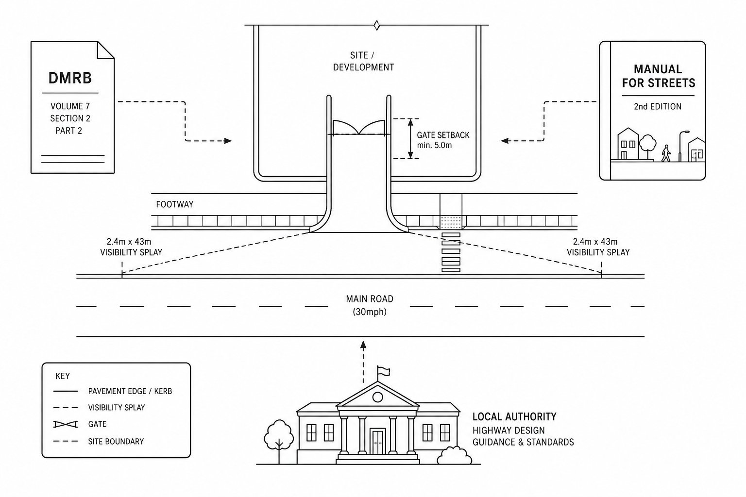
In the UK, access design is usually shaped by a combination of national guidance, local highway authority standards and site-specific judgement. The exact hierarchy depends on the road type and who will adopt or maintain the infrastructure.
For trunk roads and the strategic road network, the Design Manual for Roads and Bridges, or DMRB, is normally the starting point. Its standards are stricter because the roads carry higher speeds, higher flows and more strategic movement. Direct access onto such routes is often resisted unless there is a compelling operational and safety case.
For local roads, Manual for Streets and Manual for Streets 2 remain influential, especially where development fronts onto lower-speed urban streets. Their approach is broader than geometry alone. They consider context, place function, pedestrian movement and the quality of the street environment, which matters when designing accesses in built-up areas.
Local design guides then add another layer. County councils, unitary authorities and London boroughs commonly publish standards on visibility splays, gradients, crossover widths, refuse access, parking aisle dimensions and accessibility requirements. These documents can differ in useful but awkward ways. One authority may accept a tighter domestic access gradient than another. One may insist on a particular setback for gates. Another may be especially strict on access spacing from junctions.
That is why our approach is usually to align national guidance with local interpretation from the start. On more complex sites, Highway Design Consultants: experience helps avoid the classic problem of designing to a generic standard that the determining authority simply does not use in practice.
How Vehicle Type, Traffic Demand And Land Use Influence Access Design
No access should be designed in a vacuum. The right form depends heavily on who is using it, how often they are using it and what the site is actually for.
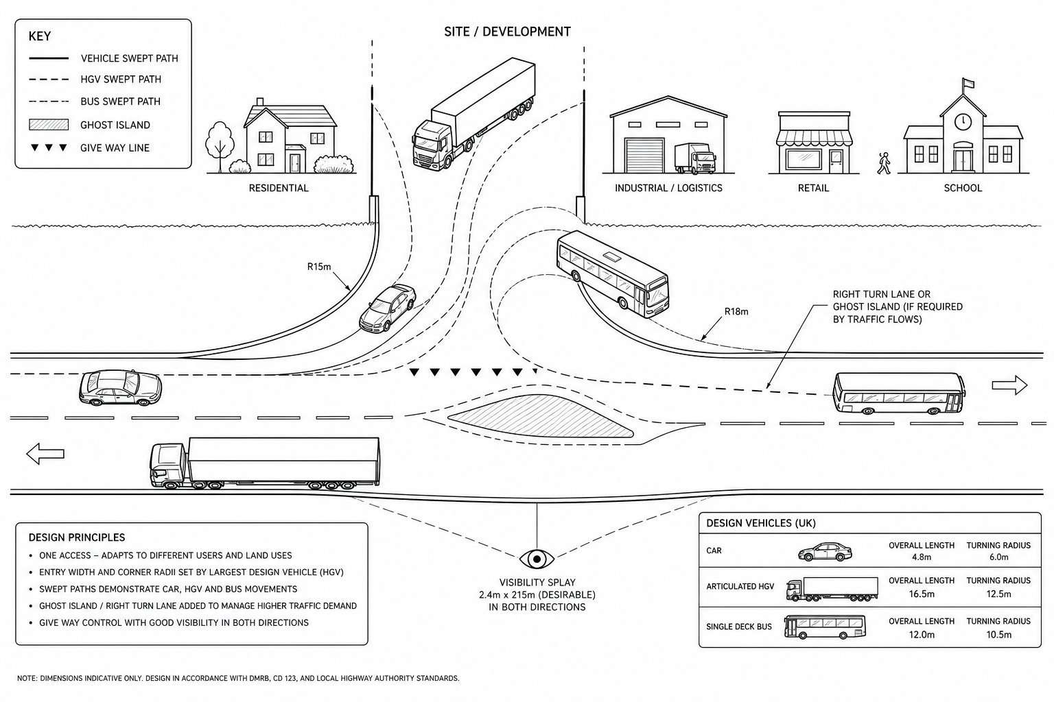
Vehicle type matters first. A residential access serving cars only is a very different proposition from an industrial entrance expected to accommodate articulated HGVs, buses, or regular refuse collection. The design vehicle influences entry width, corner radii, internal turning space, tracking over kerbs and whether occasional overrun can be tolerated. If the largest vehicle cannot enter and leave in a safe, practical way, the access is not really designed at all.
Traffic demand comes next. Low-flow accesses can often operate satisfactorily as simple priority arrangements. As demand rises, especially with a strong right-turn component or a busy main road, the case for ghost islands, separate turn lanes, signals or a roundabout becomes stronger. It is not only about average daily traffic. Peak-hour turning volumes, queue interaction and nearby junction patterns often drive the design response.
Land use is the third factor, and sometimes the most overlooked. Residential schemes typically create spread peaks and a high pedestrian expectation at the frontage. Retail can generate intensive short-stay turning movements. Industrial and logistics uses create larger vehicles, early starts, and sensitivity to swept path and gate operation. Schools are a category of their own, with sharp peaks and safeguarding concerns.
This is where Commercial Development Highway work differs from small housing access design: the tolerance for informal manoeuvring is lower, and the operational consequences of getting the layout wrong are usually much higher.
Key Geometric Design Principles For A Safe And Efficient Access
Good geometry is less about drawing a neat bell-mouth and more about matching layout to road function, speed environment, user mix and the design vehicle. The basic principles are straightforward enough: drivers should be able to see, slow, turn and emerge predictably: pedestrians and cyclists should not be forced into hostile crossing conditions: and the access should not introduce avoidable conflict into the main carriageway.
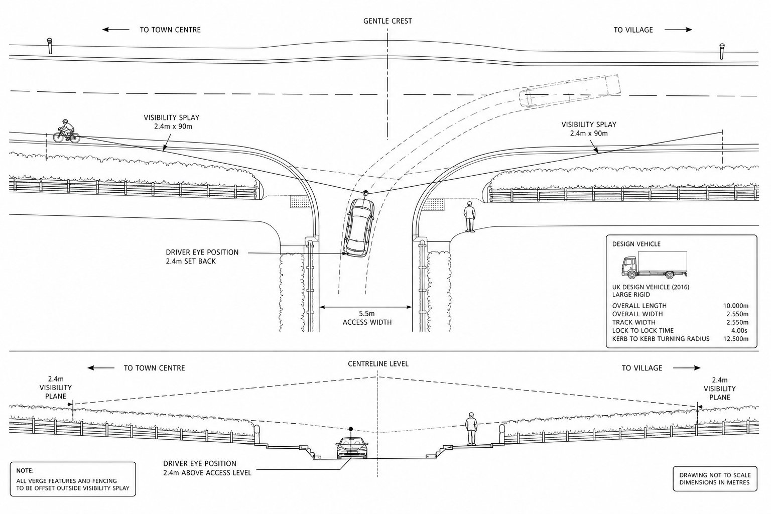
Horizontal and vertical alignment matter early. Hidden accesses on bends or crests raise obvious safety concerns because they shorten reaction time. Equally, an access with steep levels close to the carriageway can lead to vehicles grounding, dragging mud, or rolling slowly into the road while drivers hunt for visibility.
There is also the issue of consistency. A narrow urban frontage street can support a tighter, lower-speed design language than a fast rural road. Trying to import the geometry of one context into the other rarely ends well. On constrained sites, we often need to balance ideal standards with practical mitigation, but that only works if the departures are explicit and evidence-led.
For planning applications, the key is usually demonstrating that the geometry is not just technically possible but appropriate for day-one operation and future maintenance.
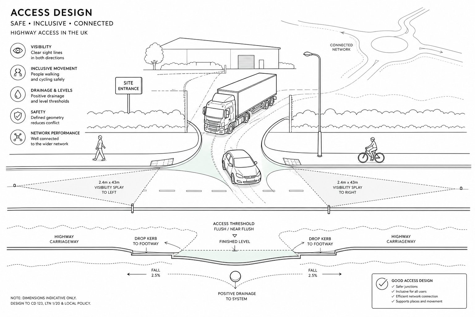
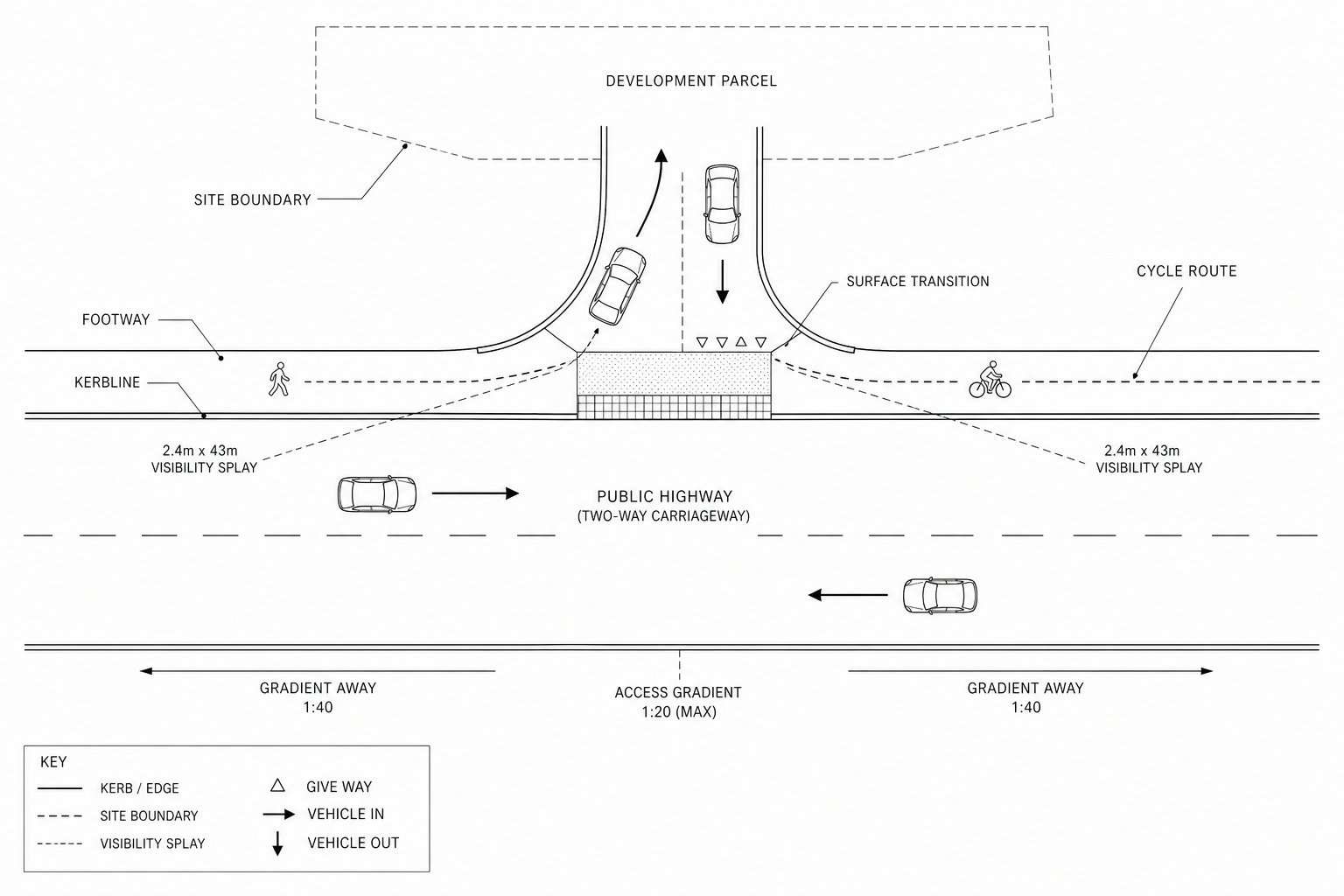
Visibility Requirements And How Splays Are Assessed
Visibility splays are one of the first things a highway officer will test because they directly affect driver decision-making. In simple terms, the splay is measured from a driver’s eye position set back from the edge of carriageway at the access, looking along the main road to a distance linked to stopping sight distance and the relevant design speed.
That last point matters. Posted speed is not always the same as observed speed. On some roads, authorities may look at actual 85th percentile speeds, local conditions or their own adopted visibility tables rather than the sign alone. Obstructions within the splay, walls, fences, planting, parked vehicles, embankments, can render an otherwise sensible access unacceptable.
Control is just as important as geometry. If the splay passes over third-party land and there is no legal means to keep it clear, planners may be reluctant to rely on it. We have seen technically sound access proposals delayed simply because the applicant could not demonstrate long-term control of frontage vegetation.
Visibility also has to work in three dimensions. Vertical curvature, hedge growth, street furniture and boundary returns can all interrupt sight lines in ways a flat site plan hides rather well.
Junction Form, Radii, Widths And Tracking For Different Users
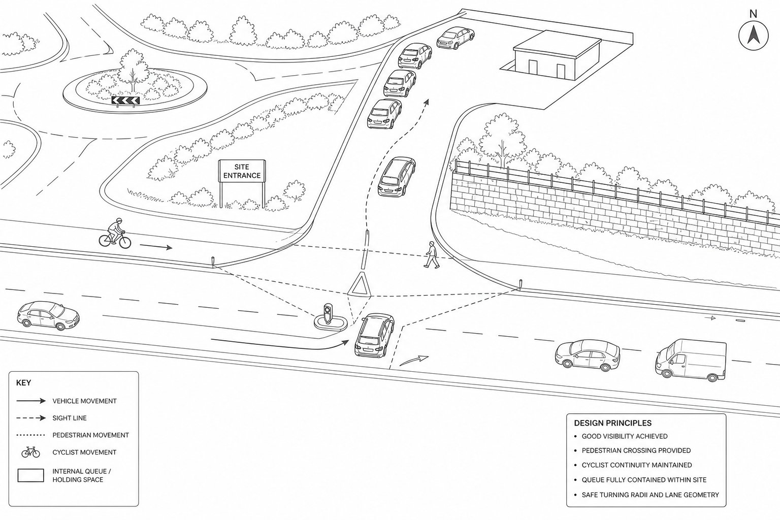
Once visibility is acceptable, the next question is whether the access form suits the turning task. Low-use residential accesses may need little more than a modest dropped kerb arrangement or simple priority junction. But where flows rise, or where larger vehicles need to turn without crossing opposing lanes awkwardly, entry widths and radii become critical.
Swept-path analysis is usually the decisive tool here. It tests whether the chosen vehicle can enter, exit and circulate without mounting footways excessively, striking boundary features or blocking opposing traffic. Refuse vehicles and articulated lorries are common governing vehicles because they reveal problems quickly.
The geometry should also account for the users not in cars. Large radii can encourage high-speed turning, which is poor news for pedestrians crossing the side road mouth. Sometimes the better answer is a tighter pedestrian-friendly corner with local widening, overrun strips or internal tracking space rather than a wide, highway-dominant bell-mouth.
Where schemes are more demanding, Junction Design Consultants: input can help reconcile competing needs: HGV access, pedestrian safety, frontage constraints and adoption expectations, all on one drawing, somehow.
Pedestrian, Cycle And Inclusive Access Considerations
A highway access is not just for drivers, even when the development itself is vehicle-led. The frontage often sits within an existing walking and cycling route, and planning authorities are now far less willing to approve layouts that treat those movements as an afterthought.
For pedestrians, continuity matters. Footways should remain legible and as level as possible across private accesses. Dropped kerbs, tactile paving and crossing design need to reflect likely pedestrian desire lines, not merely minimum drafting conventions. Fast, sweeping turning paths can make even a low-flow access feel uncomfortable, particularly for children, older people and mobility-impaired users.
Cyclists raise a similar issue. On streets with cycle routes, designers need to consider whether vehicles turning into the site will cut across rider priority, whether visibility between drivers and cyclists is adequate, and whether the access width or radius encourages speed. In some contexts, protected crossings or priority treatments will be the right response.
Inclusive design is not a decorative add-on. Gradients, crossfalls, kerb upstands, waiting areas and route widths should support real-world use by wheelchair users, people with visual impairment and those moving with prams or assistance devices. Equality considerations sit behind that, but so does basic street usability.
For larger or more delivery-intensive schemes, Onsite Delivery Transport planning often needs to align gate locations, servicing movements and pedestrian access so that one does not undermine the other. If the only way a bin lorry enters is by dominating the footway every Tuesday morning, the design still needs work.
Drainage, Levels, Surfacing And Boundary Constraints
Some of the most frustrating access problems are not about capacity at all. They are about water, topography and edges. An access that works beautifully on a swept-path plan can still fail if surface water runs onto the public highway, if levels create unsafe gradients, or if the boundary treatment needed for security wipes out the visibility splay.
Drainage is a classic planning condition issue. Authorities generally want confidence that runoff will not discharge uncontrolled onto the carriageway and that ponding will not form at the channel or crossing point. That usually means careful falls, local collection features and a realistic understanding of how the access ties into the site-wide drainage strategy.
Levels matter both operationally and structurally. Too steep near the highway and vehicles may scrape, hesitate or lose control in poor weather. Too flat, and drainage becomes difficult. Heavy vehicle access also requires adequate pavement construction, otherwise rutting and edge failure can appear surprisingly quickly.
Surfacing choice has a practical effect too. Bound gravel near the carriageway is one thing: loose material migrating into the highway is another. Permeable options can help, but only where the sub-base, contamination constraints and maintenance plan support them.
Then there are boundary constraints: retaining walls, utility apparatus, trees, hedges, easements and neighbouring ownership. These are the details that often turn a theoretical layout into a negotiated one. In broader highway infrastructure design, these edge conditions are often what determine whether an access is merely acceptable or genuinely deliverable.
When A Simple Access Becomes A Junction Design Issue
There is a point at which a “simple access” stops being simple. Usually, that happens when traffic volumes, turning patterns, speed environment or safety history indicate that a basic priority arrangement would no longer operate or perform adequately.
The triggers vary. A residential site of a few dwellings may function perfectly well with a straightforward minor arm. Increase the scale to dozens of units on a busier road, and the authority may expect a ghost island right-turn lane or a compact roundabout. On commercial sites, concentrated peaks, delivery activity and right-turn demand can escalate the issue even faster.
Context matters just as much as flow. If the access sits close to another junction, opposite an existing side road, near a school crossing, or on a route with a poor collision record, a seemingly minor proposal may need to be tested as part of a wider junction system. In urban areas, multiple direct accesses may be resisted in favour of a single consolidated side road under access management principles.
This is where modelling and option appraisal become useful rather than bureaucratic. We may need to compare a simple priority layout against a channelised form, signals or a roundabout, not because every scheme needs a major junction, but because planning decisions are easier to defend when alternatives have been examined properly.
That wider perspective sits at the heart of access design highway engineering: the access is judged not only by its kerbs, but by how it changes the behaviour and performance of the road around it.
Common Planning And Technical Issues That Delay Access Approval
Most delayed access approvals are not caused by exotic engineering problems. They usually come from ordinary issues identified too late.
Inadequate visibility is probably the most common. Either the measured splay does not meet the authority’s requirement, or the applicant cannot prove it will remain clear because part of it lies outside their control. The drawing may be correct, but if the hedge is on somebody else’s land, the objection writes itself.
Trip generation is another regular weak spot. When forecast traffic is understated, the chosen junction form can look artificially comfortable. Once the authority tests assumptions against TRICS data, local surveys or committed development, queueing and turn lane needs may reappear very quickly.
Spacing and standards also catch people out. An access too close to a roundabout, bus stop, crossing, bend or another junction may conflict with local guidance even if the geometry itself is tidy. Gradients, gate setbacks, refuse tracking and pedestrian continuity are similarly common points of challenge.
Drainage and buildability come later but can be just as damaging. If the levels do not work, or if utilities, trees or retaining requirements have been ignored, officers may doubt whether the approved drawing can ever be delivered on site.
In our experience, early coordination between architects, civil engineers and Highway Engineering Consultants prevents a lot of this. Not all of it, admittedly. But enough to save months rather than days.
What A Transport Consultant Will Usually Assess And Submit
For a planning application, a transport consultant’s role is usually to turn a proposed point of access into an evidence-backed package the authority can review with confidence. The exact scope depends on development scale, road type and local validation requirements, but the core submissions are fairly consistent.
First comes the access strategy itself: where the access should be, how many access points are justified, and what junction form is likely to be acceptable. That may include an option appraisal if more than one layout is plausible.
Traffic evidence then follows. Depending on the scheme, this can include traffic counts, speed surveys, trip generation, modal assumptions, distribution and assignment, and an assessment of likely turning movements. If network effects may be material, capacity modelling and queue analysis for the proposed access and nearby junctions are commonly required.
Design submissions typically include general arrangement drawings, visibility splay plans, longitudinal sections showing gradients, and swept-path analysis for the design vehicle. Supporting civil input may cover drainage principles, levels and construction assumptions. On sensitive schemes, Stage 1 Road Safety Audit input is often expected, whether formally submitted or discussed during design development.
The reporting package usually sits within a Transport Statement or Transport Assessment, with coordinated wording in the Design and Access Statement. On more complex applications, Highway Engineering Consultants For planning work are often as valuable for resolving authority queries and refining the design as they are for preparing the first set of drawings.
Conclusion
Access design in highway engineering is where planning ambition meets highway reality. A credible proposal has to do more than fit a red line boundary: it must respect road function, provide suitable visibility, accommodate the right vehicles, support walking and cycling, manage drainage and levels, and avoid creating operational problems beyond the site frontage.
For planning applications in 2026, that means the strongest access strategies are usually the ones developed early, tested properly and aligned with both national guidance and local authority expectations. Small details matter because they are often what determine whether a layout is simply attractive on paper or genuinely capable of approval and delivery.
When we approach access design well, we reduce risk in three directions at once: planning risk, safety risk and delivery risk. And that is exactly why it remains one of the most important pieces of transport engineering input on any development scheme.
Frequently Asked Questions about Access Design in Highway Engineering
What is access design in highway engineering?
Access design in highway engineering involves planning how vehicles, pedestrians, and cyclists safely enter and exit a site from the public highway while maintaining road function and safety. It addresses access points such as driveways, junctions, and private roads in line with the road hierarchy.
Why does good access design matter for planning approval?
Good access design demonstrates that development traffic can enter and leave safely without causing unacceptable impacts on highway safety or operational capacity. It helps secure planning approval by aligning with local policies and reducing risks related to collisions and traffic disruption.
How do vehicle type and traffic demand influence access design?
The design vehicle size and type, such as cars, refuse vehicles, or articulated lorries, determine entry widths, radii, and internal turning requirements. Traffic demand and turning movements drive the need for features like right-turn lanes, signals, or roundabouts to maintain safe and efficient operation.
What are the key geometric principles for safe highway access?
Safe access design ensures drivers have adequate visibility, predictability in slowing and turning, and alignment consistent with road speed and function. This includes appropriate horizontal and vertical alignment, clear sight lines, and avoiding hidden or steep accesses to reduce conflict and collisions.
How is visibility assessed in access design and why is it important?
Visibility splays are measured from a driver’s eye position to a stopping sight distance along the main road, considering actual speeds. Clear visibility is critical for safe vehicle manoeuvres, and obstructions or lack of control over vegetation in the splays can delay or prevent planning approval.
When does a simple access become a junction design issue?
A simple access escalates to a junction design when traffic volumes, turning patterns, or safety concerns require channelised lanes, signals, or roundabouts. Also, consolidation of multiple accesses into one or proximity to other junctions may necessitate more complex junction design solutions.