If you are promoting a site in Norbury, transport is rarely a side note. It often becomes one of the questions that decides whether an application moves forward smoothly, stalls in consultation, or comes back with awkward requests for more evidence. The reason is simple enough: Norbury sits on a busy part of south London, with the A23 corridor, dense residential streets, frequent bus movement, rail access, parking pressure, school traffic, and junctions that can feel stretched before a new scheme even appears on paper.
That is where a traffic engineer in Norbury adds real value. We do not just produce a report to satisfy a planning checklist. We help show, in technical and practical terms, that development can be accommodated safely, efficiently, and in a way that aligns with local and national transport policy. For architects, planners, solicitors, surveyors, developers, and local authorities, that usually means proportionate evidence, local judgement, and clear responses to likely objections.
In practice, the strongest planning submissions are rarely the longest. They are the ones built on the right scope, reliable survey data, defensible trip assumptions, and a proper understanding of how Croydon and highway consultees are likely to review the scheme. In this guide, we set out what a Norbury traffic engineering study typically involves, when a Transport Assessment or Transport Statement is needed, and how to reduce delay while improving the chances of approval in 2026.
Key Takeaways
- A traffic engineer in Norbury plays a crucial role in ensuring development proposals are safely and efficiently integrated with the busy local transport network, especially along the A23 corridor.
- Transport Assessments or Statements are required based on the scale and transport impact of a development, with local context in Norbury influencing the level of detail needed.
- Effective traffic engineering studies include baseline data, trip generation analysis, swept path assessments, and parking and cycle provision reviews tailored to Norbury’s unique constraints.
- Early collaboration between traffic engineers, architects, planners, and developers helps identify and resolve transport issues before submission, speeding up approvals.
- Local councils expect clear, up-to-date, and proportionate transport evidence, including justification for parking, access design, and junction impact, to reduce objections and delays.
- Choosing a traffic engineer familiar with Norbury’s local conditions and London’s planning policies leads to concise, defensible reports that facilitate smoother planning application processes.
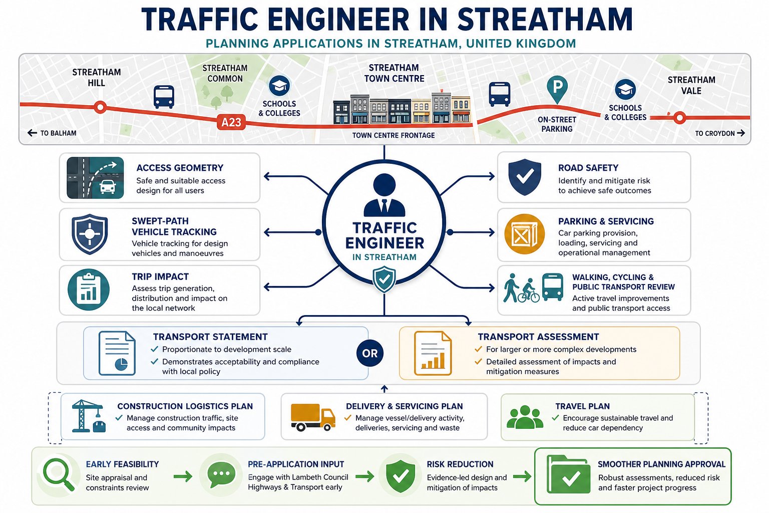
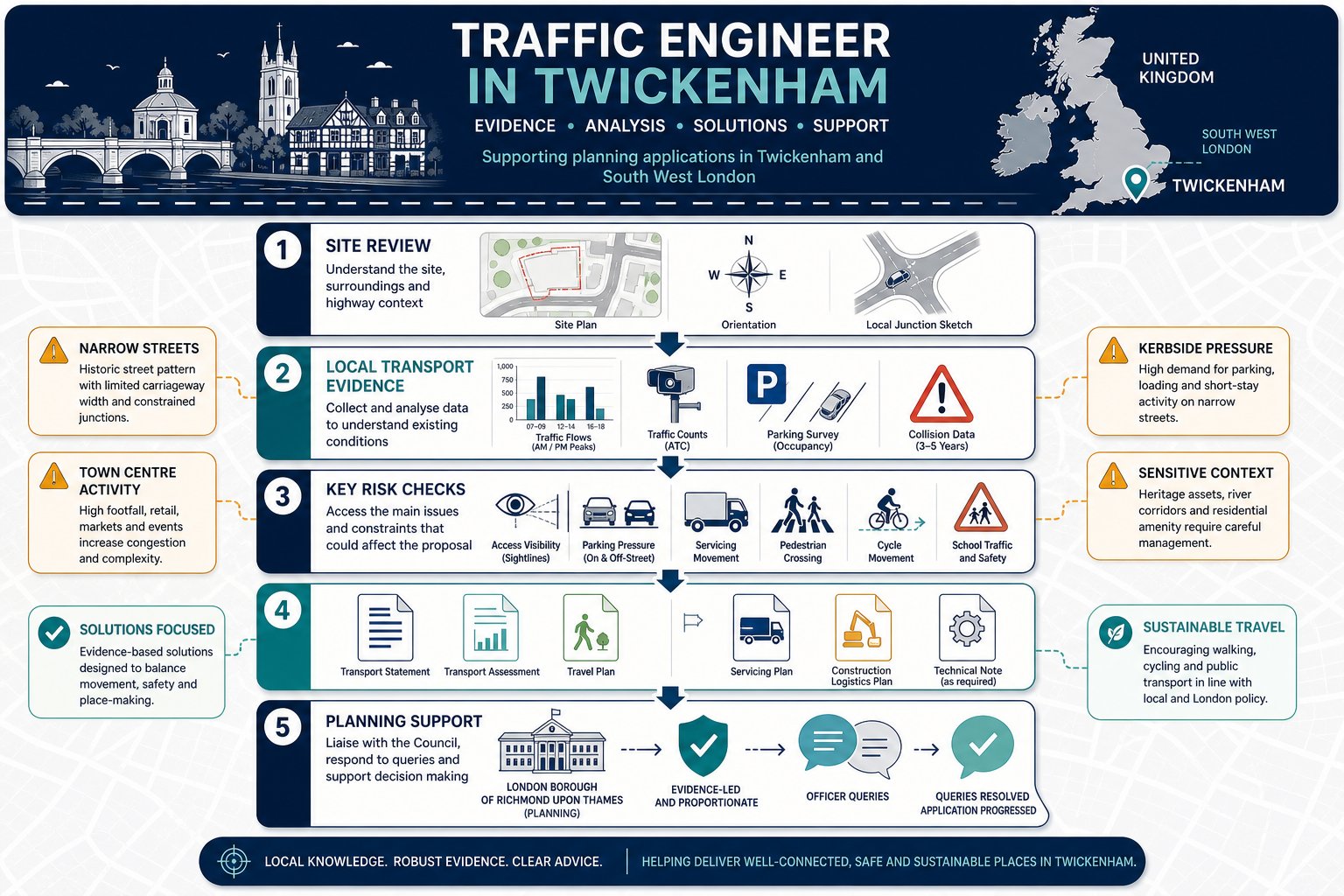
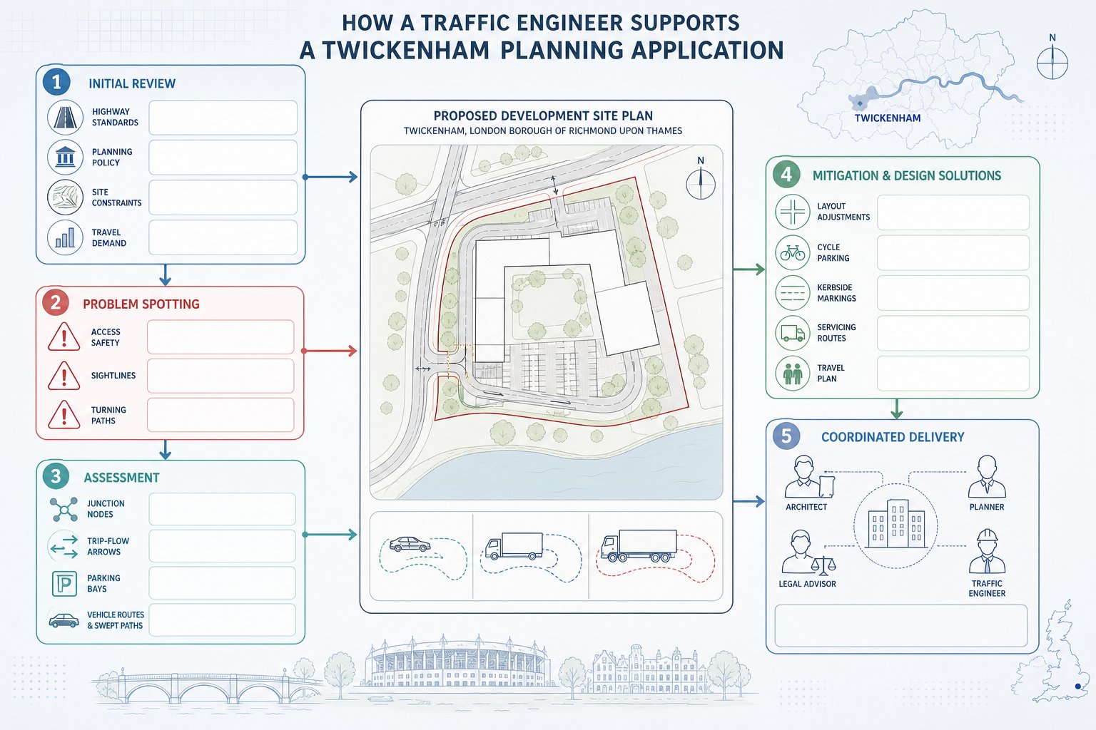
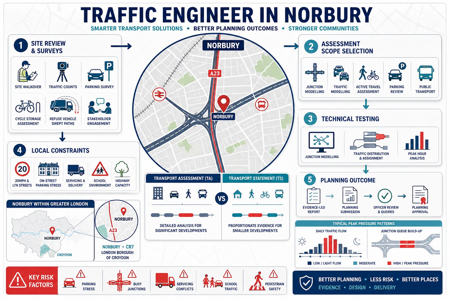
What A Traffic Engineer In Norbury Does For Planning Applications
A traffic engineer in Norbury supports planning by testing whether a development works in transport terms before the application is exposed to scrutiny. That sounds straightforward, but the job usually spans far more than writing a Transport Statement.
We review existing access conditions, likely trip generation, servicing needs, parking demand, cycle provision, pedestrian links, visibility, and the effect of the scheme on nearby junctions. We also help project teams decide what level of reporting is proportionate. A small infill scheme may need a concise note and swept paths: a larger mixed-use or care-led proposal may require a full TA, Travel Plan, collision review, and capacity modelling.
The practical value is often in identifying risk early. If refuse vehicles cannot enter and leave in forward gear, if the parking layout conflicts with London standards, or if a proposed access sits too close to a junction, it is far better to address that before submission. That is why early planning support from Traffic Engineering Consultants: tends to save time later.
In London borough contexts, the engineering case also needs to mesh with planning strategy. Our role is technical, yes, but it is also about judgement: what will the council accept, what can be justified, and what needs redesign rather than clever wording.
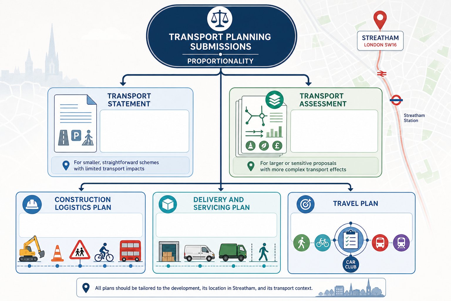
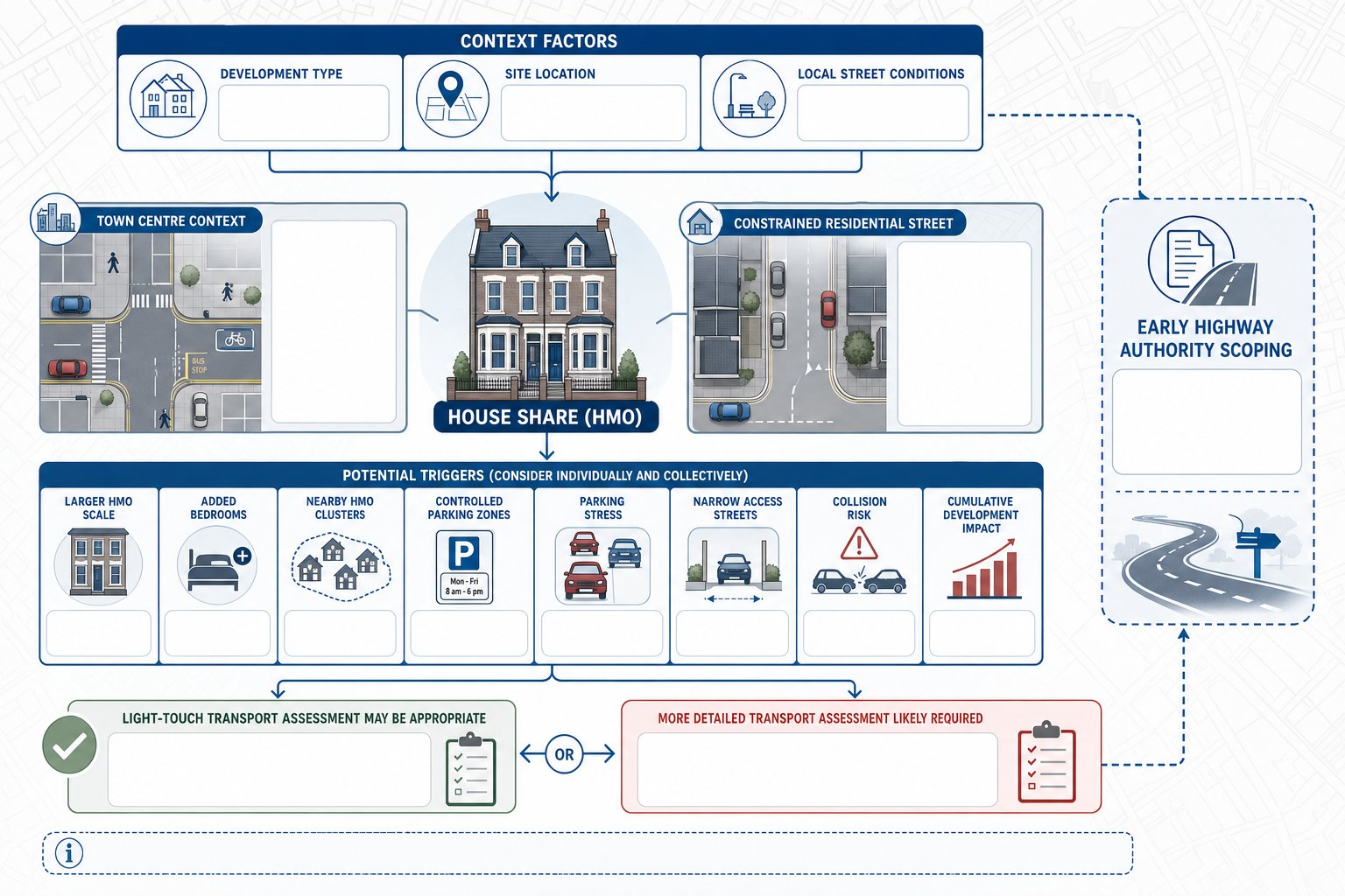
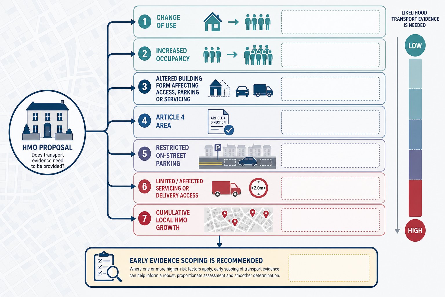
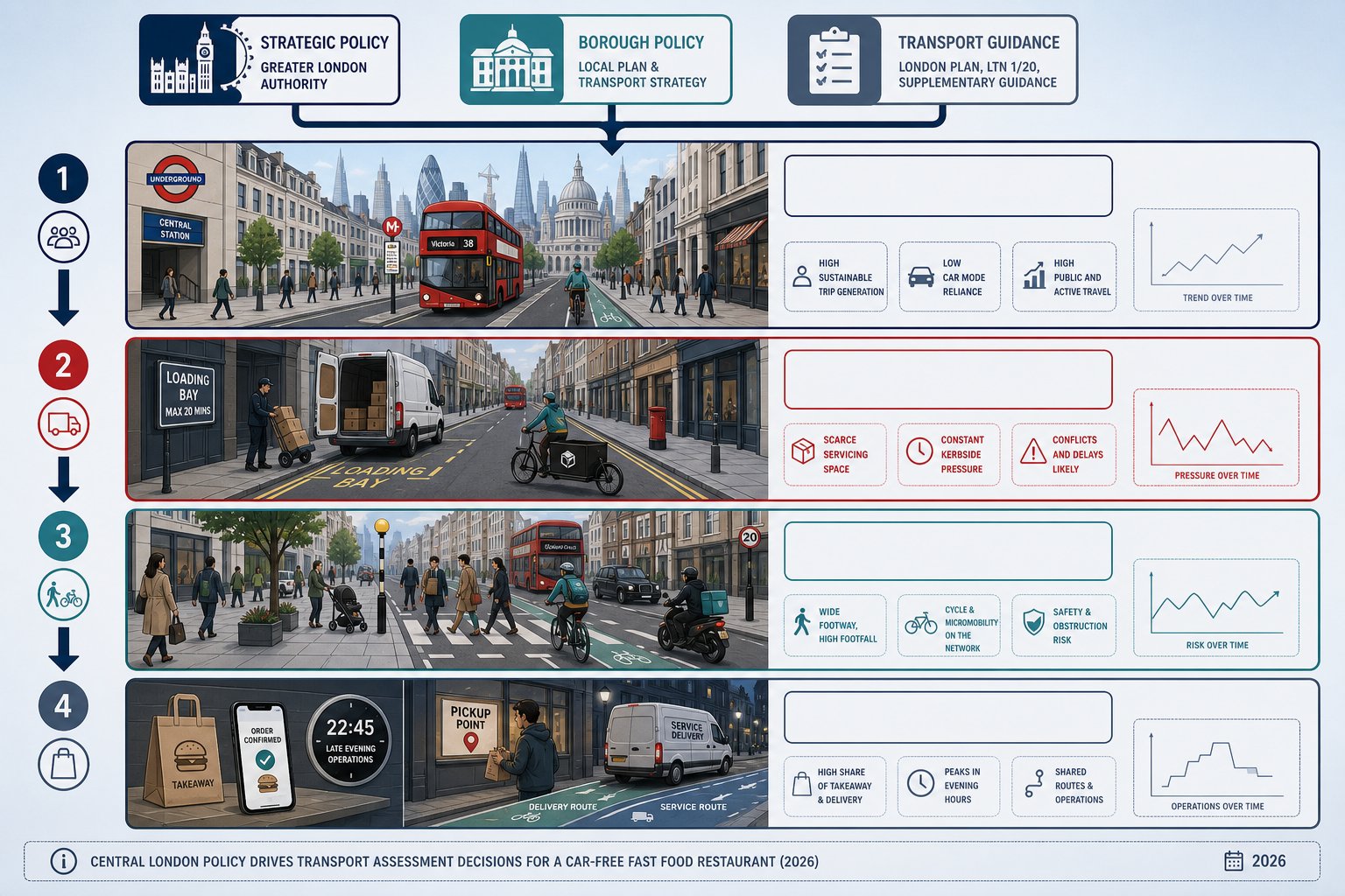
When A Transport Assessment Or Transport Statement Is Needed
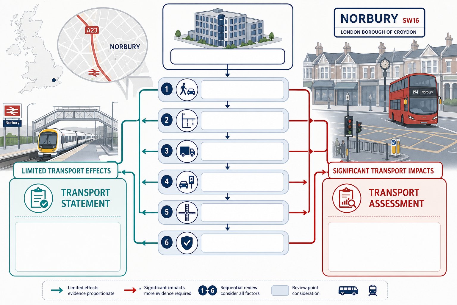
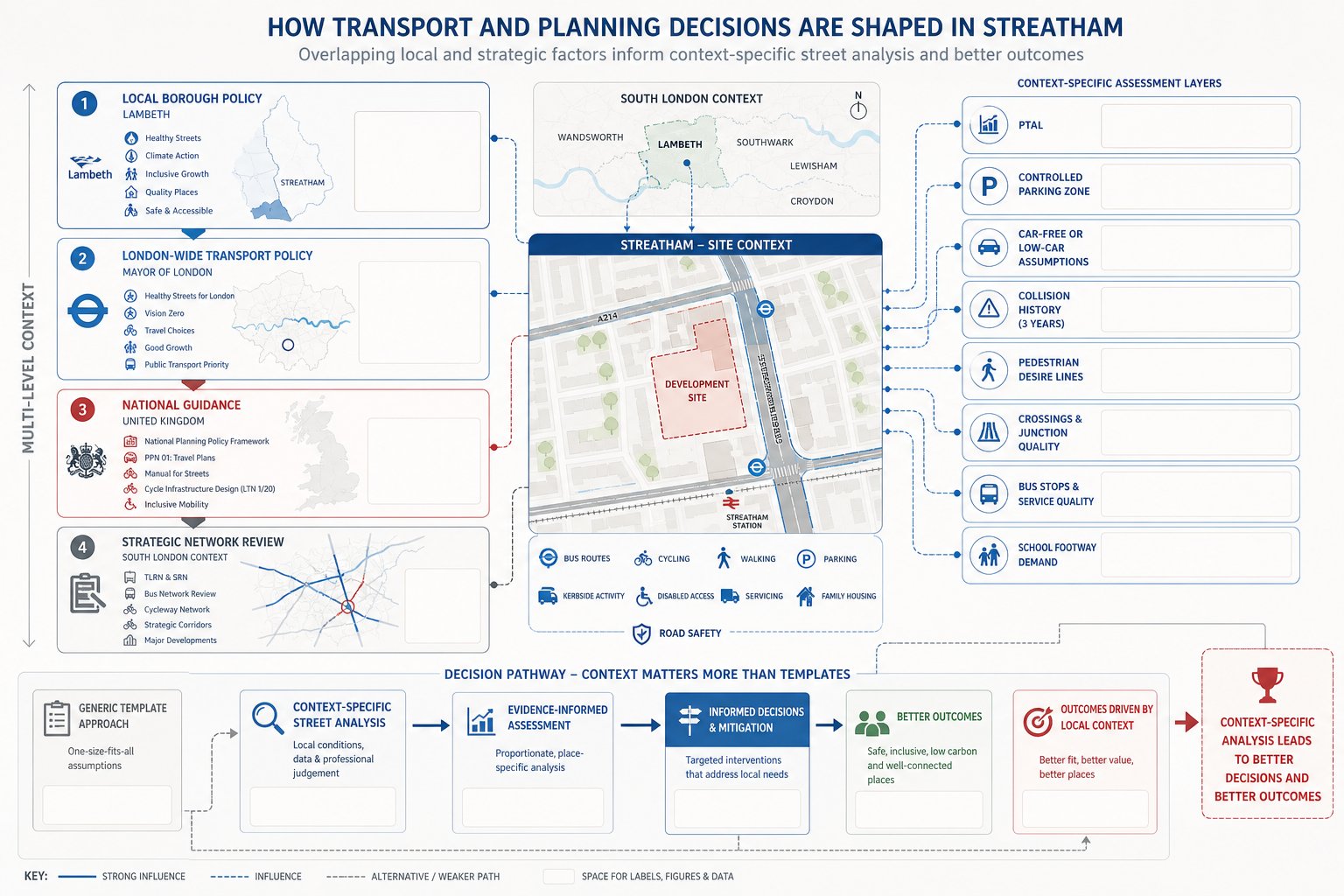
The answer depends on scale, land use, and likely transport effect. Under UK planning practice, a Transport Assessment is generally expected where development has significant transport implications. A Transport Statement is the lighter-touch option for schemes with more limited effects. The line between the two is not fixed nationally for every site, which is why local validation requirements and officer expectations matter so much.
In Norbury, the threshold question is not only about unit numbers or floorspace. It is also about context. A modest scheme on a quiet site with good public transport access may justify a short statement. The same quantum of development on a constrained frontage near a sensitive A23 junction or a heavily parked residential street may need fuller evidence.
We usually advise teams to decide this through a quick early review of:
- likely person trips and vehicle trips
- access complexity
- servicing arrangements
- local parking stress
- junction sensitivity in peak hours
- whether mitigation may be needed
For developers used to broader regional projects, London expectations can feel tighter. That is why a localised approach matters more than generic threshold tables. Work informed by Traffic Engineer In London: usually performs better because it reflects borough-specific scrutiny, not just textbook guidance.
And one practical point: if there is any doubt, agreeing scope early with the council or highway authority is nearly always cheaper than defending the wrong document after submission.
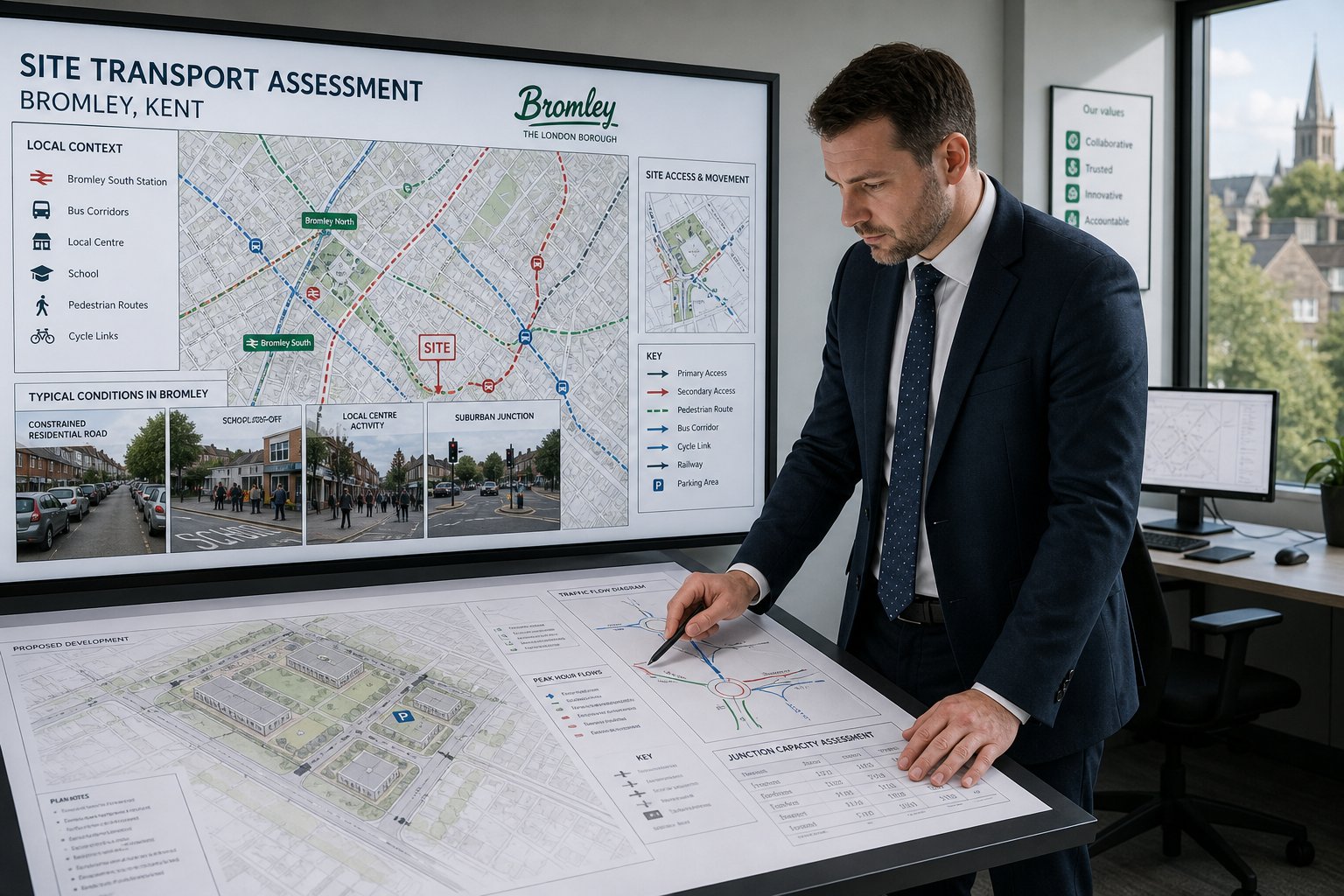
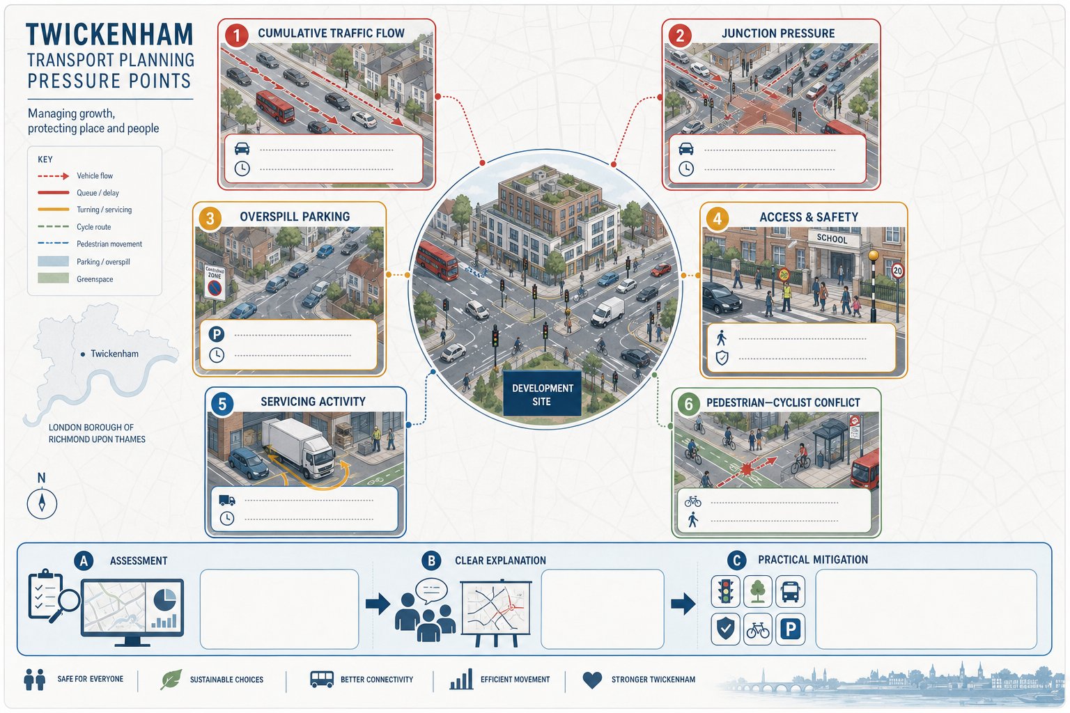
How Norbury’s Road Network And Local Constraints Shape Development
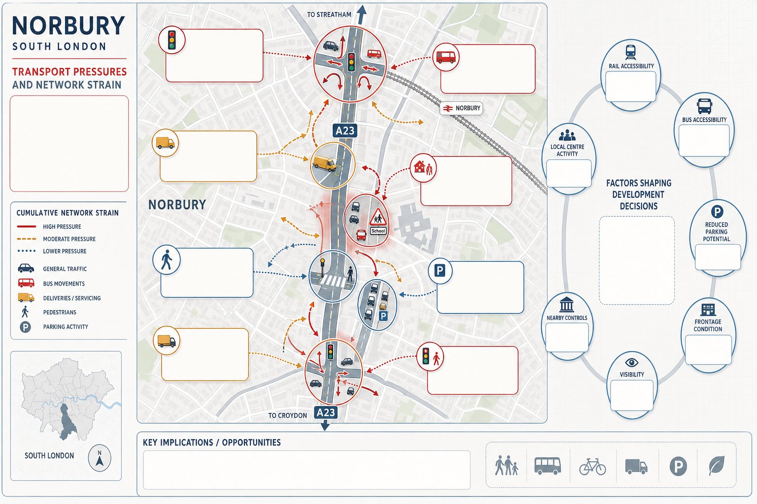
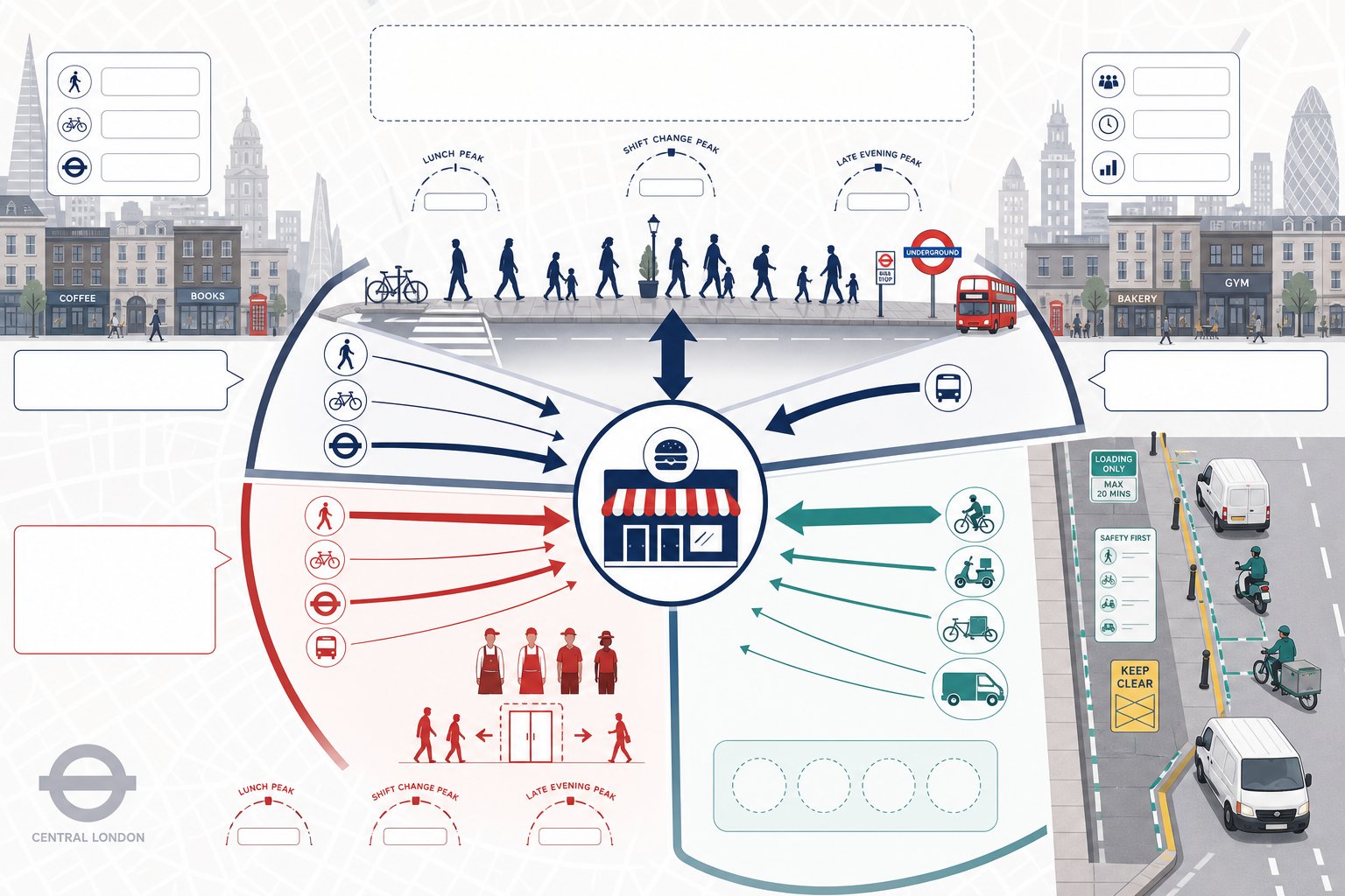
Norbury is shaped by movement corridors that are useful, busy, and sometimes unforgiving. The A23 is the obvious spine. It carries through traffic, buses, turning movements, delivery activity, and the kind of peak-period pressure that can make even small additional delays feel visible. For planning purposes, that means impact is not measured in a vacuum. It is measured against a network already working hard.
Side streets add another layer. Many are residential, narrow in feel, and sensitive to overspill parking, awkward servicing, and increased turning at junction mouths. Where schools, parades, community uses, or local centres sit nearby, the day is not defined by one simple traffic peak. There may be school arrival activity, bus stop interaction, informal loading, and pedestrian crossings that affect how access performs in reality.
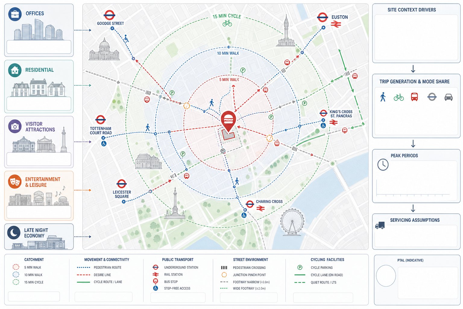
Public transport is an asset, of course. Rail and bus accessibility can support lower car trip assumptions and reduced parking in suitable cases. But that argument only succeeds when it is evidenced properly and linked to the actual site catchment, not asserted as a London-wide generality.
This is where broader Traffic Engineering and principles need translating into local decision-making. In Norbury, layout, frontage condition, visibility, nearby controls, bus activity, and parking demand all influence what is realistic. A technically compliant design that ignores those local frictions often draws objections anyway.
Key Planning And Highway Issues That Commonly Affect Norbury Sites
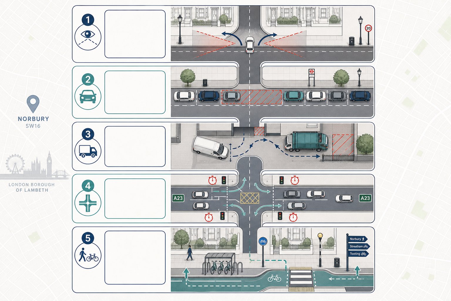
Certain issues appear again and again on Norbury schemes, regardless of whether the project is residential, commercial, education, healthcare, or mixed use.
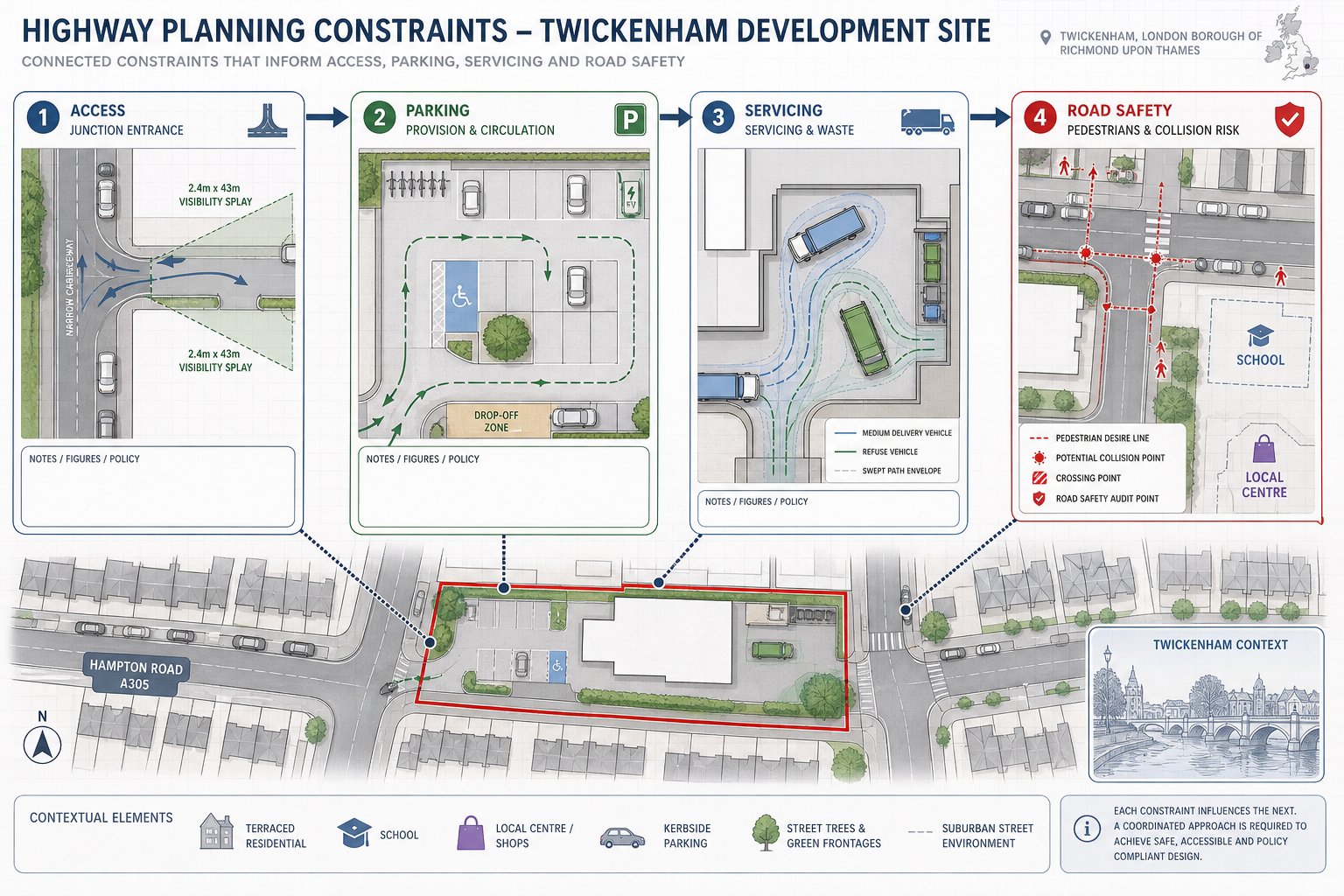
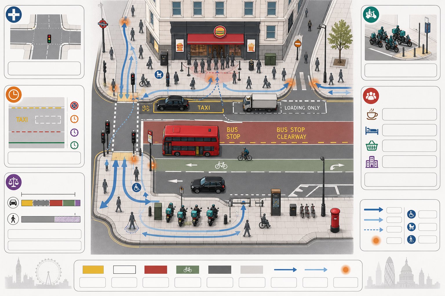
First, safe and acceptable access. Highway officers will look closely at geometry, forward visibility, pedestrian interaction, proximity to junctions, and whether vehicles can enter and leave without unsafe manoeuvres. A simple access can become contentious if the frontage is constrained.
Second, parking stress. In streets where demand is already high, councils will test whether on-site provision is policy-compliant and whether reduced provision is genuinely justified by PTAL, local character, and likely occupancy. Unsupported assumptions about car ownership do not usually travel well.
Third, servicing and deliveries. This is a frequent problem on tighter plots. If a van, refuse vehicle, or occasional larger delivery cannot operate safely, the issue quickly spreads into obstruction, reversing, and amenity concerns.
Fourth, junction impact. Schemes that add only modest vehicle numbers can still trigger scrutiny if traffic routes pass through sensitive A23 junctions or if right-turn movements create delay.
Finally, walking and cycling. London planning policy expects more than a token cycle store. Officers want to know whether the provision is accessible, secure, and integrated with the layout.
A grounded understanding of Highway And Traffic issues helps frame these points clearly, so the report addresses likely consultee concerns before they are raised.
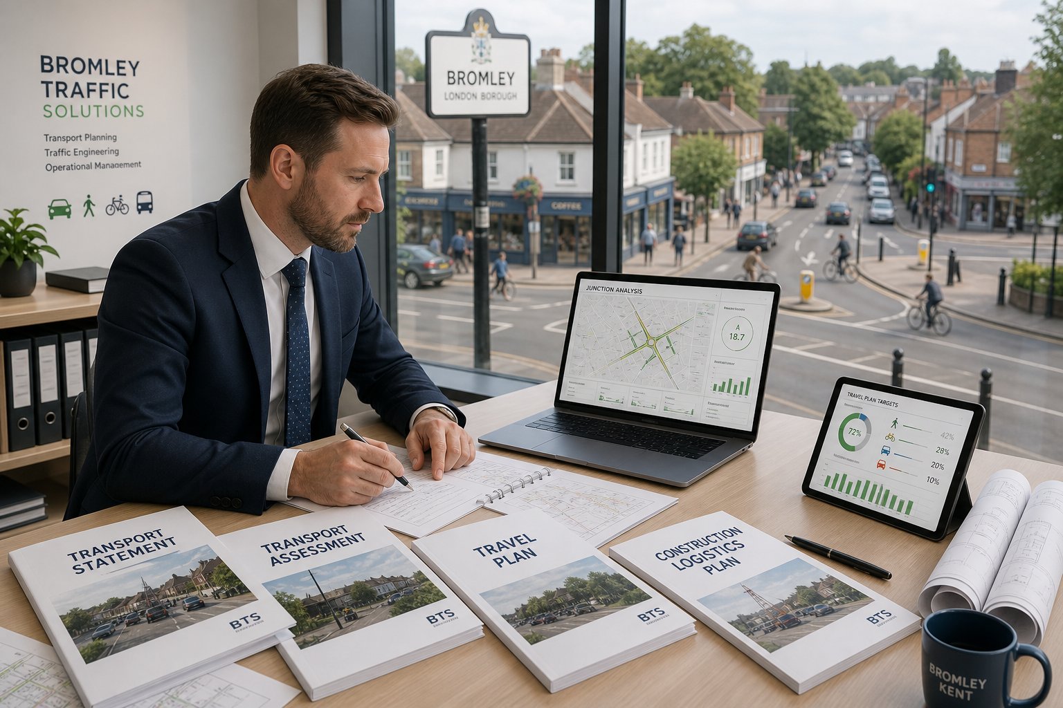
Transport Assessments, Travel Plans, And Technical Notes Explained
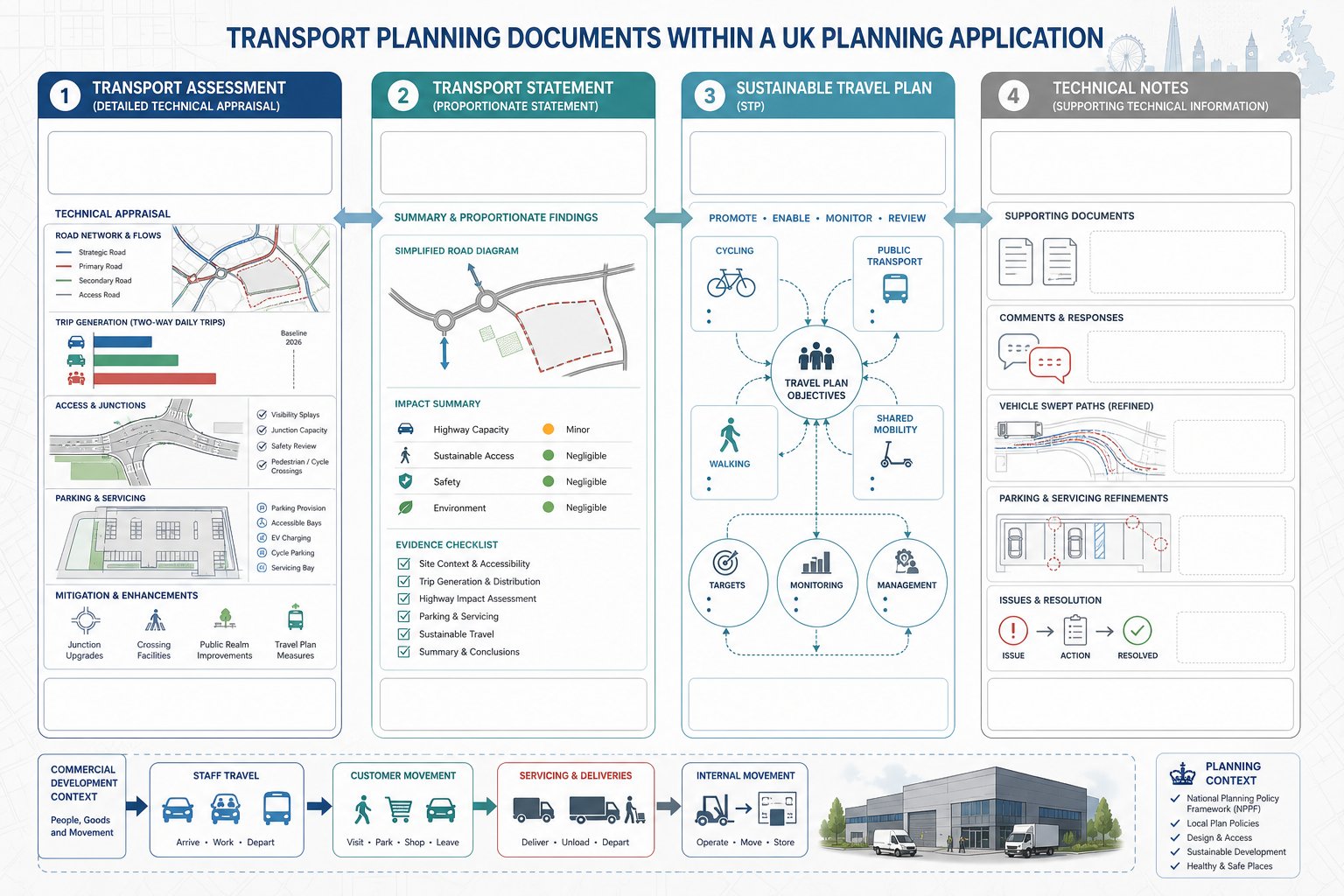
These documents do different jobs, even though they are often bundled together in planning conversations.
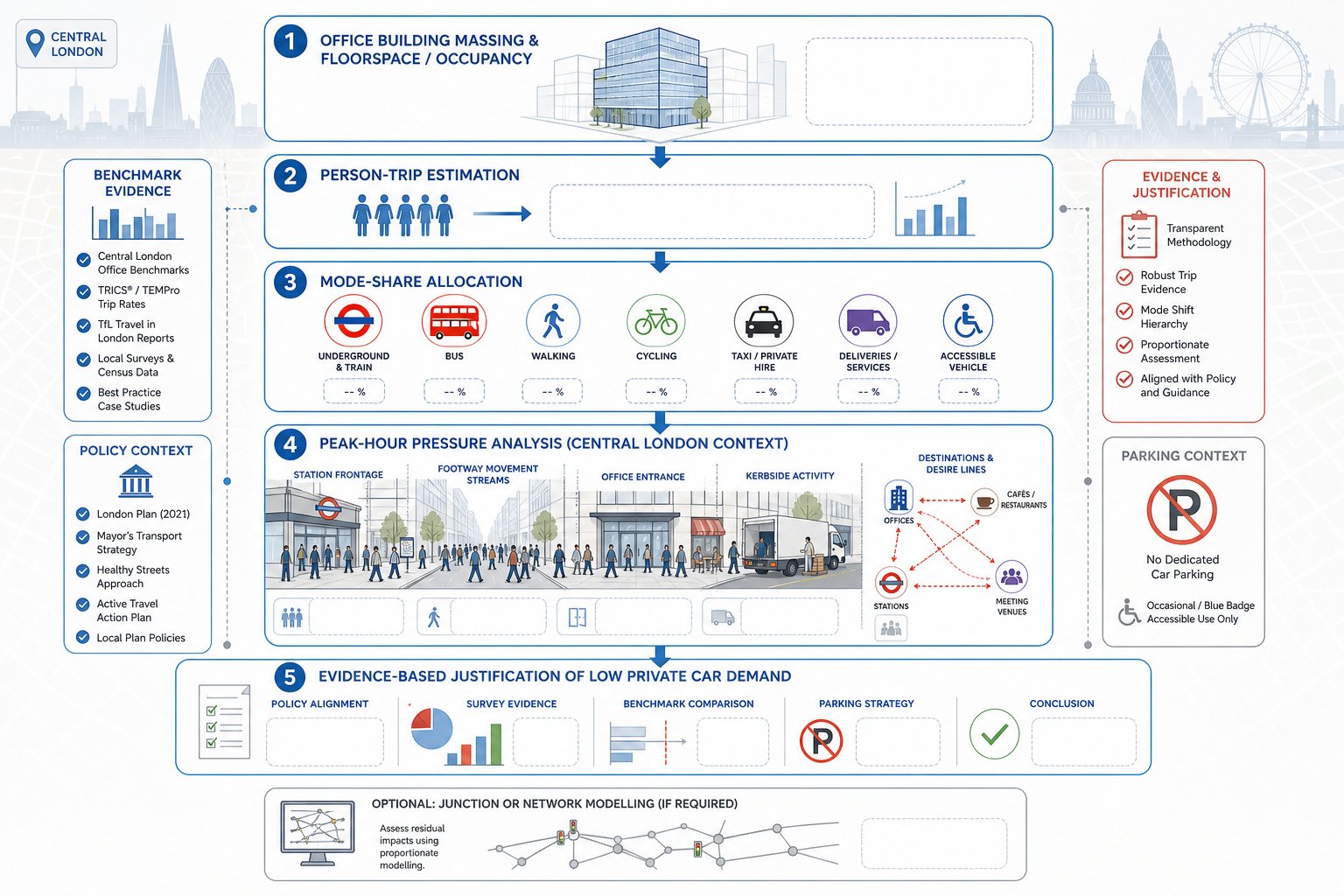
A Transport Assessment is the full technical appraisal. It explains baseline conditions, the development proposals, person trip and vehicle trip generation, mode share, distribution and assignment, parking and servicing, access design, and the effect on the surrounding network. If required, it also covers junction modelling and mitigation.
A Transport Statement is shorter and proportionate. It is suitable where impacts are limited and complex modelling is not justified. But “short” does not mean casual. It still needs evidence, clear assumptions, and proper policy alignment.
A Travel Plan focuses on sustainable travel measures. Depending on the scheme, this may be framework or full. It typically includes targets, monitoring, management arrangements, cycle support, public transport information, and measures to reduce single-occupancy car travel.
Then there are technical notes. These are often the unsung documents that keep an application moving. We use them to respond to consultee comments, explain survey updates, refine parking justification, submit revised swept paths, or address objections on specific points. On complex projects, they can be as important strategically as the main report.
For developer-led schemes, the distinction is especially important in Commercial Traffic Engineering work, where servicing, staff travel, customer turnover, and delivery patterns often need a sharper level of explanation than a standard housing scheme.
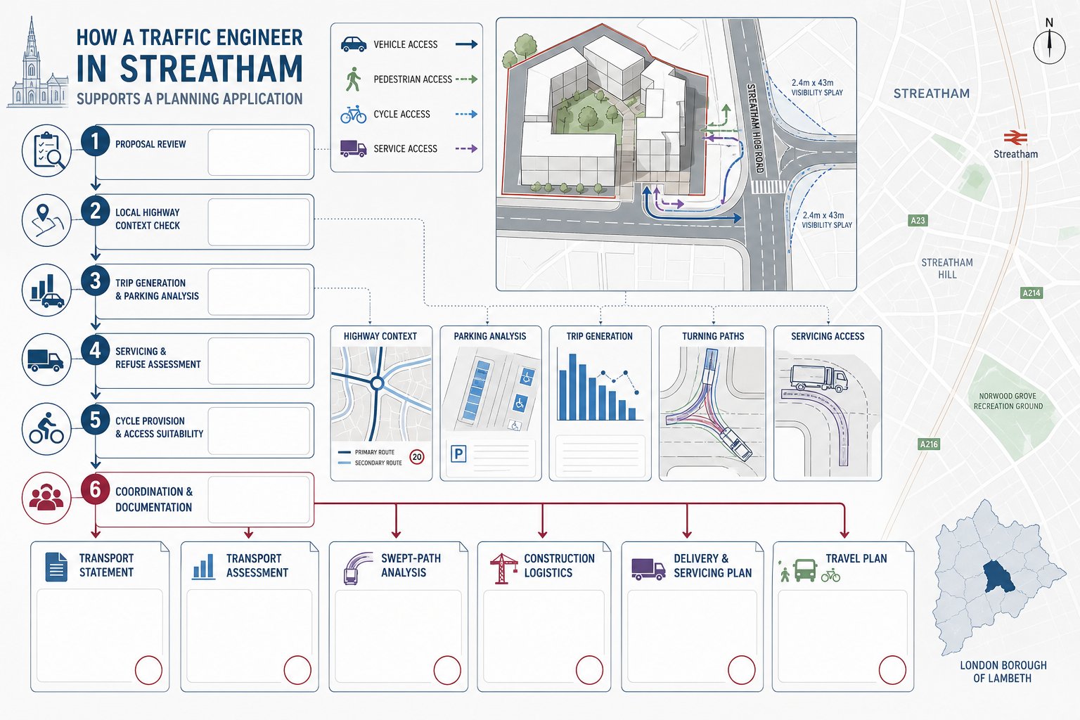
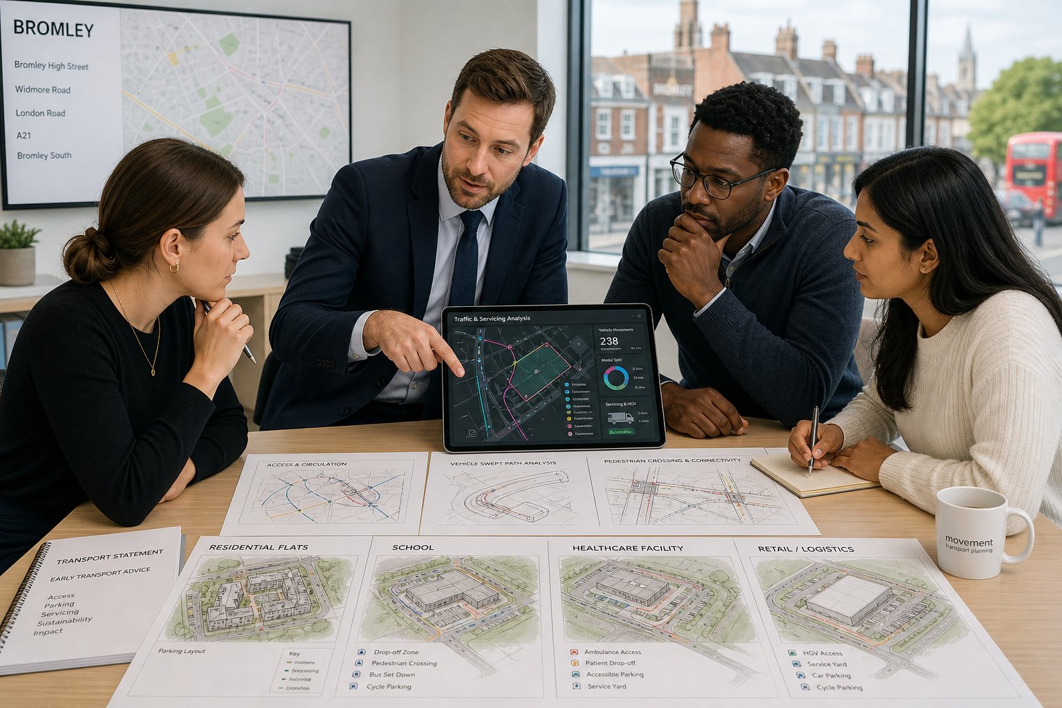
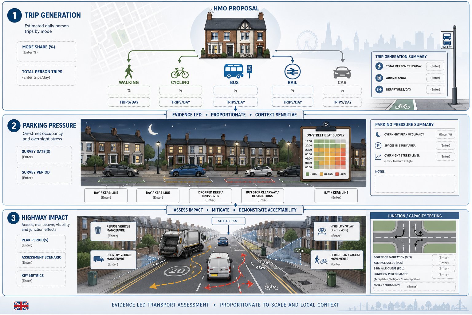
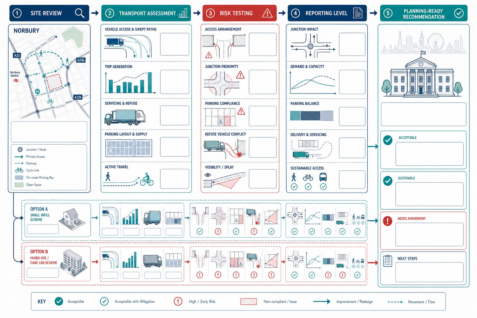
Scope Of Work Typically Included In A Norbury Traffic Engineering Study
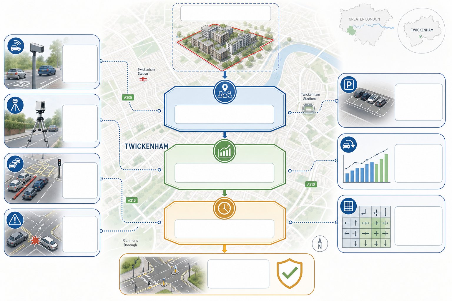
A Norbury study usually starts with proportionality and ends with evidence that a planning officer and highway consultee can actually use. The exact scope varies, but most projects include baseline review, site observations, policy context, survey analysis, trip generation, access and servicing assessment, parking review, cycle provision, and where needed, capacity testing.
Baseline work often covers traffic counts, queue observations, speed data where relevant, collision history, parking surveys, and a desk-based review of nearby controls and constraints. We then combine that with TRICS, Census and local travel characteristics to establish realistic trip rates and mode shares.
For many projects, the report also needs to explain why a simpler approach is sufficient. Not every scheme needs extensive modelling. But every scheme does need a transparent method, current evidence, and reasoning that reflects local conditions rather than boilerplate.
That broader discipline sits within Traffic Engineering: Your day-to-day planning practice: being clear on what to test, what to leave out, and how to present findings without creating avoidable debate.
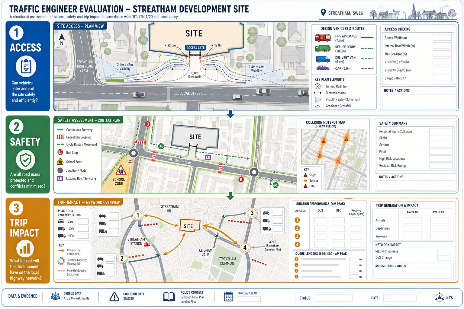
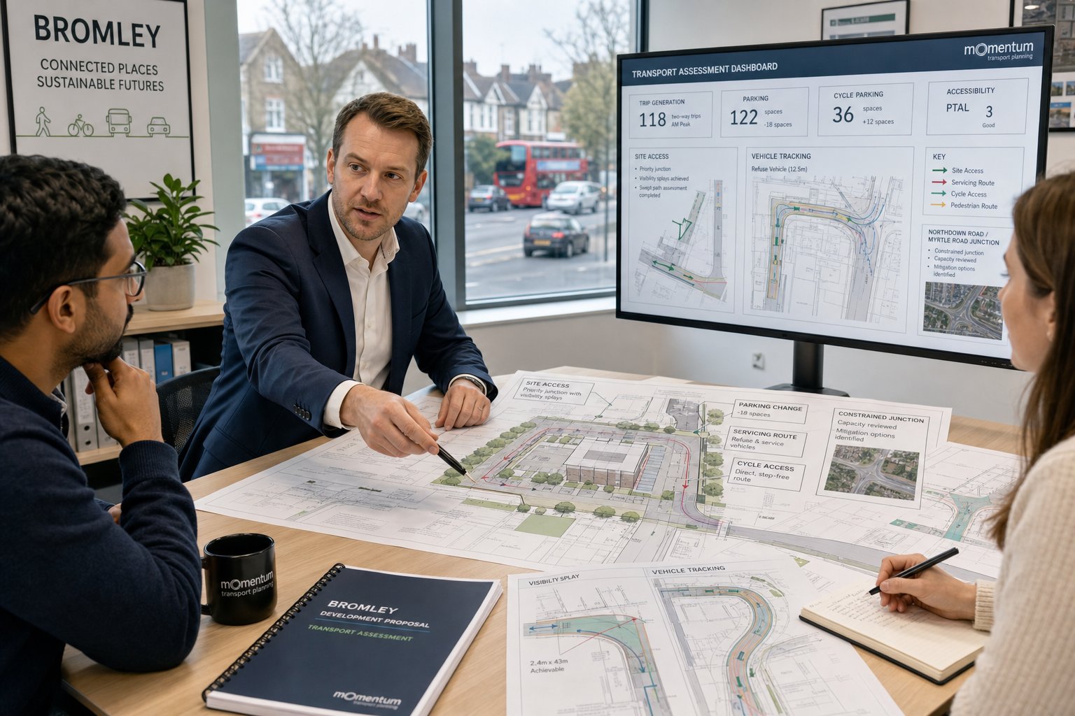
Vehicle Access, Servicing, And Swept Path Analysis
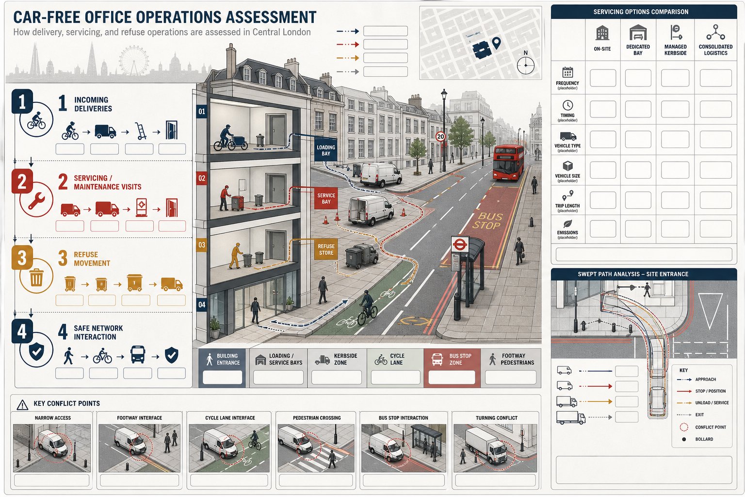
Access and servicing are usually where layout ambition meets highway reality. We test whether the proposed access width, radii, alignment, gradient, and visibility are suitable for the vehicles expected to use the site. That can include private cars, refuse vehicles, delivery vans, maintenance vehicles, and emergency access where required.
Swept path analysis is central here. Using vehicle tracking software such as AutoTrack, we check whether vehicles can manoeuvre without overrunning footways, striking street furniture, or relying on unrealistic driver behaviour. For Norbury sites, the most common pressure points are tight forecourts, awkward bin collection routes, and constrained exits onto busy roads where forward gear egress becomes non-negotiable.
A good swept path drawing does more than prove a turn. It ties into kerb design, gate positions, parking bay placement, landscape features, and servicing strategy. If those pieces are prepared separately, conflicts creep in fast.
We often find that a minor layout amendment early on avoids a much bigger planning problem later. Moving a bay, widening a throat, changing servicing frequency, or adjusting a refuse collection point can make the difference between an acceptable arrangement and one that attracts a holding objection.
Parking, Cycle Provision, And Trip Generation Review
Parking arguments in Norbury need care. London policy may support restrained car parking in accessible locations, but the council will still want to know whether the actual development is likely to function without creating overspill pressure. That means looking at land use, likely occupancy, surrounding parking conditions, permit controls, blue badge demand, visitor needs, and whether car-free or low-car assumptions are credible.
Cycle provision matters just as much now. Officers expect secure, convenient, policy-compliant spaces that people will genuinely use. A cycle store tucked behind several doors and a sharp turn is technically present, but functionally poor.
Trip generation review sits alongside both issues. We use TRICS, local census patterns, public transport accessibility, and site-specific characteristics to forecast demand in a defensible way. The judgement call is often in selecting the right comparator sites and then explaining why those rates fit Norbury rather than somewhere looser in suburban character.
Parking evidence informed by a robust parking strategy traffic approach is usually easier for officers to accept, because it connects policy standards with real operating conditions rather than treating parking as a simple numerical exercise.
How Junction Capacity And Traffic Impact Are Assessed
Traffic impact assessment usually begins with a simple question: will the development materially change how the surrounding network operates? To answer that properly, we need more than intuition.
We start with baseline traffic conditions using counts, queue observations, and site inspections. Then we estimate development traffic through trip generation and assign those trips across likely routes. If junctions are sensitive, we test them using recognised software such as PICADY for priority junctions, ARCADY for roundabouts, and LINSIG or SYNCHRO for signal-controlled layouts.
The output is not just a pile of ratios and delays. We interpret whether the change is material in planning terms, whether there is reserve capacity, and whether any increase is severe or manageable. On some Norbury sites, the answer is that the effect is negligible. On others, the issue is not overall volume but one turning movement in one peak hour.
Mitigation may include altered access geometry, servicing controls, travel plan measures, signal amendments, or off-site improvements. But mitigation needs to be proportionate. Over-engineering a small scheme can be as unhelpful as under-assessing a large one.
What matters most is that the analysis is current, transparent, and tied to the realities of the local network rather than generic assumptions.
Working With Architects, Planning Consultants, And Developers
The strongest transport work is collaborative. Rarely does a planning application succeed because one consultant produces a technically correct document in isolation. It works because the architect, planner, transport engineer, developer, and sometimes legal team resolve conflicts early enough to present a coherent scheme.
We often begin by reviewing a draft layout before the design is fixed. That lets us flag access issues, refuse tracking concerns, parking shortfalls, cycle store pinch points, and likely officer questions while changes are still easy. Once a scheme reaches detailed design, even a small transport-driven amendment can become awkward and expensive.
Planning consultants are equally important because transport evidence has to support the planning case, not sit beside it. If the design narrative says car-lite living but the parking survey suggests heavy on-street demand, the application needs a joined-up position.
For developers, speed matters. Concise reporting, clear assumptions, and an agreed scope can remove weeks of back-and-forth. In many cases, that is the difference between a smooth determination and a request for further information that drifts the programme.
That is also why specialist teams with local planning experience tend to outperform generic report writers. In practice, transport is often less about producing more pages and more about producing the right pages.
What Local Councils And Highway Authorities Expect To See
Councils and highway authorities are not looking for unnecessary complexity. They are looking for confidence. They want to see that the applicant understands the site, the likely impacts, and the standards by which the proposal should be judged.
In Norbury-related submissions, that usually means:
- up-to-date and relevant survey data
- clear site description and local context
- justified trip generation and mode share assumptions
- policy references that are current and locally relevant
- access drawings that align with the architect’s plans
- swept paths where servicing or constrained manoeuvring is an issue
- parking and cycle provision assessed against London and local standards
- junction analysis where network effects may be material
- Travel Plan measures where sustainable transport commitments are needed
They also expect consistency. If one drawing shows six spaces and the report assesses five, trust drops quickly. The same applies if the TA uses old surveys without explanation or if the servicing strategy is described vaguely.
Across London, officer expectations are shaped by practical planning experience as much as formal policy. Broader Traffic Engineer In comparisons can be useful for context, but Norbury submissions still need to feel locally grounded, proportionate, and technically disciplined.
Common Reasons Transport Documents Are Delayed Or Challenged
Most delays are avoidable. They tend to arise from a handful of recurring problems rather than obscure technical disputes.
One common issue is poor survey strategy. Counts may be out of date, undertaken in an unrepresentative period, or too limited to support the conclusions being drawn. Another is weak trip generation. If TRICS selection is not explained, or if rates appear chosen to flatter the scheme, the document invites challenge.
Missing technical material is another frequent cause of delay. A report may discuss servicing without providing swept paths, or claim parking adequacy without any local parking stress evidence. Small omissions create big questions because they suggest the scheme has not been fully tested.
Scope is a major one too. If the applicant has not engaged early on whether a TA, TS, Travel Plan, or junction model is required, the authority may simply ask for more later. That often adds survey cost and programme delay at exactly the wrong point.
And then there is presentation. Dense, repetitive reporting can be nearly as unhelpful as thin reporting. Officers need clear evidence, not pages of generic textbook explanation.
In our experience, concise, locally focused reports prepared with the right scope from day one are challenged less often and resolved more quickly.
Choosing The Right Traffic Engineer For A Norbury Project
Choosing well is partly about technical competence and partly about judgement. You need a team that understands UK development planning, knows the standard tools, and can explain evidence clearly to both technical consultees and non-technical decision-makers.
We would usually look for five things.
First, genuine planning-led experience, not just highway design in isolation. Development work needs proportionate reporting, policy fluency, and an eye for planning risk.
Second, local awareness. Norbury is not a generic suburban site type. Experience with London standards, Croydon expectations, and constrained urban streets matters.
Third, software capability. TRICS, LINSIG or SYNCHRO, PICADY or ARCADY where relevant, and AutoTrack should be routine, not occasional.
Fourth, clarity. A good report is concise, evidence-led, and easy for officers to follow. That sounds obvious, but it is surprisingly rare.
Fifth, responsiveness. Planning programmes move quickly, objections arrive late, and technical notes often need turning around without drama.
At ML Traffic, that mix of local authority insight, concise reporting, and more than 30 years of transport planning experience is exactly what we aim to provide. For Norbury projects, the right appointment is not the consultant who writes the longest report. It is the one who understands what the application needs, proves it properly, and helps the wider team secure a workable approval.
Frequently Asked Questions About Traffic Engineering in Norbury
What role does a traffic engineer in Norbury play in planning applications?
A traffic engineer in Norbury assesses transport impacts of developments, preparing Transport Assessments, Statements, and Travel Plans. They evaluate access, parking, servicing, and junction effects to ensure proposals comply with local and national transport policies, facilitating smooth planning approvals.
When is a Transport Assessment or Transport Statement required for a Norbury development?
A Transport Statement is needed for smaller schemes with limited transport impact, while larger or more complex developments require a full Transport Assessment. The deciding factors include trip generation, site context near busy junctions, and local transport conditions specific to Norbury.
How do Norbury’s road network and local constraints affect traffic engineering studies?
Norbury’s busy A23 corridor, constrained side streets, parking stress, school traffic, and extensive bus routes create challenging transport conditions. Traffic engineering studies must consider these factors, evaluating peak hour congestion, access safety, and existing local controls to reflect realistic impacts.
What common planning and highway issues do traffic engineers address in Norbury?
Key issues include ensuring safe vehicle access and visibility, managing parking pressure, minimizing servicing and delivery conflicts, assessing impact on sensitive A23 junctions, and providing adequate cycling and pedestrian facilities in line with London standards.
How does swept path analysis help in Norbury traffic engineering projects?
Swept path analysis uses vehicle tracking software to verify that all expected vehicles, such as refuse trucks and delivery vans, can manoeuvre safely within site layouts. This prevents conflicts with footways, street furniture, and ensures forward gear egress, which is vital for constrained Norbury sites.
What should developers consider when choosing a traffic engineer for a Norbury project?
Developers should select engineers with UK development planning expertise, familiarity with London and Croydon policies, proficiency with standard tools like TRICS and AutoTrack, and a proven record of clear, concise reporting that meets local authority expectations efficiently.